On top of it all at Tam-a-Lau trail
Published 3:00 am Friday, January 22, 2021
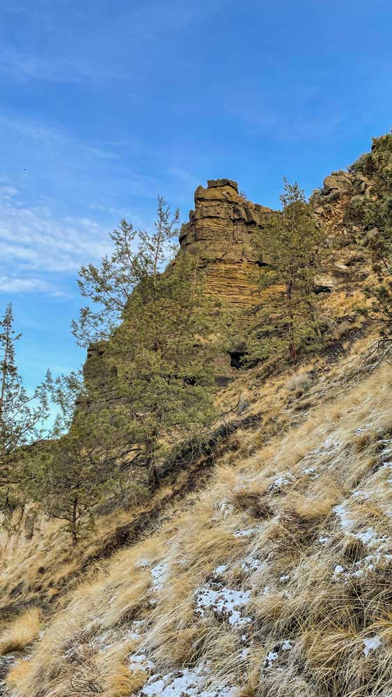
- A basalt rock feature from the Deschutes Formation as seen from the Tam-a-Lau trail.
Visiting Lake Billy Chinook off-season can bring a feeling of peace and quiet that you’ll rarely have in the middle of August. With the marinas closed for the season and the boaters on the water focusing on the ends of their lines rather than the end of a tow rope, the reservoir north of Redmond is calm if a little cold.
But the water and fishing aren’t the only reasons to check out the lake at the Cove Palisades State Park.
For those who want an up-close look at some of the stunning geological features and for a bird’s eye view of the Deschutes and Crooked rivers, take a hike up the 6-mile Tam-a-Lau trail.
Big rocks
One chilly, beautiful recent Saturday, I took my father, Mike, up to the park for a day hike. We equipped ourselves with my 2021 Oregon State Park pass (still required, otherwise day passes are $5) plenty of water, snacks and hiking poles just in case.
You won’t necessarily need the poles unless, like my dad, you have a bad knee or, like me, you have occasional vertigo.
Tam-a-Lau, listed as moderate, is open year-round for hiking only with dogs allowed on a leash . The best time to hike up is in cooler conditions as the trail is largely exposed up at the top and can be extremely hot in the summer months, as well as loud from the activity on the lake below.
Named for the Sahaptin “place of big rocks on the ground” Tam-a-Lau begins in the Deschutes Campground at the state park then hugs the steep hillside above before reaching the relatively flat plateau above.
Right now, the campground is closed for the season, so in order to reach the trailhead, visitors need to park across Jordan Road at the Upper Deschutes Day -use area and walk about a quarter-mile to the trailhead.
The trail first travels over a smaller hill for a little over a quarter-mile before descending into a small valley of large boulders for which the trail gets its name. The break in the trail’s ascension is short, and soon, the bulk of the uphill travel starts. Looking up, you can see the cutout trail zigzag up the 600-foot hillside eventually disappearing behind rock formations near the top.
It’s a mostly uphill climb from there with a few of the steeper sections featuring lumber steps carved into the dirt.
Take your time going up the trail if you need to. It narrows considerably with steep hillsides and drop-offs on either side. So if you need to pass or pause, use the switchbacks — they can be the widest spots in the road. While stopped, check out the view of the lake as you climb and note the changes in the rock as you get closer to the top. These intracanyon basalts from 1.2 million years ago mixed with the thicker bedrock of the Deschutes Formation that formed between 7.5 million and 4 million years ago, which then were cut through by the powerful water flows from the Deschutes, Crooked and Metolius rivers.
Some of the rock formations lay just above the trail so look up every once in a while.
On top of it all
Eventually, the steep zigzagging trail opens up toward the top for the final ascent to the plateau.
During the winter the entire Tam-a-Lau trail is subject to steady freeze-thaw weather patterns (and can sometimes be covered in snow). Because of this, when the sun hits the trail, especially near the top, the ice cover melts and the trail can get quite muddy.
The last section of the uphill travel follows what looks like an old road and is rocky.
Before you know it, you’ll have reached the top and are greeted by a small sign indicating the Tam-A-Lau Loop trail on top of the plateau. This 3.5-mile loop is fairly flat through scrublands of sage and western juniper, hugging the rim of the hillside and offering perfect views of Mt. Jefferson and even Mt. Hood, the Deschutes and Crooked River arms of the lake and a great look at The Island Research Natural Area to the north.
The Island has been closed since 1997 when it was made a protected area. Its remote placement and sheer cliff sides kept it from cattle grazing prior to the lake formation and as such features an untouched landscape with rare plants and animal inhabitants.
Hikers who go clockwise on the loop are greeted to the views immediately. It’s here where you can find a small rock or flat place to sit, enjoy the view and maybe a snack before continuing on your trek around the loop.
Eventually, the trail loops back to the main downhill section and when, if you brought them, the hiking poles can come in handy, especially if you hit a muddy section and your shoe decides it would rather stay behind.


Best of the Best of Bend 2025

-
-
-