Peterson Ridge trail network ideal for mountain bikers of all skill levels
Published 9:15 am Friday, May 7, 2021
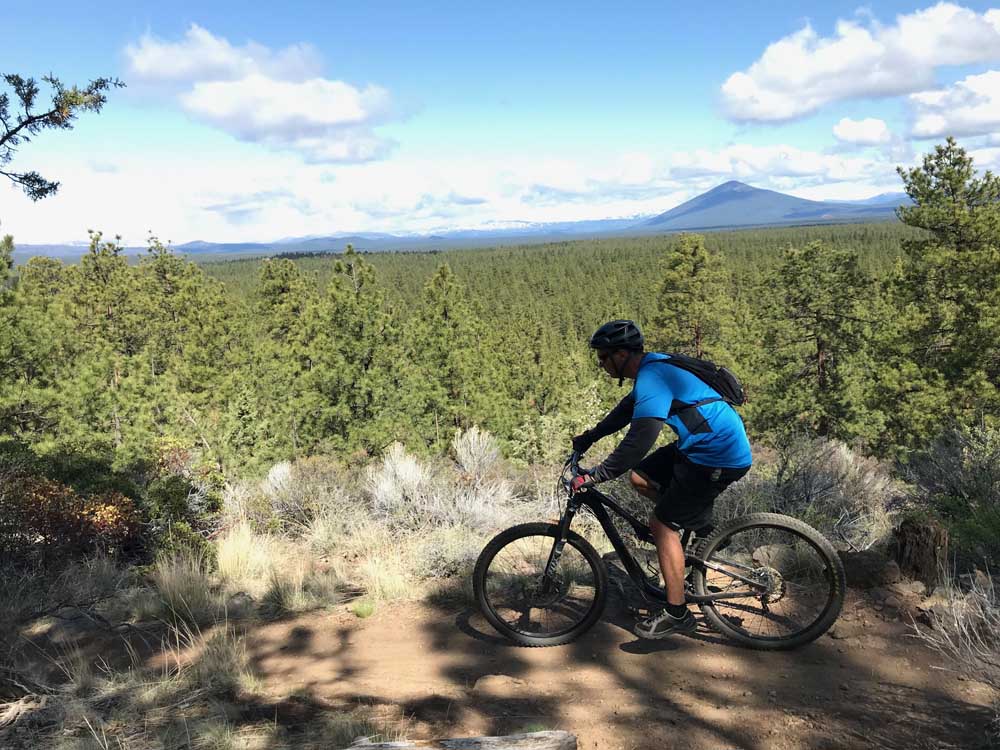
- Bulletin Outdoors Writer Mark Morical rides his mountain bike at Peterson Ridge in May.
SISTERS — A good friend of mine recently moved from ever-crowding Bend to Sisters, craving a more relaxed, small-town lifestyle for his young family.
I did not need another reason to make the half-hour drive to Sisters. I have always enjoyed outdoor adventures in the area, especially along the Peterson Ridge trail system just outside of town.
Trending
Now, I have a willing riding partner in Sisters who can bike to the PRT trailhead.
We met there early Sunday morning, after rainfall from the day before put the trails in perfect shape to quell the dust and make the dirt firm and fast.
The network consists basically of two main trails — Peterson Ridge Trail West and Peterson Ridge Trail East — with about a dozen smaller trails that connect the two sides. The network is well-marked with signs on nearly every trail connector. (The trailhead kiosk is usually stuffed with detailed maps that show every numbered junction in the network.)
The plan was to climb PRT West from the trailhead, then loop back and descend PRT Middle and PRT East. This is my preferred route at Peterson Ridge because PRT West is a bit more technical and cuts alongside the edge of the ridge. Bikers can better enjoy the views as they climb. PRT East features more flow, with sections specifically designed for downhill riding.
We started out climbing gradually through open forest. PRT West took us along smooth singletrack that was flat and easy but became increasingly challenging as we climbed the ridge. The higher we got, the steeper and more technical the trail became, with many sections of lava rock.
Most of the trails in the Peterson Ridge area are not technically demanding or particularly strenuous, but some were built to provide a more technical option for those who seek out that style of riding. PRT West has many such areas.
Trending
Some 10 to 15 years ago, Peterson Ridge consisted of merely one lone 10-mile trail with a small loop on the south end.
But from 2008 to 2010, volunteers with the Sisters Trails Alliance and the Central Oregon Trail Alliance built up the area into a vast network of trails to give mountain bikers, hikers and equestrians more options. The system now includes 30 miles of expertly designed singletrack and seemingly endless loop options.
The network includes several miles of horseback riding trails that are separate from the mountain biking trails. The trails do cross in places, however, so mountain bikers should take care to yield to equestrians.
While the trails at Peterson Ridge are somewhat similar to trails west of Bend — both have gradually sloped singletrack cutting through a ponderosa pine forest — what sets Peterson Ridge apart are numerous Cascade peak views and a litany of loop options in a relatively small area.
More than 15 loop options are possible, varying in distance from 1.4 miles to 20.8 miles. This makes the area welcoming to a variety of skill levels, from beginners looking for a quick, easy ride, to more advanced riders seeking to push themselves.
Spring and fall are the best times of year to ride at Peterson Ridge, as some of the trails become quite dusty in the summertime, much like the Phil’s Trail network west of Bend.
On Sunday, after riding for several miles, we arrived at an overlook where we could take in the dramatic views of Middle Sister and North Sister. A scramble up some rocks provided a view of the vast forest of ponderosa pines and glimpses of other peaks such as Black Butte, Black Crater, Three Fingered Jack and Mount Washington.
We continued climbing along the edge of the ridge until we arrived at yet another viewpoint junction, this one called Peak View. From there, at the far south end of the ridge, we could see Mount Jefferson as well as other peaks. We had climbed nearly 1,000 feet in about 8 miles and were ready for some downhill.
We turned onto the Top Rung connector trail to link up to the PRT Middle and PRT East trails, then began descending through open sagebrush country and back into the ponderosa pine forest.
The east trail features a section of banked corners and up-and-down dips through an old canal, a fun stretch that showcases the ingenuity of the volunteers who built the trail.
After that section the trail steepened, and we picked up lots of speed as we headed back toward the trailhead. We negotiated a few technical rock sections, but for the most part the trail was smooth singletrack back into Sisters.
We only encountered a few other mountain bikers and some hikers on the 16.5-mile ride, as Peterson Ridge is often less crowded than trails closer to Bend.
While the Bend area has more miles of singletrack, Sisters offers an escape from the crowds and a dynamic trail system designed will all ages and skill levels of mountain bikers in mind.
Directions: From Bend, take U.S. Highway 20 to Sisters. Turn left on Elm Street. The trailhead is about a half-mile south off Elm Street, on the left.
Length: Loop options of 2 to 20 miles.
Elevation gain: Up to 1,000 feet.
Trail features: Nearly 30 miles of singletrack. East side offers unique trail with banked corners and small technical areas. West side is a bit more technical, with commanding views of Middle Sister and North Sister along the ridge.
Season: Spring through fall.
Marketplace


Enter the $5,000 Sweepstakes

-
eEdition

-

-