Hiking in the Whychus Canyon Preserve northeast of Sisters
Published 9:07 am Friday, May 14, 2021
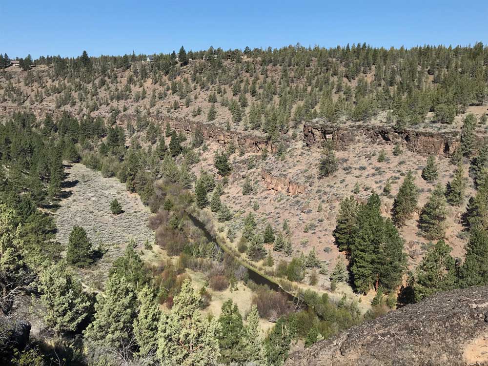
- Whychus Creek flows through the Whychus Canyon Preserve.
Escaping into the outdoors has taken on new meaning, and is a matter of perspective.
For some, a run or hike along the Deschutes River Trail in Bend while encountering 30 others is good enough to break free from the stress of life and soak in the beauty of nature.
Trending
For others, an added dose of solitude and remoteness is required for a true escape.
The Whychus Canyon Preserve northeast of Sisters provides that in spades.
And before my inbox fills up with hate mail for giving away your favorite hiking spot, know this: The Deschutes Land Trust, a local nonprofit, promotes the area because it protected it not only as a haven for fish and wildlife, but also for us to enjoy.
But I understand. As more and more folks discover the benefits of the outdoors and move to Central Oregon, our beloved trails are filling up fast.
The Whychus Canyon Preserve will likely remain a true getaway because of its out-of-the-way location.
Is it the most beautiful hike in Central Oregon, with jaw-dropping mountain views and cascading waterfalls? No. But the area includes nearly 1,000 acres of intriguing canyon and stream terrain where the ponderosa pine forest meets the High Desert.
Trending
In 2010, the Deschutes Land Trust established the preserve to protect 8 miles of Whychus Creek and more than 2,200 acres of adjacent flood plains, wetlands and forests.
The preserve includes several miles of pedestrian-only trails that parallel the creek and the canyon rim, making it an ideal place for hiking, trail-running and bird-watching.
I made the 30-minute drive northwest from Bend on Tuesday and found no other vehicles in the small parking area at the end of a gravel road.
Trails include a rim trail and a creek trail that can be combined for about a 5-mile loop that is fairly moderate with about 500 feet of elevation gain. A trail also cuts through meadows above the rim and follows the Santiam Wagon Road.
I hiked down to the creek first, immersing myself in this remote part of Central Oregon. The trail followed the creek in the bottom of the canyon under the towering rimrock.
The 41-mile Whychus Creek flows out of glaciers on Middle Sister then carves through steep, boulder-lined canyons before making its way through the town of Sisters. Past Sisters, the creek continues northeast through pine forests and High Desert rimrock, eventually converging with the Deschutes River just south of Lake Billy Chinook.
Salmon and steelhead once called Whychus Creek home, and a main objective of the Oregon Department of Fish and Wildlife’s ongoing reintroduction effort is to bring those fish back to Whychus and other streams in the Upper Deschutes watershed.
I linked the creek trail to the rim trail on the north end of the trail system, climbing a steep path out of the canyon. I made my way back toward the trailhead along the rim of the canyon, taking in views of the creek far below and of the Three Sisters on the distant horizon.
A viewpoint along the rim trail offers a chance for some boulder scrambling and a sprawling view of Whychus Creek cutting through the canyon, with the snow-covered Three Sisters and Mount Jefferson rising in the distance above the rimrock.
At the south end of the trail system near the trailhead and information kiosk, hikers can take in more views of the canyon and the Cascade peaks.
According to deschuteslandtrust.org, Whychus Canyon Preserve is home to many native wildflowers. The preserve’s sagebrush plateaus are the first to warm up each spring and include some of the earliest blooms in Central Oregon.
Unfortunately, it was still a little too early in the season for me to take in the wildflowers in their full splendor. But I did notice some small yellow and purple plants beginning to appear alongside the trail. Over the next few weeks the area should offer hikers a chance to enjoy a walk among the more fully bloomed wildflowers.
The 5-mile hike/trail run required about two hours and was only moderately difficult along the short, steep sections that connect the creek trail and rim trail. I saw only one other person along the trail during my outing — a trail-runner on the rim trail.
Back at the trailhead, two other cars had arrived with a few hikers looking to escape into the outdoors, and into Whychus Canyon.
Getting there: From Bend, drive northwest on U.S. Highway 20 for about 13 miles. Turn north on Fryrear Road and continue 5.5 miles to the intersection with state Highway 126. Turn left on Highway 126, travel 1 mile, then turn right on Goodrich Road. Follow Goodrich Road for about 1.5 miles until the paved road turns sharply right. Instead of following the curve, go straight onto the gravel road, following it for about 1.3 miles to a split in the road. Keep going straight north for another 0.4 miles to the trailhead parking area.
Difficulty: Easy if you stay on the canyon rim, intermediate to difficult if you follow the 5-mile loop down into the canyon. Trails are open to hikers only, and dogs must be on leash at all times.
Contact: deschuteslandtrust.org or 541-330-0017
Marketplace


Enter the $5,000 Sweepstakes

-
eEdition

-

-