Conditions report for High Desert trails, camping, fishing
Published 12:00 am Friday, June 4, 2021
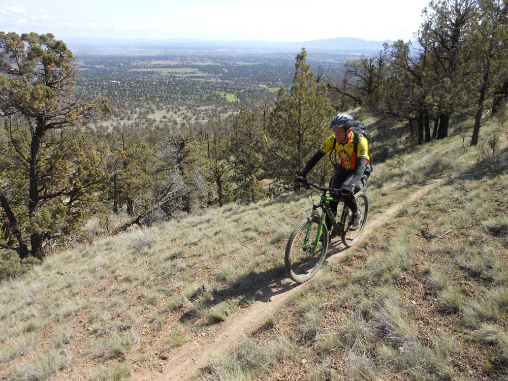
- Mark Morical/Bulletin file photoA mountain biker rides along singletrack on Cline Buttes.
Looks like our June heatwave has subsided, and temps will be returning to a normal level this weekend. So get out and explore all the High Desert has to offer before the mercury rises again.
Bring plenty of water and sunscreen and keep an eye out for wildflowers and critters wherever you venture this week.
For a full list of conditions updated regularly, please visit centraloregonexplore.com.
Hiking and Day Use Sites
NOTE: Many high elevation trails are open but are on seasonally closed or unmaintained roads and can only be able to be accessed by hiking in while the trails themselves may still be under deep snow. See Forest websites for more details and restrictions.
Deschutes National Forest
Bessie Butte Trail: Open
Boyd Cave Day Use Area: Open
Horse Butte Trailhead: Open; snow and deadfall likely above Swamp Wells Horse Camp
Pine Mountain: Open
Ochoco National Forest
Alder Springs Trailhead: Open
Cyrus Trailhead: Open
Gray Butte Trailhead: Open
Henderson Flat OHV Trail System: Open
Henderson Flat Staging Area: Open
Rimrock Springs Trailhead: Open
Scales Corral Trailhead: Open
Skull Hollow Trailhead: Open
Tam-A-Lau Trailhead: Open
Trail Crossing Corrals Trailhead: Open
Bureau of Land Management
Badlands Rock Trail: Open
Black Hills ACEC: Open; climbing and geocaching are prohibited
Chimney Rock Trail: Open
Christmas Valley Sand Dunes: Open
Cline Buttes Recreation Area: Portions of Deep Canyon, Fryrear, Maston and Jaguar Road are closed through Aug. 31
Crack-in-the-Ground: Open
Derrick Cave: Open
Flatiron Rock Trail: Open
Fossil Lake ACEC: Open; motor vehicles and fossil collecting prohibited
Green Mountain: Open
Huntington Wagon Road: Open
Lost Forest: Open, vehicles restricted to designated roads only
Lower Crooked River: Open
North Fork: Open
Oregon Badlands Wilderness Tumulus Trail: Open
Redmond Caves Recreation Site: Open
Scout Camp Trail: Open
Steelhead Falls Trail: Open
Trout Creek Trail: South side of trail, including Trout Creek climbing walls is closed through Aug. 31
Oregon State Parks
Cline Falls State Scenic Viewpoint: Open
Cove Palisades State Park: Open; all campgrounds, cabins and moorage slips are open
Fort Rock State Natural Area: Open; day-use hours 8 a.m,-8 p.m.; rock scrambling closed in southeast area to protect nesting falcons; cave tours canceled for 2021
Jasper Point: Open
Peter Skene Ogden State Scenic Viewpoint: Open
Prineville Reservoir State Park: Open; no boat moorage; Powderhouse cove boat ramp is closed; Prineville Resort is closed and no fuel is available for purchase
Smith Rock State Park: Open — some services reduced and facility closures may be in pace; Bivouac camping open with limited availability, tent camping only, no reservations, showers for guests only; climbing closures to protect nesting raptors in place until August; park-wide drone ban is in effect.
Camping
Deschutes National Forest
Pine Mountain Campground: Open
Ochoco National Forest
Cyrus Horse Camp: Open
Haystack Reservoir Campground and Day Use Area: Open
Haystack Reservoir Group Site: Open
Haystack West Shore Campground and Day Use Area: Open
Skull Hollow Campground: Open
BLM — Prineville District
Barr Road North Staging Area: Open
Big Bend Campground: Open
Buckhorn Staging Area: Open
Castle Rock Campground: Open
Chimney Rock Campground: Open
Cobble Rock Campground: Open
Lone Pine Campground: Open
Macks Canyon Recreation Site: Open
Palisades Campground: Open
Post Pile Campground: Open
Steelhead Falls: Open; no potable water
Stillwater Campground: Open
Cycling
East of Bend trails
Dry River Canyon: Closed through Aug. 31
Crooked Arm, Holy Loop, Sand Canyon: Sandy and loose
Swamp Wells: Riding well, deadfall reported
All other trails riding well
Prineville and Ochoco trails
Independent Mine, Round Mountain: Winter mix
Lookout Mountain: Winter mix; deadfall reported
Cougar Creek: Riding well, deadfall reported
All other trails riding well
Maston complex
All trails riding well
Redmond trails
The Saddle: Closed for nesting eagles, likely to reopen late fall of 2021
All trails riding well
Madras East Trails
All trails riding well
Fishing
Updated at 8 a.m. June 3
Lower Deschutes (Pelton Dam to Columbia River): 4,610 cfs; redband trout, steelhead, whitefish
Middle Deschutes (Benham Falls to Lake Billy Chinook): 4,030 cfs; brown trout, rainbow trout; anglers reporting good fishing and hatches are coming out during the warmest part of the day; artificial flies and lures only, no limit on brown trout
Crooked River (below Opal Springs): 1,186 cfs; rainbow trout and mountain whitefish; water level is higher but will be lower than average this summer; any trout over 20 inches are considered steelhead and must be released, bull trout must be released unharmed and reported to the USFW at crookedbulltrout@fws.gov
Metolius River: 1,700 cfs; bull trout, rainbow trout; good fishing and active hatches during warmest part of the day; fly fishing only upstream of Bridge 99, artificial lures and flies permitted below; catch and release only; public access to Wizard Falls Hatchery remains closed
Prineville Reservoir: 53% full; rainbow trout, small and largemouth bass, catfish, crappie, crayfish; bass and trout fishing has been good
Ochoco Reservoir: 22% full; rainbow trout, black crappie, smallmouth bass; water level is still extremely low and bank access is limited to walk-in only
Haystack Reservoir: 70% full; rainbow and brown trout, kokanee, largemouth bass, black crappie, bluegill and bullhead catfish; bass fishing should be good, trout will be harder to catch during the middle of the day especially from shore
Lake Billy Chinook: Bull, brown and rainbow trout, kokanee, smallmouth bass; bass fishing picking up with kokanee and bull trout fishing being fair
Fire danger is currently listed as Moderate in the Deschutes and Ochoco National Forests. Fire danger is listed as Low in the Willamette National Forest.
Industrial Fire Precaution Level is currently at Level 1 for the Deschutes and Ochoco national forests and the Prineville District — Bureau of Land Management.
To protect nesting raptors, the following climbing routes are closed: Cajun Cliff, Victoria Tower, Little Three Fingered Jack, Puddy’s Tower, The Monument, Anglin’s Buttress, French Tent Rock, First Kiss Area north of Monkey Face and Smith Rock Group NE Face (both towers, above 100 feet).
The Canyon Trail near the bald eagle nest is restricted to groups of four or less and noise must be kept to a minimum.
See smithrock.com/seasonal-closures for more information.
The following Bureau of Land Management trails are now closed through Aug. 31 to protect nesting raptors:
- Millican Plateau OHV Trail System (Route 95 only)
- South side of Trout Creek Trail including climbing walls
- Cline Buttes Recreation Area (portions of Deep Canyon, Fryrear, Maston, Jaguar Road)
- Horny Hollow Trail
- Dry River Canyon
For more information visit blm.gov

Best of the Best of Bend 2025

-
-
-