La Niña arrives, raising hopes for snowpack build-up
Published 8:15 am Friday, December 10, 2021
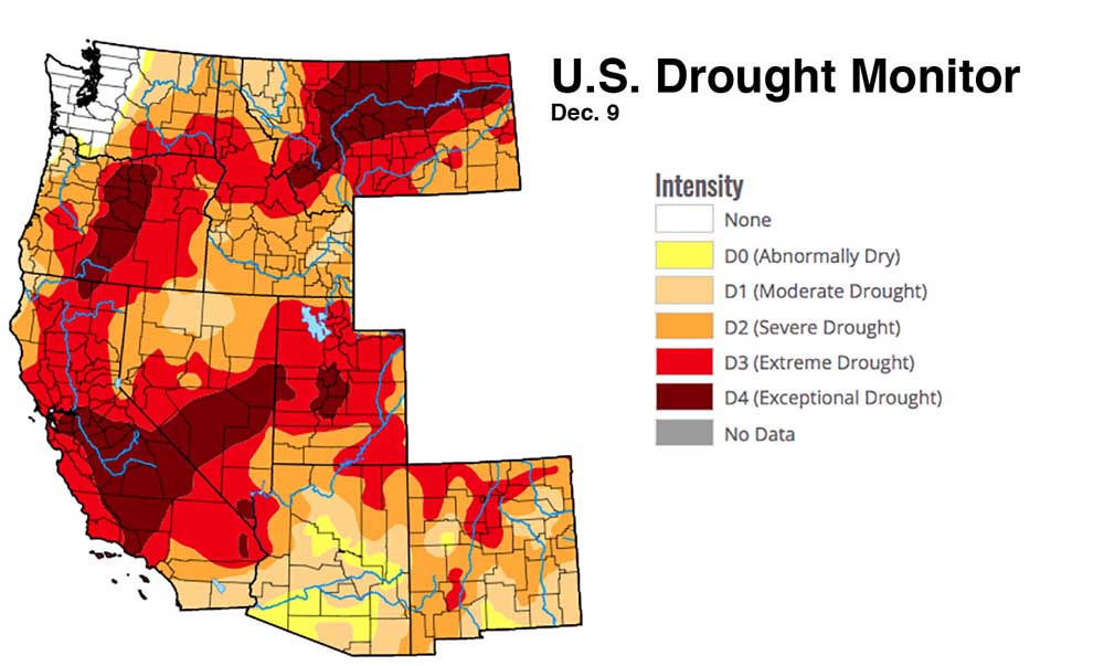
- This U.S. Drought Monitor map released Thursday shows the central portion of the state including much of Crook, Deschutes and Jefferson counties in exceptional drought.
La Niña has apparently arrived in the Northwest, signaling a shift to cooler weather and more promising snowpacks, Washington State Climatologist Nick Bond said Thursday.
November was wet but warm, causing flooding in northwest Washington, but little snow in the Cascade Range. Bond said Thursday he anticipates weather patterns will change, dropping snow in the mountains without raising the risk of floods.
Trending
“Things have kind of turned around,” he said. “December looks like a different kind of month than November.
“No guarantee it will stay that way for the entire winter, but at least for the rest of this month, it looks like there will be good mountain snows,” Bond said.
The National Oceanic and Atmospheric Administration said Thursday there’s a 95% chance that La Niña will prevail until the spring.
A La Niña generally leads to cool and wet winters in the northern U.S., but warm and dry winters in the southern U.S.
The La Niña could relieve drought in some parts of the West, but deepen it in other parts.
This will be the second La Niña winter in a row.
Trending
Bond said the storms that hammered northwest Washington in late November originated farther south than storms expected to be ushered in by La Niña.
The National Weather Service predicted Thursday heavy snows in the Cascades over the next several days. As of early Friday afternoon, Mt. Bachelor reported 5 inches of snow in 24 hours and about 28 inches total, according to its website. The ski area’s weather forecast predicted snow or a chance of snow through Tuesday.
Northwest snowpacks were below normal. In some basins, they were far below average.
The November storms in northwest Washington were “kind of a fluke” and “not a new normal,” but higher global temperatures may not cause such storms to have more moisture in the future, Bond said.
“That is something that is quite possible,” he said. “But it’s not like every year will have floods like this one.”
The U.S. Drought Monitor reported Thursday that Western Washington and Clatsop and Tillamook counties in northwest Oregon were the only regions in nine western states that aren’t at least abnormally dry.
Some 94% of the West is in some stage of drought, ranging from moderate to exceptional.
NOAA’s Climate Prediction Center forecasts cool and wet weather in the Northwest for December, January and February.
A swathe of Central Oregon, making up 21% of the state, remains in exceptional drought.
All of Idaho is in drought, including 25% in extreme drought. California also is entirely in drought, including 28% in exceptional drought.

Best of the Best of Bend 2025

-
eEdition

-

-