Dry January aggravates drought conditions across Northeast Oregon
Published 7:00 am Saturday, February 19, 2022
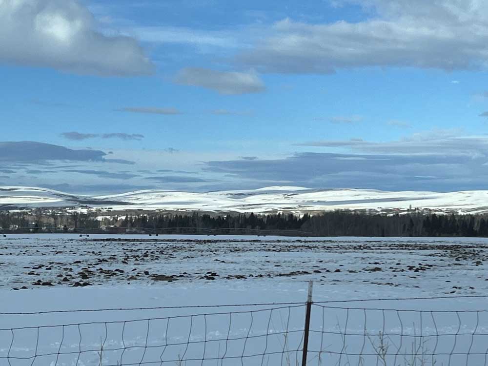
- Snow remains on the ground in the Wallowa Valley in February 2022. Cold temperatures have held snow on mountains and valley bottoms throughout Northeastern Oregon several weeks after heavy snowstorms blasted the region in Oregon in late December and the first week of January.
PENDLETON — December and January storms set up the winter of 2022 to be cold and wet, but several weeks without significant snow or rain are creating concerns of another drought year.
Northeast Oregon is faring better than Central and Southern Oregon, with cold temperatures preventing the early January snowfall from melting. Snow in the last few days has helped inch up snowpack and snow water equivalent levels for the Blue and Wallowa mountains.
According to the USDA Natural Resources Conservation Service website, monthly streamflow and reservoir conditions for January in the Umatilla-Walla Walla-Willow Basin were above average. Two bodies of water in the southern region of the basin near Heppner are considerably higher than the rest of the basin: Willow Creek is at 187% and Rhea Creek is at 142% of the 30-year median.
Farther south, the North Fork John Day River at Monument is recording 83% of its 30-year median. The basin has one stronghold for water: Camas Creek near Ukiah at 346% of the median.
The Grande Ronde-Burnt-Powder-Imnaha Basin is averaging between 83% and 95% of the 30-year median with one anomaly: Bear Creek, outside of Wallowa, is at 216%.
Snowpack has been holding up, despite the lack of precipitation in the last five weeks.
In the Blue Mountains between La Grande and Pendleton, Emigrant Springs has 45 inches of snowpack and is 148% above average with 10% snow water equivalent. High Ridge Snotel east of Pendleton has 52 inches of snowpack, 5% below its average, but with 33% snow water equivalent. Milkshakes Snotel on the Washington state line has 71 inches of snowpack, which is 87% of normal with 35% snow water equivalent.
In the Wallowas, Mount Howard has 27 inches of snowpack, 25% below average with 32% snow water equivalent. On the south side of the range, Moss Springs Snotel is recording 49 inches of snowpack, which is 15% below average with a snow water equivalent of 32%.
In Baker County, Schneider Meadows Snotel is recording 22% below normal precipitation and has 55 inches of snowpack with a 33% snow water equivalent.
In Central Oregon, after a burst of snowfall slammed the area in late December and early January, snowpack levels surged to 130% of average, but dry conditions since those storms have erased much of those gains. A Feb. 12 report in The Bulletin put the snowpack in the Upper Deschutes and Crooked River basin at 92% of normal, with precipitation for the water year at 89% of normal, according to the Natural Resources Conservation Service.
While Northeast Oregon’s snowpack and water levels look good now, the area is facing down the barrel of another drought year, according to the National Oceanic and Atmospheric Administration. According to www.drought.gov, Wallowa County was down 0.69 inches of precipitation in January. The entire county is considered to be in severe drought status, and 44.36% of the county is experiencing extreme drought conditions.
Union County is down 0.27 inches of its average precipitation. The entire county is considered to be under severe drought conditions while 4.3% is experiencing extreme drought. And Umatilla County is down 0.2 inches of precipitation from a normal January. This puts all of the county under severe drought conditions, with 33.77% considered to be under extreme drought conditions.
The extended forecast for Northeast Oregon calls for 33% to 40% below normal precipitation with a 40% to 50% chance of above normal temperatures.
Pendleton and the surrounding area is expected to see rain on Sunday, Feb. 20, and possibly snow on Feb. 21. Overnight lows will dip into the teens this coming week with daytime highs in the upper 20s to mid-30s.
The La Grande area is projected to receive rain that will turn to snow as temperatures drop on Feb. 20 and Feb. 21. Starting Feb. 21, overnight lows will be in the 20s and teens with daytime highs in the upper 20s and 30s.
Wallowa County will likely see snow beginning the night of Feb. 19, continuing through Feb. 21. Overnight lows will be in the teens and single digits, with below-zero temperatures forecasted for overnight on Feb. 22. Daytime highs for the Wallowa Valley will be in the teens and 20s.
Snow is expected to come to Baker County the night of Feb. 19 and continue through Feb. 20 and Feb. 21. Overnight lows for the week will be in the teens and 20s while daytime highs will likely be in the upper 20s to upper 30s.


Best of the Best of Bend 2025

-
-
-