Swamp Wells and Coyote Loop offer varied bike terrain near Bend
Published 4:00 am Friday, May 6, 2022
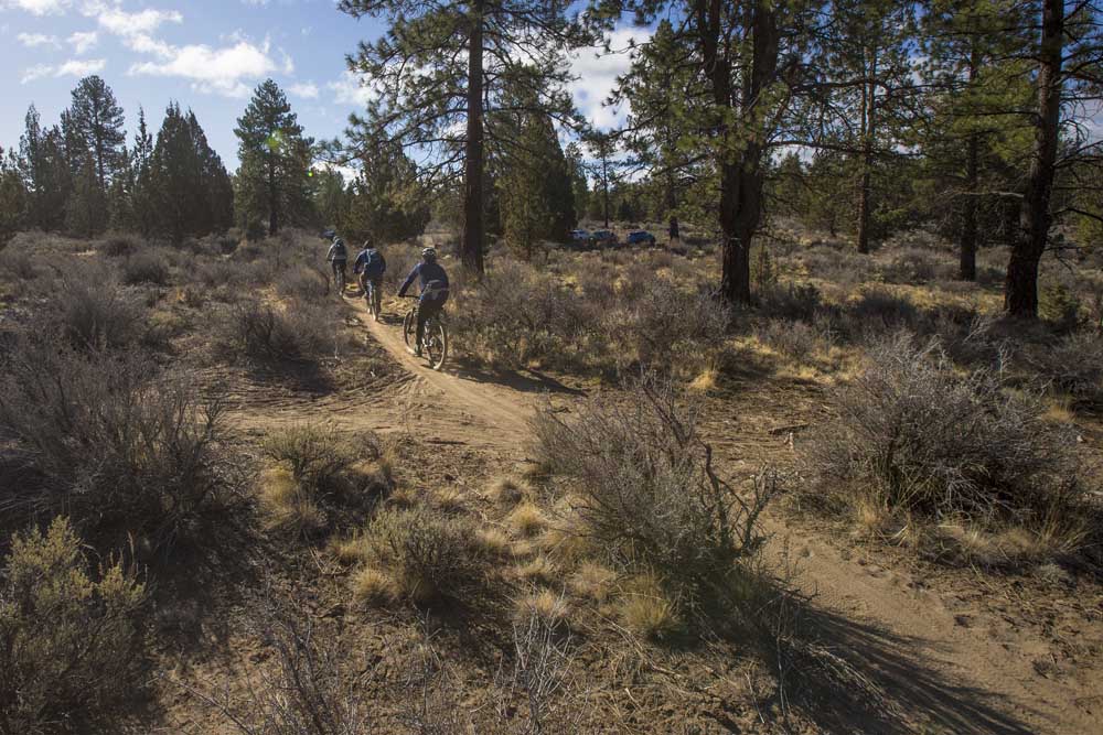
- A trio of riders make their way down a trail while mountain biking near Horse Butte.
Bend is known as a place of varied ecosystems. The type of terrain and natural surroundings you find depends on which direction you go.
Head west for deep ponderosa pine forests and snow-covered Cascade peaks. Go east for the sagebrush- and juniper-laden High Desert.
Trending
The Swamp Wells and Coyote Loop trails southeast of Bend offer both types of terrain for mountain bikers looking for a variety of Central Oregon singletrack flavor.
The trails combine for a 22-mile loop with 1,500 feet of elevation gain.
On a recent Sunday, I drove southeast down China Hat Road about 4½ miles and parked at the Bessie Butte Trailhead, planning to ride the Swamp Wells Trail south and then connect to the Coyote Loop Trail for the ride back north.
Swamp Wells runs all the way to Newberry Crater more than 20 miles to the south, but most mountain bikers only ride the bottom sections to make loops in the 10- to 30-mile range.
The singletrack was in ideal shape, featuring a few technical rock sections but mostly smooth dirt. From Bessie, the Swamp Wells Trail was a gradual climb toward Kelsey Butte, about 5 miles to the south.
I continued through the forest, and as I got closer to Kelsey Butte the trail became steeper and steeper. Eventually it turned into a grueling climb, but one well worth the payoff.
Trending
The trail, with a couple of switchbacks, led to a viewpoint about halfway up 5,372-foot Kelsey Butte. From that perch, I could see numerous glowing white peaks in the Cascade Range: Mount Bachelor, Broken Top, the Three Sisters, Mount Jefferson and Mount Hood.
Many buttes dot the area off China Hat Road, including Coyote Butte, Horse Butte and Cabin Butte among a few others.
After wrapping around the base of Kelsey Butte, the Swamp Wells Trail continues south past many other buttes all the way to the Newberry Crater Rim Trail.
After 10 miles and much climbing, I welcomed the left turn onto the Coyote Loop Trail, knowing that the downhill would soon come.
The trail back north was fast and flowing as I weaved through the forest along the mostly pristine singletrack. After a few miles, I was out of the trees and cruising through the desert, the warm sun inviting after such a chilly April.
I continued the thrilling descent, eventually coming to a spot with a beautiful eastward view of Pine Mountain, Horse Ridge, Powell Butte and Smith Rock.
Eventually, I arrived back at the paved China Hat Road, along which I could ride back to Bessie Butte. But I decided to ride a few more miles of singletrack in the Horse Butte area.
The relatively flat and nontechnical trails near Horse Butte traverse the burn where the 1996 Skeleton Fire scorched 17,000 acres, opening up sprawling views in every direction and leaving behind sagebrush and bare juniper trees.
I continued along the Coyote Loop Trail, which would lead me toward the Horse Butte Trailhead. I cruised through the sagebrush and past old juniper trees as the snow-covered mountains dominated the horizon.
It is extremely important that all user groups cooperate in areas like Horse Butte, where frequent users include hikers, trail runners, mountain bikers and equestrians. Mountain bikers are required to yield to pedestrians and horseback riders.
After arriving at a junction near the Horse Butte Trailhead, I made a left back onto Swamp Wells, and rode a few miles back through the forest to Bessie Butte. The entire loop required about three hours.
The Swamp Wells and Coyote Loop trails can become extremely sandy in the summer, but they should remain in good riding condition well into May, offering mountain bikers a chance to experience a variety of Central Oregon terrain.
Marketplace

Best of the Best of Bend 2025

-
eEdition

-

-