Central Oregon outdoors and trail conditions
Published 12:00 am Friday, July 22, 2022
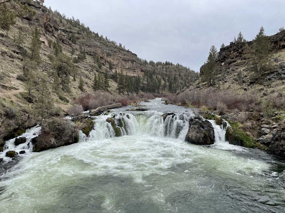
- Steelhead Falls on the Middle Deschutes near Crooked River Ranch.
It may seem an odd time to head to the arid and sparsely shady High Desert terrain around Central Oregon, but with a little planning and a lot of water, a good time hiking, biking or fishing can be had.
Aim for the cooler early hours, make sure you’re prepared for very hot temperatures and bring more water than you may think you need.
For a full list of conditions updated regularly, please visit centraloregonexplore.com
Hiking and Day Use Sites
NOTE: Trails above 7,000 ft. are under deep snow. The snow line is around 5,700 ft. See forest websites for more details and restrictions.
Cascade Wilderness permits are required for 19 trailheads for day use and all trailheads for overnight use in the Mt. Jefferson, Mt. Washington and Three Sisters Wildernesses from June 15 through Oct. 15.
Ochoco National Forest
- Alder Springs Trailhead: Open
- Antelope Flat Reservoir: Open
- Baneberry Trailhead: Open
- Barnhouse Trailhead: Open
- Black Canyon East (Formerly South Fork) Trailhead: Open
- Black Canyon West (Formerly Dusty Camp) Trailhead: Open
- Boeing Field Trailhead: Open
- Coffeepot Trailhead: Open
- Cottonwood Trailhead: Open
- Cougar East Trailhead: Open
- Cougar West Trailhead: Open
- Cyrus Trailhead: Open
- Fry Trailhead: Open,
- Giddy-Up Go Trailhead: Open
- Gray Butte Trailhead: Open
- Green Mountain North Trailhead: Open
- Green Mountain South Trailhead: Open
- Hammer Creek Trailhead: Open
- Henderson Flat OHV Trail System: Open
- Henderson Flat Staging Area: Open
- Keeton Trailhead: Open
- Kelsey Trailhead: Open
- Line Butte East (Formerly Fawn Creek) Trailhead: Open
- Line Butte West Trailhead: Open
- Lookout Mountain Lower Trailhead: Open
- Lookout Mountain Upper Trailhead: Open
- Mascall Corral (Formerly Apple West) Trailhead: Open
- Mother Lode Mine Trailhead: Open
- Payten Trailhead: Open
- Potlid North Trailhead: Open
- Potlid South Trailhead: Open
- Rim (Formerly Apple Middle) Trailhead: Open
- Rimrock Springs Trailhead: Open
- Rock Creek Trailhead: Open
- Round Mountain North Trailhead: Open
- Round Mountain South Trailhead: Open
- Scales Corral Trailhead: Open
- Skull Hollow Trailhead: Open
- South Prong Trailhead: Open
- Steins Pillar Trailhead: Open
- Tam-A-Lau Trailhead: Open
- Trail Crossing Corrals Trailhead: Open
- Twin Pillars North Trailhead: Open
- Twin Pillars South Trailhead: Open
- Walton Lake Trailhead: Closed
- Wildcat North Trailhead: Open
- Wildcat South Trailhead: Open
Bureau of Land Management
- Badlands Rock Trail: Open
- Black Hills ACEC: Open; climbing and geocaching are prohibited
- Chimney Rock Trail: Open
- Christmas Valley Sand Dunes: Open
- Cline Buttes Recreation Area: Open
- Crack-in-the-Ground: Open
- Derrick Cave: Open
- Flatiron Rock Trail: Open
- Fossil Lake ACEC: Open; motor vehicles and fossil collecting prohibited
- Green Mountain: Open
- Huntington Wagon Road: Open
- Lost Forest: Open, vehicles restricted to designated roads only
- Lower Crooked River: Open
- North Fork: Open
- Oregon Badlands Wilderness Tumulus Trail: Open
- Redmond Caves Recreation Site: Open
- Scout Camp Trail: Open
- Steelhead Falls Trail: Open
- Tumalo Reservoir: Open
- Trout Creek Trail: Open
Oregon State Parks
- Cline Falls State Scenic Viewpoint: Open
- Cove Palisades State Park: Open; ABC (Deschutes) Campground, South and Middle Loops of E (Crooked River) are open, Lower Deschutes Day Use open, marina open
- Jasper Point: Open; boats with motors are not advised due to low water; Prineville Reservoir, Powderhouse Cove and Jasper Point boat ramps closed
- Peter Skene Ogden State Scenic Viewpoint: Open
- Prineville Reservoir State Park: Open; boats with motors are not advised due to low water; Prineville Reservoir, Powderhouse Cove and Jasper Point boat ramps closed
- Smith Rock State Park: Open, look for the posted climbing closure signs in the Monument Area due to raptor nesting, park-wide ban on drones for raptor nesting season
Camping
Ochoco National Forest
- Allen Creek Horse Camp: Open; no campfires
- Antelope Flat Reservoir Campground and Day Use: Open
- Barnhouse Campground: Open; no campfires
- Big Spring Campground: Open; no campfires
- Biggs Springs Campground: Open; no campfires
- Bingham Springs Campground: Open; no campfires
- Cold Springs Guard Station: Open; no campfires
- Cottonwood Campground: Open; no campfires
- Cottonwood Pit Campground: Open; no campfires
- Cyrus Horse Camp: Open; no campfires; no campfire Creek Campground: Open
- Dry Creek Horse Camp: Open; no campfires
- Elkhorn Campground: Campground: Open; no campfires
- Frazier Campground: Open; no campfires
- Haystack Reservoir Campground and Day Use Area: Open
- Haystack Reservoir Group Site: Open
- Haystack West Shore Campground and Day Use Area: Open
- Mud Springs Horse Camp: Open; no campfires
- Ochoco Divide Campground: Open
- Ochoco Divide Group Site: Open
- Ochoco Forest Campground: Open
- Ochoco Forest Camp Group Pavillion: Open
- Ochoco Ranger Rental House: Open; no campfires
- Salters Cabin Horse Camp: Open; no campfires
- Scotts Campground: Open
- Skull Hollow Campground: Open
- Sugar Creek Campground and Day Use Area: Open
- Walton Lake Campground: Open
- Walton Lake Group Campsites: Open
- Whistler Campground: Open; no campfires
- White Rock Campground: Open; no campfires
- Wildcat Campground and Day Use Area: Open
- Wildwood Campground: Open; no campfires
- Wiley Flat Campground: Open; no campfires
- Wolf Creek Campground: Open
- Wolf Creek Industrail Campground: Open
BLM — Prineville District
- Barr Road North Staging Area: Open
- Big Bend Campground: Open; no campfires
- Buckhorn Staging Area: Open
- Castle Rock Campground: Open
- Chimney Rock Campground: Open
- Cobble Rock Campground: Open
- Lone Pine Campground: Open
- Macks Canyon Recreation Site: Open; no campfires
- Palisades Campground: Open
- Post Pile Campground: Open
- Steelhead Falls: Open; no potable water; no campfires
- Stillwater Campground: Open
Cycling
Prineville and Ochoco trails
- Scotty Creek: Variable
- All other trails riding well
Maston complex
- All trails riding well
Redmond trails
- All trails riding well
Madras East Trails
- E-Bikes allowed on all trails
- All trails riding well
Fishing
Updated at 10 a.m. July 21
- Lower Deschutes (Pelton Dam to Columbia River): 4,560 cfs; redband trout, steelhead, whitefish; emergency closure from mouth to Pelton Dam in effect for all steelhead angling till Aug. 15; Trout fishing and retention remains open, and fishing reports suggest pretty good fishing out of Maupin; no spring Chinook season in 2022 due to another year of predicted poor returns of both wild and hatchery fish
- Middle Deschutes (Benham Falls to Lake Billy Chinook): 3,730 cfs; brown trout, rainbow trout; no recent report; artificial flies and lures only, no limit on brown trout
- Crooked River (below Opal Springs): 1,230; rainbow trout and mountain whitefish; any trout over 20 inches are considered steelhead and must be released, bull trout must be released unharmed and reported to the USFW at crookedbulltrout@fws.gov, the water is currently low and dirty with plenty of aquatic vegetation in the channel
- Metolius River: 1,410 cfs; bull trout, rainbow trout; good fishing reported; fly fishing only upstream of Bridge 99, artificial lures and flies permitted below; catch and release only; public access to Wizard Falls Hatchery remains closed
- Prineville Reservoir: 23% full; rainbow trout, small and largemouth bass, catfish, crappie, crayfish; trout fishing has been good near the dam, all boat ramps are closed due to low water
- Ochoco Reservoir: 22% full; rainbow trout, black crappie, smallmouth bass; water level is still extremely low and bank access is limited to walk-in only
- Haystack Reservoir: 55% full; rainbow and brown trout, kokanee, largemouth bass, black crappie, bluegill and bullhead catfish
- Lake Billy Chinook: Bull, brown and rainbow trout, kokanee, smallmouth bass; anglers in the Deschutes arm are seeing bull, brown and rainbow trout, while a few bull trout are being caught in the Metolius arm; for the remainder of the reservoir, harvest is limited to one bull trout over 24 inches under the daily trout limit; anglers can now keep five kokanee in addition to daily trout limit; no bag or size limits on brown trout and bass
- Walton Lake: Rainbow trout; no recent update
Fire danger is currently listed as High in the Deschutes, Ochoco and Willamette National Forests and Crooked River Grasslands.
Industrial Fire Precaution Level has been lowered to Level 1 as of April 1
As of July 22, 2020 Deschutes River access is closed due to safety concerns and to prevent further erosion to the riverbank. The access point will be closed until further notice. For more information visit bendparksandrec.org
• Peregrine and Prairie Falcon climbing closures are now in place for the First Kiss area (north of Monkey Face)and the Smith Rock Towers areas.
• A parkwide ban on drones is in effect for remainder of nesting season.


Best of the Best of Bend 2025

-
eEdition

-

-
Go! eEdition