Central Oregon outdoors, ski and trail conditions
Published 3:00 pm Thursday, March 9, 2023
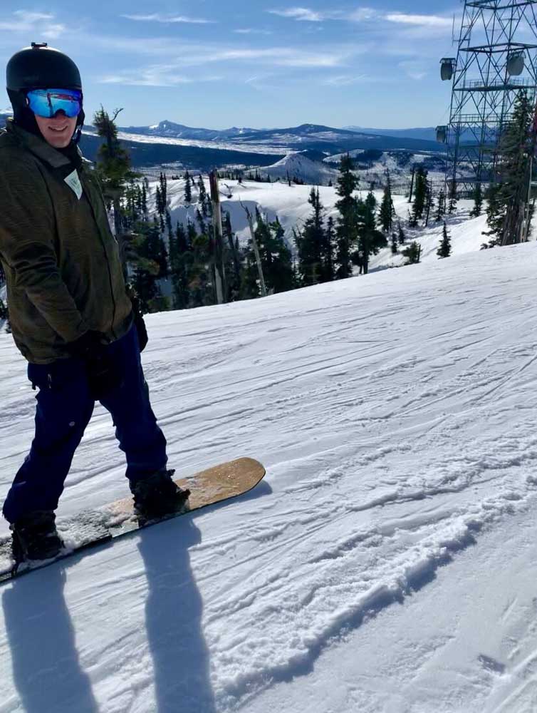
- Dylan Lipke snowboarding at Hoodoo Ski Area.
After recent snowfall, many area trails may have a good covering of snow to crunch through this weekend. The weather looks slightly milder, with some rain and sun to be expected in the Redmond and Prineville areas.
Remember, the weather can change quickly in Central Oregon, so always be prepared and have a backup plan.
For a full list of conditions updated regularly, please visit centraloregonexplore.com
Hiking and Day Use Sites
NOTE: There is substantial snow in area sno-parks, and all summer trails have snow on them. While the Forest Service doesn’t close these trails during the winter, summer trails are only accessible by snowshoeing, cross country skiing or snowmobiling due to accumulated snowpack. And remember, many of these trails are along seasonally closed highways that are unplowed and cannot be accessed by car or foot. Know the current conditions and you and your cars abilities before heading out on any adventure.
See forest websites for more details and restrictions.
Ochoco National Forest
- Alder Springs Trailhead: Open
- Antelope Flat Reservoir: Open
- Baneberry Trailhead: Open
- Barnhouse Trailhead: Open
- Black Canyon East (Formerly South Fork) Trailhead: Open
- Black Canyon West (Formerly Dusty Camp) Trailhead: Open
- Boeing Field Trailhead: Open
- Coffeepot Trailhead: Open
- Cottonwood Trailhead: Open
- Cougar East Trailhead: Open
- Cougar West Trailhead: Open
- Cyrus Trailhead: Open
- Fry Trailhead: Open,
- Giddy-Up Go Trailhead: Open
- Gray Butte Trailhead: Open
- Green Mountain North Trailhead: Open
- Green Mountain South Trailhead: Open
- Hammer Creek Trailhead: Open
- Henderson Flat OHV Trail System: Open
- Henderson Flat Staging Area: Open
- Keeton Trailhead: Open
- Kelsey Trailhead: Open
- Line Butte East (Formerly Fawn Creek) Trailhead: Open
- Line Butte West Trailhead: Open
- Lookout Mountain Lower Trailhead: Open
- Lookout Mountain Upper Trailhead: Open
- Mascall Corral (Formerly Apple West) Trailhead: Open
- Mother Lode Mine Trailhead: Open
- Payten Trailhead: Open
- Potlid North Trailhead: Open
- Potlid South Trailhead: Open
- Rim (Formerly Apple Middle) Trailhead: Open
- Rimrock Springs Trailhead: Open
- Rock Creek Trailhead: Open
- Round Mountain North Trailhead: Open
- Round Mountain South Trailhead: Open
- Scales Corral Trailhead: Open
- Scotty Creek Trailhead: Open
- Skull Hollow Trailhead: Open
- South Prong Trailhead: Open
- Steins Pillar Trailhead: Open
- Tam-A-Lau Trailhead: Open
- Trail Crossing Corrals Trailhead: Open
- Twin Pillars North Trailhead: Open
- Twin Pillars South Trailhead: Open
- Walton Lake Trailhead: Closed
- Wildcat North Trailhead: Open
- Wildcat South Trailhead: Open
Bureau of Land Management
- Chimney Rock Trail: Open
- Cline Buttes Recreation Area: Open
- Horny Hollow Trail: Open
- Huntington Wagon Road: Open
- Lower Crooked River: Open
- North Fork: Open
- Redmond Caves Recreation Site: Open
- Scout Camp Trail: Open
- Steelhead Falls Trail: Open
- Trout Creek Trail: Open
Oregon State Parks
- Cline Falls State Scenic Viewpoint: Open
- Cove Palisades State Park: Open; ABC (Deschutes) Campground, South and Middle Loops of E (Crooked River) are open, Lower Deschutes Day Use open, marina open
- Jasper Point: Open; boats with motors are not advised due to low water
- La Pine State Park: Open
- Peter Skene Ogden State Scenic Viewpoint: Open
- Prineville Reservoir State Park: Open; boats with motors are not advised due to low water
- Smith Rock State Park: Open look for the posted climbing closure signs in the Monument Area due to raptor nesting, park-wide ban on drones for raptor nesting season
Ski areas and sno-parks
Updated 10:45 a.m. March 10
- Hoodoo: Open; 92-inch base
- Mt. Bachelor: Open; 107-inch base
- Willamette Pass: Open; 68-inch base
Updated 10 a.m. March 4
Deschutes National Forest
- Crescent Lake Sno-park: Open; 24-48 inches; good conditions
- Crescent Junction: Open; 24-48 inches; good conditions
- Dutchman Sno-park: Open; 60-90 inches; good conditions; limited parking/no overnight camping; 40-foot max length limit for vehicle/trailer combination; expect heavy use all the time; no dogs
- Edison Butte Sno-park: Open; 42-54 inches; good conditions with hardpack snow; area roads closed to highway vehicles Dec. 1-March 31
- Kapka Butte Sno-park: Open; 54-66 inches; good conditions; area side roads closed to Highway vehicles Dec. 1-March 31
- Meissner Sno-park: Open; 30-42 inches; good conditions; area roads closed through April 1; no dogs
- Skyliner Sno-park: Open; gate/road to Tumalo Falls is closed for the season; road is ski/snowshoe trail
- Swampy Sno-park: Open; 48-66 inches; good conditions; no dogs; area roads closed to highway vehicles through March 31
- Vista Butte Sno-park: Open; 48-66 inches; good conditions; no dogs
- Wanoga Snow Play: Open; 42-60 inches; good conditions with hard snowpack; expect heavy use all the time; area roads closed to Highway vehicles Dec. 1-March 31; pack home broken sleds and all trash
- Wanoga Snowmobile: Open; 42-60 inches; good conditions; area roads closed to Highway vehicles through March 31
- Newberry (Six Mile Sno-park): Open; 6-12 inches; fair conditions due to low snow
- Newberry (10 Mile Sno-park): Open; 39-60 inches; good conditions but thin coverage; Road 21 beyond 10 Mile closed to vehicles for winter season
- Three Creek Sno-park (Lower): Open; 6-12 inches; fair conditions due to low snow
- Three Creek Sno-park (Upper): Open; 24-36 inches; good conditions
- Walt Haring Sno-park: Open; 24-36 inches; good conditions
Ochoco National Forest
- Bandit Springs Sno-park: Open
- Mark’s Creek Sno-park: Open
- Ochoco Divide Sno-park: Open
- Walton Sno-park: Open
Camping
Ochoco National Forest
- Allen Creek Horse Camp: Open; no campfires
- Barnhouse Campground: Open; no campfires
- Big Spring Campground: Open; no campfires
- Biggs Springs Campground: Open; no campfires
- Cold Springs Guard Station: Open; no campfires
- Cottonwood Campground: Open; no campfires
- Cyrus Horse Camp: Open; no campfires; no campfire Creek Campground: Open
- Dry Creek Horse Camp: Open; no campfires
- Elkhorn Campground: Campground: Open; no campfires
- Frazier Campground: Open; no campfires
- Mud Springs Horse Camp: Open; no campfires
- Ochoco Ranger Rental House: Open; no campfires
- Salters Cabin Horse Camp: Open; no campfires
- Scotts Campground: Open
- Wiley Flat Campground: Open; no campfires
BLM — Prineville District
- Barr Road North Staging Area: Open
- Big Bend Campground: Open; no campfires
- Buckhorn Staging Area: Open
- Castle Rock Campground: Open
- Chimney Rock Campground: Open
- Cobble Rock Campground: Open
- Lone Pine Campground: Open
- Macks Canyon Recreation Site: Open; no campfires
- Palisades Campground: Open
- Post Pile Campground: Open
- Steelhead Falls: Open; no potable water; no campfires
- Stillwater Campground: Open
Cycling
Fatbike & Winter Trails
- Tumalo Creek: Rideable snow
- Maston, Horse Butte: Muddy
- Wanoga Outer Loop, Wanoga 3 PSI: Riding well
- Deschutes River Trail, Kent’s Trail: Ice
Prineville and Ochoco trails
- Prineville Bike Park: Needs new report
- 66 Trails: Riding well
- All other trails under deep snow
Maston complex
- All trails riding well
Redmond trails
- The Saddle: Closed
- Blue-Belly Loop, Blue-Belly Stem, Stinger East, Stinger West, Cline Buttes: Muddy
- Cole Loop, Gray Butte: Variable
- All other trails riding well
Madras East Trails
- E-Bikes allowed on all trails
- All trails under rideable snow
Fishing
Updated at 10 a.m. March 9
- Lower Deschutes (Pelton Dam to Columbia River): 4,120 cfs; redband trout, steelhead, whitefish; Trout fishing and retention remains open, and fishing reports suggest pretty good fishing out of Maupin; no spring Chinook season in 2022 due to another year of predicted poor returns of both wild and hatchery fish
- Middle Deschutes (Benham Falls to Lake Billy Chinook): 3,740 cfs; brown trout, rainbow trout; no recent report; artificial flies and lures only, no limit on brown trout
- Crooked River (below Opal Springs): 1,160; rainbow trout and mountain whitefish; any trout over 20 inches are considered steelhead and must be released, bull trout must be released unharmed and reported to the USFW at crookedbulltrout@fws.gov, the water is currently low and dirty with plenty of aquatic vegetation in the channel
- Metolius River: 1,220 cfs; bull trout, rainbow trout; good fishing reported; fly fishing only upstream of Bridge 99, artificial lures and flies permitted below; catch and release only; public access to Wizard Falls Hatchery remains closed; the Metolius above Allingham Bridge is closed for season
- Prineville Reservoir: 13% full; rainbow trout, small and largemouth bass, catfish, crappie, crayfish; trout fishing has been good near the dam, all boat ramps are closed due to low water
- Ochoco Reservoir: 0% full; rainbow trout, black crappie, smallmouth bass; water level is still extremely low and bank access is limited to walk-in only
- Haystack Reservoir: 31% full; rainbow and brown trout, kokanee, largemouth bass, black crappie, bluegill and bullhead catfish
- Lake Billy Chinook: Bull, brown and rainbow trout, kokanee, smallmouth bass; anglers in the Deschutes arm are seeing bull, brown and rainbow trout, while a few bull trout are being caught in the Metolius arm; for the remainder of the reservoir, harvest is limited to one bull trout over 24 inches under the daily trout limit; anglers can now keep five kokanee in addition to daily trout limit; no bag or size limits on brown trout and bass
- Walton Lake: Rainbow trout; no recent update
Fire danger is listed as Moderate in the Ochoco National Forests and the Crooked River Grasslands. It is listed as low in the Deschutes and Willamette National Forests.
Industrial Fire Precaution Level has been lowered to 0 as of Nov. 1 in the Deschutes, Ochoco and the Crooked River Grasslands. It is still at a level 1 in the Willamette National Forests.
As of July 22, 2020, Deschutes River access is closed due to safety concerns and to prevent further erosion to the riverbank. The access point will be closed until further notice. For more information visit bendparksandrec.org
• The Monument Area will be closed to climbing beginning Jan. 18, 2022.
• The Canyon Trail near the Bald Eagle nest is restricted to travel in groups of four or less, and noise needs to be kept to a minimum.
• Peregrine and Prairie Falcon climbing closures will go into effect at a later date.
• A park-wide ban on drones is in effect for remainder of nesting season.


Best of the Best of Bend 2025

-
eEdition

-

-
Go! eEdition