Brooks-Scanlon Logging Road is primed for a run, hike or ride
Published 3:45 am Friday, March 17, 2023
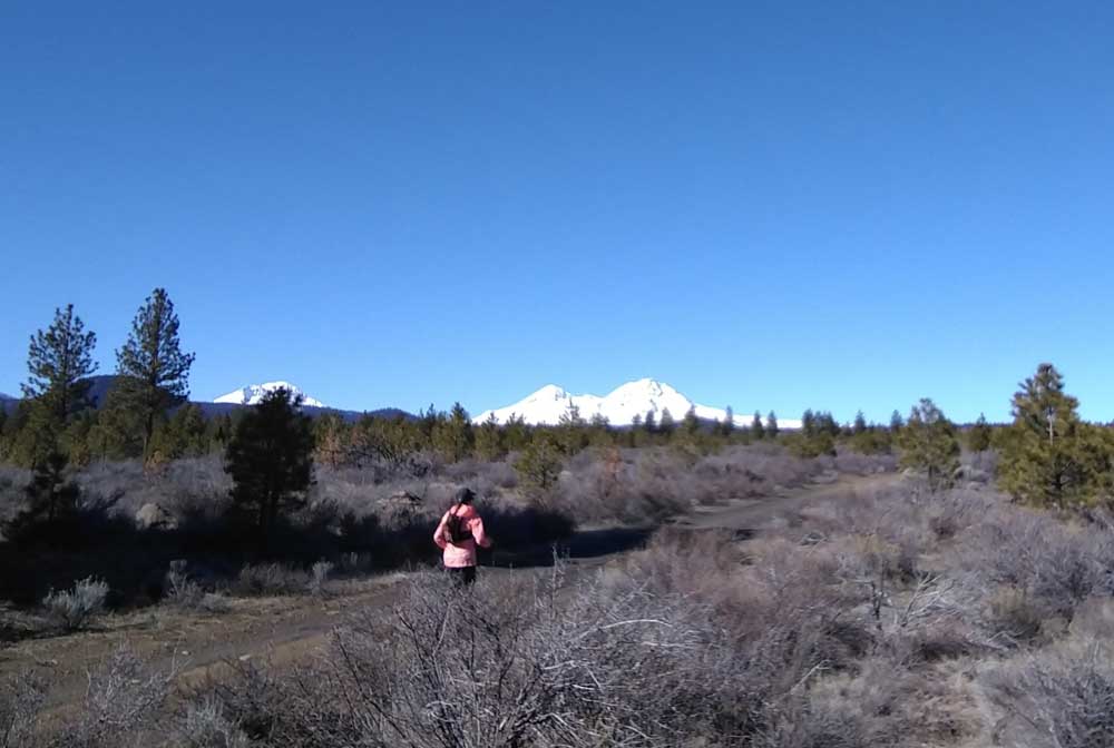
- The old Brooks-Scanlon Logging Road, which connects west Bend to Sisters. It's primetime for a ride, hike or run on the gravel road, which is closed to motor vehicles.
Just outside of Bend to the southwest is the Brooks-Scanlon Logging Road, also known as Forest Road 4606. The gravel route wends about 35 miles to the northwest terminating just outside of Sisters at Indian Ford Campground.
Along the way, it gently climbs hills, cuts through second growth ponderosa pine forest, then opens up to broad views of the mountains. The wide gravel and mellow incline make it a pleasant route for running, cycling, or even a hike with friends.
Trending
The road is within the Tumalo Winter Range Cooperative Closure area and is closed to all motor vehicles. The closure aims to minimize disturbance to wintering mule deer and other wildlife. It is in place until March 31, which makes it prime time to enjoy the area before worrying about getting splattered by mud or dusted when a rig flies by. Keep this in mind though: If you see wildlife along the way, give it plenty of distance. Leave your dog at home to avoid stressing wildlife in the area. Stay on the road and even keep voices down.
The 4606 road is also a good option while snow covers many other areas or trails have variable conditions as the temperatures oscillate between freezing and thawing. Remember, rutting up muddy trails is poor form. It’s hard to ride or run on a deeply rutted trail, so consider others who will come after you when you’re deciding whether to continue on during the spring mud season. This is much less of an issue on a well-established gravel road. Snow also tends to melt faster, especially in the wider sections, where sunlight pours in and douses the area with warmth.
A few locations make good access for an out-and-back on the road. In some spots, the road can be part of a loop connecting trails or other routes for those that are map savvy. Check to make sure that recreating is ok as the area does have a lot of private property adjacent to Forest Road 4606.
From Bend: The Brooks-Scanlon Road originates in what is now Phil’s trailhead, which has a large parking area, so it makes the most sense to access it from there. Head out past the pump track toward Skyliner Road. Brooks-Scanlon Road crosses Skyliner, then curves around and down to cross Tumalo Creek to the west of Shevlin Park. You can also access Brooks-Scanlon Road from Shevlin if you run the Shevlin Road to the end and then head up Lower Mrazek for a short distance.
From Tumalo Reservoir: A number of trails and old two-track roads the Tumalo Reservoir area to the Brooks-Scanlon Road. There is a large dirt pull-off where Tumalo Reservoir Road turns to gravel and becomes Sisemore Road. Cross the open fields of sagebrush toward the trees to the west. From there the Brooks-Scanlon Road climbs a short grade and eventually leads to openings where the mountains come into sight.
From Sisters: From Highway 20 in Sisters, turn left or south onto South Elm Street. About 1.5 miles from town, Brooks-Scanlon Road intersects Forest Road 16 also known as Three Creek Road. There is a wide section of road to the north with places to park. A short walk from there, the road narrows to a footbridge that arcs over Whychus Creek. The Brooks-Scanlon Road is wide and flat in this area which could be great for doing some speed work or running with a group. It feels more developed as it is closer to Sisters and housing developments. South of Three Creek Road, the Peterson Ridge trail network criss-crosses Brooks-Scanlon in several places for anyone looking to mix in some single track.
Trending
From any of these points, the Brooks-Scanlon Road offers long distance routes either through creative connections with other roads and trails or by going out and back. The scenery differs in each direction. Turn around at any point and head back with different views.
Get out there and get some miles.
For more information and a map of the Tumalo Winter Range Cooperative Closure, visit: dfw.state.or.us/maps/travel_management_areas/tumalo.pdf
Marketplace


Best of the Best of Bend 2025

-
eEdition

-

-