Reopened trail section offers Deschutes River access, habitat protection
Published 5:00 pm Thursday, May 11, 2023
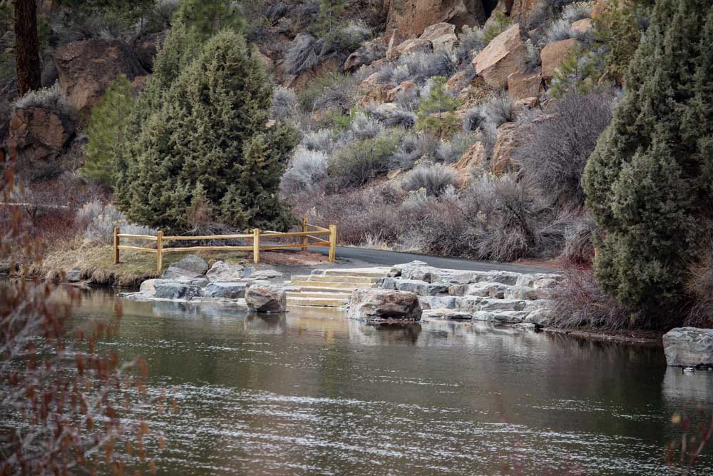
- One of three Deschutes River access points on the Deschutes River near Riverbend and Farewell Bend parks.
If I have a choice, I will always choose a loop for my running route, rather than an out and back. Don’t get me wrong — out and back routes are necessary, especially when you’re exploring a new location or have a time crunch to consider, but I always look forward to new scenery, and loops keep me from cutting a run short.
My favorite loop trail was closed for several months and just reopened — the South Canyon Reach of the Deschutes River Trail. The first time I ran it was during a half-marathon in 2016 on my first weekend as a full-time resident of Central Oregon. While training for the race, I focused on mileage and pace and paid very little attention to surfacing or the amazing beauty that awaited me at the beginning of the racecourse. The memory of that day and many other runs on this 3.5-mile loop on both sides of the river to the south canyon footbridge make me smile, and now I have new sights to enjoy.
Trending
Improved river access, habitat protection
The partial trail closure from October to April was necessary for a recently completed river project by Upper Deschutes Watershed Council and Bend Park and Recreation District. Located on the west side of the river just south of Riverbend Park, there are three new access points for the river and 2,000 feet of split-rail fence to protect the riverbank habitat area that has been overused in recent years. The results are a perfect balance of restoration, protection and access enhancement.
When building access to a river, it can risk looking artificial, but that was not at all the result of this project. These new launching spots and hanging-out areas have boulder terracing and stone entry steps in three locations between the Bill Healy Memorial Bridge and the Farewell Bend pedestrian bridge. The design (aided by help from Oregon Adaptive Sports and Central Oregon Coalition on Access) allows for all users, especially those with mobility limitations, to more easily access the river. Other help made the project happen too — including grants from the Bend Sustainability Fund and Oregon Watershed Enhancement Board. It’s a cool collaboration that will be a blueprint for future projects down river at McKay, Miller’s Landing and Columbia parks.
Alpenglow Park trails are great connectors to the surrounding neighborhoods and there is a loop within the park that is just shy of one mile. It is paved, wide and flat. For a longer trip, you can connect from Larkspur Trail and Central Oregon Historical Canal Trail via 15th Street.
Riley Ranch Reserve trails include 1.57 miles of compacted gravel path and soft-surface trail that navigate in a “figure eight” loop above the canyon, composed of two smaller loops. Juniper Loop, which is connected to the parking lot to the east is .7 miles and connects to the .9-mile Sage Flats Loop. Robin’s Run heads down the canyon rim andlinks to the 1.25-mile Canyon Loop.
Trending
Pine Nursery Park trails include 4.5 miles of interwoven paved trails, including a 1.25-mile paved loop trail. Paved, wide and relatively level, these trails are great for biking, walking and running.
Visit bendparksandrec.org for details and a park and trail locator.
The split-rail fencing will age with time and fade perfectly into the natural area. When you’re up close, you can also see a secondary grid fence installed as a complement. This will keep dogs out while still allowing access for wildlife to get under or over the fence while vegetation fills in and enjoys the break from the trampling.
The closest parking areas are at Riverbend Park and Farewell Bend Park, so pack gear accordingly. For me, this new access looks like a perfect place for a post-run dip in the river. With summer-like temperatures expected this weekend, I invite you to check it out, along with my favorite loop trail.
Marketplace


Best of the Best of Bend 2025

-
eEdition

-

-