Aerial drone ‘sees’ through Flat Fire smoke to lead firefighters to flames
Published 3:45 pm Wednesday, August 2, 2023
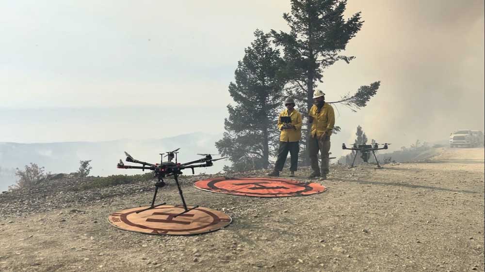
- Pilots prepare to launch an aerial drone to search for hot spots on the Flat Fire earlier this week. Drones, which use infrared heat detection technology, were used Tuesday to direct firefighters toward flames when smoke kept helicopters from flying.
An aerial drone with infrared capabilities was used Tuesday to guide firefighters to spot fires on the far southwest side of the Flat Fire, when helicopters could not fly because of smoke, according to incident commander Dan Quinones.
The fire had charred about 46 square miles as of Wednesday morning, up from about 43 square miles a day earlier. The number of acres burned as of Wednesday was 29,378, up from 27,573 acres a day earlier.
Containment lines now stretch from the Agness area on the north around to the fire’s west side. Agness is on the Rogue River, about 30 miles east of Gold Beach. The fire started about two miles south of town on July 15, at the Oak Flat Campground. The cause is under investigation but has been determined to be human-caused.
The spot fires erupted in a vulnerable spot Tuesday, where firelines were thin, Quinones said.
“That’s the piece that was tested yesterday,” he said. “We had a localized wind shift. It came out, pushed the smoke across the line and we actually picked up a few spot fires just outside of that.
“With smoke laying over the line, we couldn’t get helicopters in there to do air support. Having that [infrared technology], with that Type 3 drone that we had on site, was walking those firefighters — it could see through the smoke — it walked them right to it.”
Six small fires erupted, the largest at 20 feet by 100 feet. Firefighters quickly contained them.
Quinones said the situation was “a little test,” and predicted more tests ahead, as weather warms and seasonal winds possibly pick up out of the east later in the month.
“We’re looking forward to more activity here in the near term,” he said. “The middle of August is going to be the peak, as we all know.”
East winds would tend to push flames toward coastal communities. Gold Beach is 11 miles to the west.
In other news from the fire, the percent of firelines considered strong enough to keep fire from crossing them rose to 28% as of Wednesday, up from 14% a day earlier, according to Quinones.
“We’ve doubled our containment percentage,” he said. “So, good jump there. That’s good, hard black, making sure that’s not going to escape any containment lines.”
Burnouts have been used to blacken the landscape, strengthen firelines and deny the main fire of fuel. Burnouts are deliberately set low-intensity fires intended to burn woody debris near the forest floor.
Quinones said he was most concerned about the fire’s southwest side, but was pleased with progress.
“Our priority is down here,” he said, indicating that sector. “We got a lot more depth, a lot more security on that line that we’ve been trying to get.”
On the fire’s northeast corner, things also heated up on Tuesday, prompting the use of helicopters to drop water on spot fires.
“Helicopters jumped on that real quick and made sure that stayed in check,” Quinones said. “We’re going to keep that checking action going with helicopters to make sure that we can keep this fire small and keep it parked where it’s at to the best of our ability.”
The number of personnel assigned to help fight the fire was 1,419 on Wednesday morning, down from 1,941 on Sunday.
The number of firefighters injured on the fire stood at 25 as of Wednesday, according to Oregon Emergency Management. None of the injuries were serious, according to Lauren Durocher with Northwest Fire Management Team 3.
The estimated cost to fight the fire was $40 million as of Wednesday, according to National Interagency Fire Center, although Durocher said her information had the estimated cost at $31.9 million.


Best of the Best of Bend 2025

-
eEdition

-

-