El Niño brings warmer temperatures, rain to Central Oregon
Published 5:45 am Wednesday, December 13, 2023
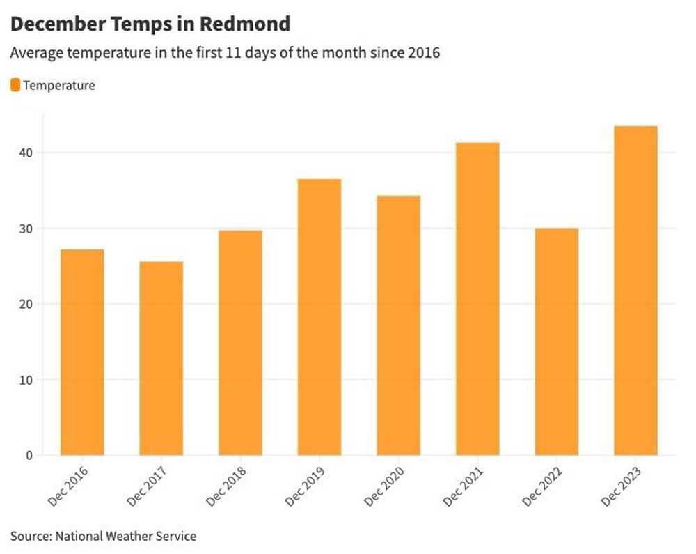
- redmond temps
El Niño is upon us and so far the weather is doing just what it normally does in Oregon: deliver high temperatures and not much snow.
When precipitation did arrive this month, it came mainly in the form of rain at lower elevations. Higher elevations have received snow, but warm weather and periodic rain have melted off much of the accumulation.
Snowpack in the Upper Deschutes and Crooked River basin as of Tuesday was 75% of normal. Temperatures, as measured at Redmond Airport, are 10 degrees higher than the December average of 33.6 degrees, according to data from the National Weather Service.
“Central Oregon has experienced much drier and warmer weather than normal weather since Oct. 1, which is what we expect during a strong El Niño year,” said Larry O’Neill, the state’s climatologist and an associate professor at the Oregon State University College of Earth, Ocean, and Atmospheric Sciences.
Very strong El Niño possible
What happens next for the winter is always a guessing game, but scientists have tools to predict what could be in store for the region. Climate models currently show a 35% chance that this El Niño intensifies from strong to very strong, said O’Neill.
El Niños that fall into the very-strong category have occurred just three times since 1950. Strong El Niños occur when ocean surface temperatures in the east-central Pacific rise 2.7 degrees while a 3.6 degree increase indicates a very strong El Niño.
If the El Niño intensifies, Central Oregon can expect the wetter and warmer than normal conditions to continue, said O’Neill.
“We can also expect normal snow at higher elevations, but the forecast of warmer-than-normal conditions will not favor the snowpack to persist,” he said.
Above average temps
The high temperatures have brought fog and rain to Bend, conditions that look more like winter in Portland or Seattle. The average temperature in December at the Redmond Airport this December is 43.5 degrees through Monday. That is well above the 30-degree average for the same time period a year ago.
Precipitation is better than average for the water year, which began Oct. 1. Since that date, the Upper Deschutes Basin is 108% of normal.
“On the whole, given what we are expecting, it’s going to be below-normal snowpack and above-normal precipitation in Central Oregon,” said Tom Schuldt, a meteorologist with the National Weather Service office in Pendleton.
While the historical tendency is for warmer temperatures and lower snowpack, each El Niño is different from the last.
“There is variability among past strong to very strong events,” said Matt Warbritton, supervisory hydrologist with the Natural Resources Conservation Service. “For example, during the last very strong El Niño in 2015, precipitation was near normal while snowpack was well-below normal. During a very strong El Niño in 1997, both precipitation and snowpack were above normal.”
Based on seasonal outlook reports from the National Oceanic and Atmospheric Administration, Warbritton said the likelihood is high for continued warmer temperatures and lower snowpack.
Last year, Central Oregon received above-average snowfall, especially late in the season. O’Neill said that was partly attributable to La Niña, a weather phenomenon that has the opposite effect of El Niño.
During a La Niña event, warm water in the Pacific is pushed toward Asia, causing an upwelling of cold water in the eastern half of the Pacific. The cold water pushes the jet stream northward, bringing moisture and cold weather to the Pacific Northwest.
“The persistent cold weather all of last winter and spring was exactly what we generally expect from a La Niña, even a weaker one,” said O’Neill.
Skiers await the snow
Ski areas are holding out hope that this El Niño can be another anomaly, with decent snow and colder temperatures to come.
Mt. Bachelor ski area west of Bend got off to a strong start when it opened in blizzard conditions earlier this month, but rain quickly melted away some of the snow. As of Monday, the resort had four chairlifts operating.
Lauren Burke, a spokesperson for Mt. Bachelor, said snow-making operations are underway to improve conditions on the slopes and a little more natural snow will help to open more parts of the mountain.
“We are working towards opening the all-new Skyliner Express and our beginner terrain at Alpenglow and Early Riser next but will need some help from Mother Nature in order to open additional terrain,” said Burke.
“We of course want as much snow as we can each early season, but as we all know, we can’t control the weather.”
Hoodoo Ski Area northwest of Sisters has not set an opening date. Matt McFarland, general manager, said three snowstorms this season have dropped several feet of snow but most of it melted away with the warm temperatures. Hoodoo currently has around 10 inches of accumulation.
“If it had stayed, we could have opened,” said McFarland. “But with the warm temperatures and rain, it just keeps taking out the snowpack. We are seeing the same thing throughout the region.”
Hoodoo has 150 staff members who have gone through seasonal training and are now waiting for the resort to open so they can get to work, said McFarland. For now, everything is on hold.
“It will come eventually. We just hope eventually is soon,” McFarland said.
While the conditions aren’t great, ski shops are still doing brisk business, renting equipment to folks who don’t mind the limited chairlift options at Mt. Bachelor.
“We have enough to ski on now and that is good enough for most people. And everyone that has been coming down has been having a great time,” said Todd McGee, owner of Powder House Ski & Snowboard in Bend since 2000.
“The stoke level is pretty high.”
More Bend


Best of the Best of Bend 2025

-
-
-