Central Oregon outdoors and trail conditions
Published 3:30 pm Thursday, December 21, 2023
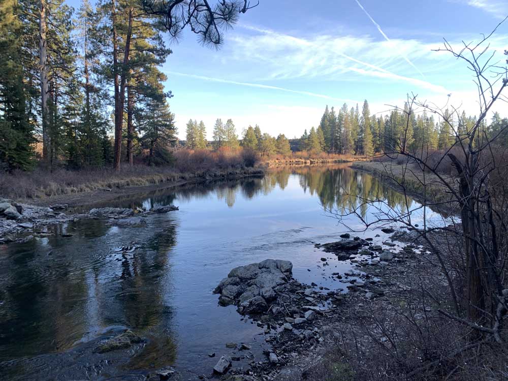
- A mountain bike loop ride departing from Aspen Day Use Area to Sunriver and back affords plenty of opportunity to catch views of the Deschutes River.
Happy winter and welcome to longer days from here on out. Most winter recreation appears to still be on hold. Although there’s a chance of snow today and later in the week, the weekend forecast remains dry with temperatures dropping into the mid-30s during the day — fine hiking and biking weather, especially if the sun is out.
Based on what Deschutes National Forest trail crew supervisor Joe Welke said last week, and the dry weather this past week, most sno-parks do not have adequate snow coverage for winter activities. However, the new Skyliner express chairlift at Mt. Bachelor ski area opened Tuesday, so take the opportunity to head up for some groomer laps with the family. When the snow finally does come, remember to pick up a permit before heading out to the sno-parks.
For a full list of conditions updated regularly, visit bendbulletin.com/explore/conditions.
Hiking and Day Use Sites
Deschutes National Forest
- Aspen Day Use: Open
- Benham East Trailhead: Open
- Benham West Trailhead: Open
- Besson Day Use: Open
- Big Eddy Day Use: Open
- Black Crater Trailhead: Open; snow likely near summit
- Broken Top Trailhead: Open; likely snow
- Cabot Lake Trailhead: Open; snow free and clear from trailhead to point 1.25 miles past Cabot Lake, heavy blowdown beyond
- Charlton Lake Trailhead: Open; snow
- Chush Falls: Open; snow free and clear
- Crane Prairie Picnic Area: Open
- Crater Ditch Trailhead: Open; Forest Road 370 is closed
- Cultus Lake and Winopee trails: Open; likely snow, with moderate downfall between lakes
- Deer Lake Trailhead: Open; snow
- Dillon Day Use: Open
- Dutchman Trailhead: Open
- Edison Trailhead: Open
- Irish and Taylor Lakes Trailhead: Open
- Lava Island Day Use: Open
- Lava Lake Day Use: Open
- Lemish Lake Trailhead: Open; likely snow
- Little Fawn Day Use: Open
- Lucky Lake Trailhead: Open; likely snow
- Many Lakes Trailhead: Open; likely snow
- Meadow Picnic: Open
- Meek Lake Trail: Open
- Meissner Trailhead: Open
- Metolius-Windigo: Open
- Millican Crater Trailhead: Open; possible snow
- Moraine Lake: Open
- North Twin Boating Area: Open
- Park Meadow: Open
- Phil’s Trailhead: Open; trail closures include Voodoo between Ben’s and Phil’s, lower Ben’s, Kent’s and mountain bike trails on weekdays
- Pole Creek Trailhead: Open; snow likely about 4,500 feet
- Quinn River Boating site: Open
- Rimrock Trailhead: Open
- Rosary Lakes Trailhead: Open
- Scott Pass Trailhead: Open; possible snow
- Simax North and South Beach area: Open
- Summit Lake: Open; Partially cleared, possible snow
- Swampy Lakes Trail: Open; possible snow
- Tam McArthur Rim Trailhead: Open
- Tandy Bay Picnic Area: Open
- Todd Lake Trailhead: Open; do not trample restoration areas; possible snow
- Tranquil Cove Day Use: Open
- Tumalo Falls Trailhead: Open; Road to Tumalo Falls closed for the season; blowdown on Swampy Lakes Trail and upper portions of Bridge Creek
- Tumalo Mountain: Open, possible snow
- Wake Butte Trailhead: Open
- Wanoga Trailhead: Open; Tyler’s Traverse closed between Kiwa Spring Road and the trailhead
- Wickiup Plains Trailhead: Open
- Wyeth Boating Site: Open
Deschutes National Forest — Diamond Peak Wilderness
- Crater Butte Trailhead: Open
- Fawn Lake Trail: Open
- Snell Lake Trail: Open
- Whitefish Creek Trail: Open
- Yoran Lake Trail: Open; likely snow
- Stag Lake Trail: Open
Willamette National Forest — Three Sisters Wilderness Area
- Patjens Lake Trail: Open
- Tamolitch Blue Pool: Open
Willamette National Forest — Diamond Peak Wilderness
- Bear Mountain Trail: Open
- Blue Lake Trail: Open
- Corrigan Lake Trail: Open
- Diamond Peak North: Open
- Diamond Peak South: Open
- Diamond Peak Tie: Open
- Happy Lake: Open
- Hemlock Butte Trail: Open
- Marie Lake Trail: Open
- Mt. Yoran Trail: Open
- Pioneer Gulch Trail: Open
- Rockpile Trail: Open
Willamette National Forest — Waldo Lake Wilderness Area
- Abernethy-Deer Creek Trailhead: Open
- Betty Lake Trailhead: Open
- Black Creek Trail: Open
- Bobby Lake Trailhead: Open
- Bunchgrass Trailhead — Lower: Open
- Bunchgrass Trailhead — Upper: Open
- Cupit Mary Meadow Trail: Open
- Devil’s Garden Trailhead: Open
- Fuji Mountain Trailhead at Gold Lake: Open
- Gold Lake Day Use Area: Open
- High Divide Trailhead: Open
- Jim Weaver Loop Trailhead (Waldo Lake Trail): Open
- Marilyn Lakes Trailhead: Open
- Mt. Ray Trailhead: Open
- Rigdon Lakes Trail: Open
- Verdun Trailhead: Open
- Wahana Trail: Open
Ski areas and sno-parks
Updated 9 a.m. Dec. 20
- Mt. Bachelor: Open; 23-inch base; New Skyliner chairlift opened Tuesday
Updated 9 a.m. Dec. 14
Deschutes National Forest
- Crescent Lake Sno-park: Open; low snowpack, 2-6 inches
- Crescent Junction: Open; low snowpack, 2-6 inches
- Edison Butte Sno-park: Open; low snowpack, 1-4 inches Snow shelter closed for public safety
- Kapka Butte Sno-park: Open; low snowpack, 4-8 inches
- Meissner Sno-park: Open; low snowpack, 1-4 inches; No grooming yet
- Skyliners Sno-park: Open; low snowpack
- Swampy Sno-park: Open; low snowpack, 3-6 inches; Warming hut on site
- Vista Butte Sno-park: Open; low snowpack, 4-8 inches
- Wanoga Snow Play: Open; low snowpack, 1-5 inches
- Wanoga Snowmobile: Open; low snowpack, 1-5 inches
- Newberry (Six Mile Sno-park): Open; No snow
- Newberry (10 Mile Sno-park): Open; low snowpack, 2-6 inches
- Three Creek Sno-park (Lower): Open; No snow; Designed as overflow lot, not plowed regularly
- Three Creek Sno-park (Upper): Open; No snow
- Walt Haring Sno-park: Open; low snowpack, 0-4 inches; Warming hut on site
Willamette National Forest
- Gold Lake Sno-park: Open; low snowpack; Warming cabin on site, ski shelters in area
- Ikenick Sno-park: Open; low snowpack
- Little Nash Sno-park: Open; low snowpack
- Maxwell Sno-park: Open; low snowpack; Mountain View Shelter accessible from trails
- Potato Hill Sno-park: Open; low snowpack
- Ray Benson Sno-park: Open; low snowpack; warming hut, concessions nearby at Hoodoo
- Salt Creek Sno-park: Open; low snowpack; Fuji Shelter accessible from trails
- Santiam Sno-park: Open; low snowpack; Access to Pacific Crest Trail
- Waldo Lake Sno-park: Open; low snowpack
Camping
Deschutes National Forest
- Devils Lake Campground: Open
Cycling
Phil’s Trail Complex
The following temporary trail and road closures are in place on Mondays starting at midnight through Fridays until 3 p.m. to protect the public’s safety as thinning and fuel reduction work continues:
- Ben’s and Kent’s trails will be closed from the start at Phil’s Trailhead west to the junction with KGB Trail, Ben’s connector (Jct. 5) to Skyliner Road is also closed
- Voodoo Trail will be closed from the northern junction with Ben’s south to the junction with Phil’s Trail
- MTB Trail will be closed from the junction with Ben’s south to the junction with Kent’s Trail
- Skills area is open
- All other trails riding well
Wanoga Trail Complex
- Dinah-Moe Humm: Rideable snow
- Deschutes River: Variable
- All other trails riding well
North of Skyliner trails
- Northfork: Muddy
- Upper Mrazek: Rideable snow
- All other trails riding riding well
Swampy Lakes trails
- Flagline Access, Flagline Tie, Lower Flagline, Met-Win — Flagline to Happy Valley, Middle Flagline, Swampy/Dutchman, Upper Flagline, Vista Butte: Deep snow
- Tumalo Ridge, Sector 16: rideable snow
- Swede Ridge: Variable
- All other trails riding well
Cascade Lakes trails
- All trails in Deep Snow
Mt. Bachelor
- Bachy West XC: Deep snow
- All other trails need reports
Sisters trails
- Green Ridge: Sandy/Loose
- Metolius Windigo (99 Upper): Variable, likely snow
- All other trails riding well
Waldo Lake Region
- Betty Lake, Charlton Lemish Loop, Clover Meadow No. 21, Leap of Faith, Moore Creek: Needs report
- Charlton Lake No. 3593: Sandy/Loose
- All other trails riding well
Cascade Crest
- Swamp Peak: Variable
- Bachelor Mountain, Browder Ridge, Bruno Meadows, Bugaboo Ridge, Coffin Lookout, Gate Creek, Gordon Meadows, Heart Lake, Santiam Wagon: Needs report
- All other trails riding well
McKenzie Region
- Frissell: Needs report
- All other trails riding well
Fishing
Updated at 10 a.m Dec. 21
- McKenzie River (at Clear Lake): 538 cfs
- McKenzie River (near Belknap Springs): 1,220 cfs; rainbow and coastal cutthroat trout; fire cleanup still being conducted in the area, access may be limited; all nonadipose fin-clipped trout must be released; lures and artificial flies only
- North Twin Lake: Rainbow trout; open to fishing all year
- South Twin Lake: Rainbow trout; open to fishing all year
- Davis Lake: rainbow trout and largemouth bass; fair fishing for largemouth bass; fly fishing only; fair fishing, catch and release for trout, no limit on size or number for warmwater fish
- Lava Lake: Rainbow trout; recent reports of good fishing; open to fishing all year, Cascade Lakes Highway is closed for season
- Little Lava Lake: Rainbow trout, brook trout and whitefish; best methods are bait, lures and flies still-fished or trolled; Cascade Lakes Highway is closed for season
- Cultus Lake: Mackinaw, rainbow and brook trout; troll depths for mackinaw and shallower areas for rainbows; Cascade Lakes Highway is closed for season
- Elk Lake: Brook trout and kokanee; jigging, still-fishing and trolling from a boat or fly fishing are best; Cascade Lakes Highway is closed for season
- Diamond Lake: trout; all brown and tiger trout must be released; trout fishing has been good on lures; if you catch one over 20 inches, take it to the marina to be entered for a raffle
- Crescent Lake: 10% full; kokanee, mackinaw, rainbow and brown trout, whitefish and chub; lake level is low and developed boat ramps are unavailable for launching boats, one lake trout per day, 24-inch minimum length
- Waldo Lake: Boating restricted to electric motors or non-motorized vessels
Fire danger is currently listed as Moderate in the Ochoco National Forests, the Crooked River Grasslands. The Deschutes National Forests and Willamette National Forests fire danger is low.
Industrial Fire Precaution Level has been lowered to 1 as of Sep. 20 in the Deschutes, Ochoco and the Crooked River Grasslands and the Willamette National Forests.
As of July 22, 2020, Deschutes River access is closed due to safety concerns and to prevent further erosion to the riverbank. The access point will be closed until further notice. For more information visit bendparksandrec.org
• The Monument Area will be open to climbing beginning July 7, 2023.


Best of the Best of Bend 2025

-
eEdition

-

-
Go! eEdition