El Niño weather leaves many Central Oregon trails open for hiking
Published 5:45 am Friday, December 29, 2023
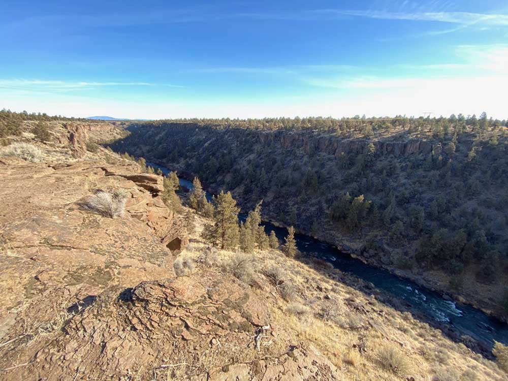
- The sun can’t quite reach the Deschutes River at the bottom of the canyon along the Rockbar portion of the Maston Trail Complex in this November 2020 photo.
Thanks to a stubborn, warm El Niño cycle, dry Central Oregon trail options exist for the 2023 holiday season. Here’s a handful of bite-sized options that you can treat out-of-town relatives to without requiring snowshoes:
Maston Trail System
A secret to no one, the Maston Trail System (technically a part of the Redmond trails network and maintained by the Central Oregon Trail Alliance) has become one of the top wintertime destinations for mountain bikers. The magic of the microclimate of Maston is that when Bend and Sisters get 3 inches of snow, Maston often receives a mere dusting. What’s more, for the two-wheeled enthusiasts, winter’s freezing temps create frozen mud and pumice, resulting in a tacky, delightful surface that provides smooth travel to breathtaking views of the Deschutes River hundreds of feet below a sheer canyon. Maston Trailhead is about 7 miles southwest of Eagle Crest Resort, and well-signed just east of Cline Falls Highway.
Trout Creek Conservation Area
Bordering the northwest corner of Sisters, Trout Creek Conservation Area is owned by Sisters High School with partnership from the Deschutes Land Trust. The shortest trail system on this list, it runs barely a mile from Sisters High School soccer fields to the Tollgate Neighborhood just north of Sisters. It has become a sanctuary for the rare Peck’s penstemon, a flower that grows only in Central Oregon, and for whom 10% of its global supply exists in the 161 acres at Trout Creek.
In addition to the insanely rare plants, it is home to numerous families of deer, the white-headed woodpecker, and probably too many of the neighborhood’s domestic canines. Even high school cross country competitors can be spotted circling the area in the fall. Trout Creek itself is a bit of a mystery, materializing after heavy snowfall semi-annually underneath pedestrian bridges constructed in 2019. From downtown Sisters, take U.S. Highway 20 north barely a mile to Mckinney Butte Road, and turn west toward Sisters High School. The trail begins at the northeastern edge of the school’s property.
Meissner Nordic waiting for enough snow to reopen for skiing
Whychus Creek Trail
If the Trout Creek trail hasn’t satisfied your itch for a walk in the woods, the Whychus Creek Trail certainly will. With a maximum of 6.4 miles and around 500 feet of elevation gain/loss, it will increase your cardiovascular capacity without leaving you winded. In other words, it’s a great weekend warrior hike. The trail meanders through towering snags burned during the Pole Creek Fire of 2012, and below craggy rocks and boulders next to raging rapids. You can make a true meal out of the hike by going up to Upper Chush Falls, or you can keep your Sunday School outfits clean with a brief, 1-mile, out-and-back stroll up to the Whychus Creek Scenic Overlook. The trailhead is 4.3 miles south of Sisters on Three Creeks Road.
Cascade View Trail System
One of the newer trail complexes in Central Oregon, the Cascade View Trail System is part of the larger Cline Buttes Recreation Area, where hikers, bikers and horseback riders compete for breathtaking views of the Three Sisters, Black Butte and just about anything else you want to see at points west of Redmond. The trailhead is off of Eagle Crest Boulevard, which juts south of Highway 126 between Sisters and Redmond. This area has historically been home to grazing cattle and the numerous gates prove this (make sure to close them behind you).
Twin Bridges Road
A mile or two northeast of Tumalo lies a longtime whispered-about favorite for local runners, walkers and dog owners. Twin Bridges “park” is not actually a park, but a strip of private property running adjacent to the Deschutes River. The trail is accessible to the public thanks to the generosity of the property owners. Only well-behaved hikers and runners are invited to enjoy the 3.5-mile out-and-back sojourn that provides views of natural and artificial wonders galore. A historic farm building, a wooden pedestrian bridge and a beautiful, rocky gorge comprise the diversity of sights along the mostly flat and well-trod dirt trail that hugs the shore. There are spurs off the trail leading to the top of a small butte, but wandering past the barbed wire would be an ill-advised trespass. So, too, would be recklessly ignoring leash rules, though pooches are often found bathing in the river at a few of the small beaches along the way. From Tumalo, it can be reached via Tumalo Road, to a northward turn on Swalley Road, and a westward turn on Twin Bridges Road, where a bridge marks the trailhead. Parking is limited to the roadside, so try and carpool.


Best of the Best of Bend 2025

-
-
-