Blizzard alert issued for Central Oregon, with snow in the forecast in Bend and beyond
Published 9:43 am Monday, January 8, 2024
- snowstorm
Batten down the hatches Central Oregon.
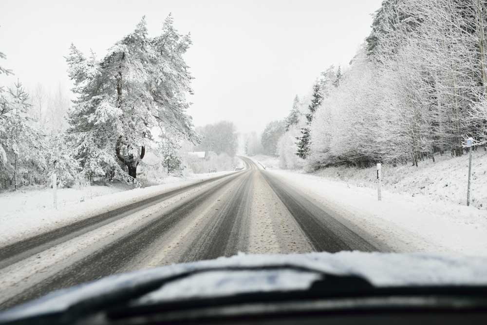
Snow and high winds are forecast for much of this week, bringing much-needed snowpack for the mountains, but also challenging travel conditions for those venturing on the roads.
A blizzard warning is in effect for the eastern slopes of the Cascades from 4 a.m. on Tuesday until 4 p.m. on Wednesday, according to the National Weather Service. La Pine and Sunriver are in the path of the blizzard while Bend, Sisters and Redmond will be under a winter weather advisory.
Travel could be difficult to impossible, the National Weather Service warns, with widespread blowing snow reducing visibility to less than a quarter mile. Strong winds with gusts up to 60 mph could also cause trees to fall.
Travel warning
During the blizzard alert, the public is advised to restrict travel to emergencies only. Those who do use the highways for travel are advised to bring a winter survival kit, extra food and warm clothing. Stranded travelers are advised to stay with their vehicles.
Hoodoo Ski Area expected to open Wednesday
David Abbas, the director of Bend’s Transportation and Mobility Department, said snowplows typically get on the road by 4 a.m. on snowy days but can operate 24 hours a day as needed. The city has 30 snowplows and other equipment for sanding and de-icing roads.
“Give yourself plenty of time and slow down,” said Abbas. “If the storm is bad and you don’t need to be out there, don’t be out there.”
Wild weather may not be the only obstacle to travel as high winds can create hazardous conditions. On Monday, Pacific Power advised the public to stay away from downed utility equipment.
“Even if the lines are not sparking, they could be energized and extremely dangerous,” the utility said in a statement. “Customers should avoid both downed trees and power lines as well as keep pets far away from those areas.”
La Pine and Sunriver are expected to receive 1-3 inches of snow on Tuesday followed by 7-9 inches overnight by Wednesday morning, said Colby Goatley, a meteorologist with the National Weather Service office in Pendleton.
Bend is forecast to receive less than an inch of snow on Tuesday and 4-6 inches overnight by Wednesday morning, with the heaviest snow falling on the southwest side of town. Sisters could receive 6-8 inches and Redmond 2-3 inches in overnight snowfall.
Snow on the passes
The mountain passes could receive significantly more snowfall said Goatley, with 2 to 3 feet of snow accumulating on Santiam Pass on Tuesday and Wednesday. Up to 4 feet is possible, he said, although less likely. More snow is expected to hit the area even after Tuesday’s blizzard conditions subside.
“Multiple systems are going to bring snowfall for the rest of the week and into the weekend,” said Goatley.
Santiam Pass is forecast to receive another 6-12 inches of snow on Thursday and higher elevations will see 2 feet of snow.
“Into Sunday things start to taper off, and then high pressure on Monday should relax conditions for a period. Monday should be a brief respite,” said Goatley.
Good news for snowpack
The snow is good news for ski area and snow-sports enthusiasts. So far this winter, snowpack has been paltry, with levels that are just half of normal. Higher elevations could see up to 4 feet of snow, which may bring snowpack back to normal levels for the season.
Deschutes basin snowpack less than half of normal
“We should see some significant snowpack recovery if the forecasted amounts of snow do indeed come to fruition,” said Matt Warbritton, supervisory hydrologist with the Natural Resources Conservation Service.
Ski areas that haven’t opened yet are expected to do so this week. Hoodoo Ski Area plans to open on Wednesday and Mt. Hood Skibowl will open on Thursday, according to announcements made separately by each.
Presley Quon, a spokesperson for Mt. Bachelor ski area, said expected conditions will likely limit operations to lower mountain lifts.
“Our teams will assess the conditions as the storm plays out, and we will keep guests informed as we know more,” she said.
- Secure garbage barrels and other loose outdoor objects that may blow away in high winds.
- Avoid unnecessary travel.
- If you must travel, visit tripcheck.com for driving conditions, alerts and webcam footage of roads.
- Depart early and plan for delays. A crash or fallen tree can close a road for hours.
- Carry tire chains and check their usability before leaving town.
- Never pass a snowplow on the right. Snow is being plowed to the right side of the road.


Best of the Best of Bend 2025

-

-
-