Winter storms boost Central Oregon snowpack to normal levels for the season
Published 5:45 am Wednesday, January 17, 2024
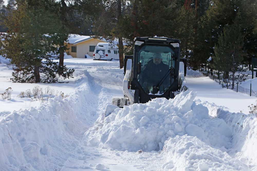
- Matthew Coats, owner and operator of Cascade Land Development, uses a Bobcat to clear snow Monday afternoon from a client's driveway in Bend.
At the end of December, some were wondering if Central Oregon was headed for a snowless winter.
Not anymore.
The series of powerful winter storms that tore across the Pacific Northwest over the past week dumped up to 5 feet of snow in the Cascades, delighting skiers and bringing renewed hope that drought levels could subside.
As of Tuesday, snowpack in the Upper Deschutes and Crooked River basin was 96% of normal, a significant turnaround from the first day of the year when the snowpack was just 37% of normal.
The near tripling of snowpack occurred mostly last week, as snowstorms rolled through Central Oregon in multiple waves. The first to hit on Jan 9-10 closed Bend-La Pine Schools and Oregon State University-Cascades for a day. A second storm brought another wave of heavy snow on Saturday, creating havoc on the roads and delaying delivery trucks from Portland. Many people spent the holiday weekend digging out driveways and sidewalks.
Operations at Mt. Bachelor and Hoodoo ski areas were inconsistent, with lifts running mainly at lower elevations or closed completely.
“These storms are a welcome deviation from the snow drought conditions we were seeing at the start of January,” said Matt Warbritton, supervisory hydrologist with the Natural Resources Conservation Service. “Statewide snowpack was approaching record lows on Jan. 1 with several sites in the Central Cascades measuring record or near record low snowpack.”
Since then, data from the agency shows early January has been one of the snowiest on record, with more than 5 feet accumulating in some areas.
As of Sunday, totals for the month included 70 inches at the McKenzie site, 30 miles northwest of Bend; 68 inches at Mount Hood and 62 inches at the Irish Taylor site near Cultus Lake. The numbers are a substantial turnaround from December when these same sites had 8 inches or less of snow.
“The snowstorm has been amazing for the Cascades in no part because of how bleak the snowpack situation was coming into January,” said Larry O’Neill, an associate professor at the Oregon State University College of Earth Ocean and Atmospheric Sciences.
Bend — which had received mostly rain so far this winter until the recent storms — experienced a range of snow totals over the past week. A station on Bend’s west side received 20.6 inches between Jan. 8-13, according to the National Weather Service.
Measurements taken in central and southern Bend were 18 inches during the same period, while Bend’s northern outskirts received 7 inches.
The snow came with bitterly cold temperatures that prompted freeze warnings across the region. Temperatures in Bend ranged between minus 4 and minus 7 degrees on Saturday.
Redmond was close to breaking a record low for Jan. 13 with minus 3 degrees, but the record remains at minus 5, which was set in 1949. The low in Redmond was minus 1 degree on Sunday, breaking the previous record for that date of 1 degree, set in 2013.
The snow totals could continue to improve this week. Five to 9 inches of snow are forecast to fall by the end of Wednesday, according to Cole Evans, a meteorologist with the National Weather Service office in Pendleton.
The fresh blanket of snow has been a blessing for ski areas that struggled through December. Ski shops and other businesses that depend on winter tourism have also gotten a lift.
“We rely on snow to start leading many of our tours,” said Courtney Braun, owner of Bend-based Wanderlust Tours. “Once November hits, I find myself constantly refreshing my NOAA weather tab on my computer to see when we think we will be able to start guiding snowshoe tours.”
Braun said in previous years Wanderlust has started snowshoeing trips as early as October.
“This year we were not able to run any snowshoe trips in November, having to cancel many reservations due to a lack of snow,” said Braun. “We had some luck in December, but we were still slow. Folks felt like there just wasn’t enough snow.”
Since the recent storms, Braun said her team has been busy breaking trails for clients to get into the wilderness.
“It created an incredible amount of work for our guides,” said Braun. “Now that we have a good base of snow, bookings will continue to improve.”
Despite the healthy snowpack totals, O’Neill cautions that a return to warm conditions and weak snowpack is still in the cards due to the El Niño weather pattern.
“We expect after this cold interlude to return to warmer-than-normal conditions,” O’Neill said. “El Niño impacts on our weather are best evaluated over the course of a season, and one large storm such as this is not surprising during an El Niño.”
Oregon Snowpack
Snowpack in Oregon basins as a percentage of normal, as of Tuesday.
Owyhee: 135%
Malheur: 116%
Grand Ronde, Powder, Burnt, Imnaha: 77%
Umatilla, Walla Walla, Willow: 83%
John Day: 103%
Upper Dechutes, Crooked: 96%
Hood, Sandy, Lower Deschutes: 95%
Willamette: 109%
Rogue, Umpqua: 101%
Klamath: 91%
Lake County, Goose Lake: 90%
Harney: 136%


Best of the Best of Bend 2025

-

-
-