Of the buttes around Bend, Lava is a beauty
Published 5:45 am Friday, February 9, 2024
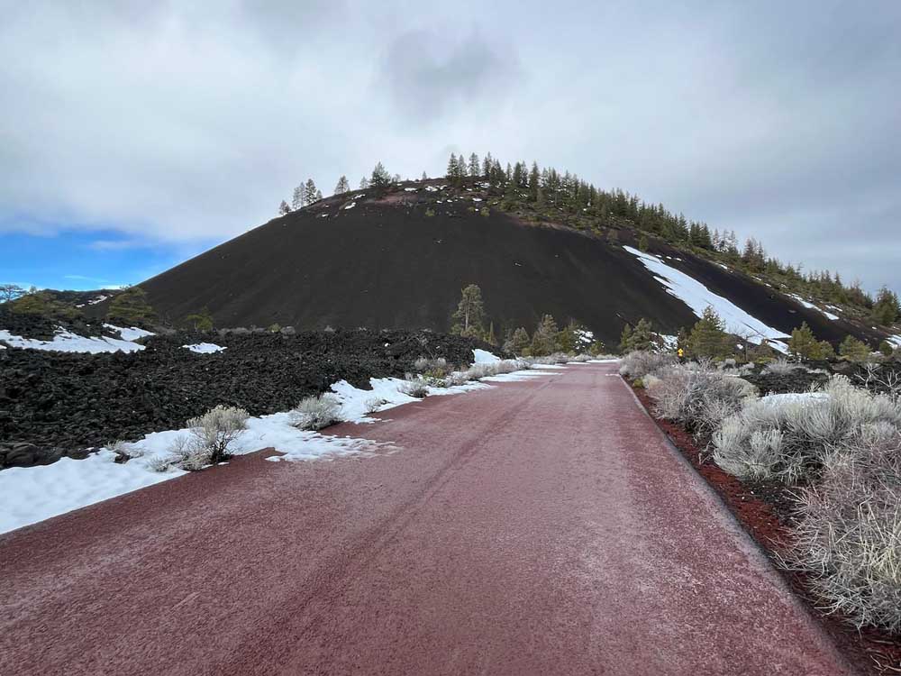
- The 500-foot cinder cone Lava Butte looms large between Sunriver and Bend.
Hike up any of the buttes around Bend, and you’ll be well-rewarded with a twofer of lung-and-leg-strengthening exercise and fantastic big-bang-for-your-buck vistas worthy of tourism brochures.
Amazingly, and lucky for us, there are almost zero needy social media influencers marring the views from our dormant lava domes and cinder cones.
Trending
The best known of the big bumps above and beyond Bend is probably Pilot Butte, a 4,142-foot cinder cone poised smack in the middle of Bend’s east side. Pilot Butte is visible to anyone who has driven on Highway 20 through Bend, as well as from the Bend Parkway and enough neighborhoods that it;s the site of Bend’s annual July 4th fireworks display, which occasionally triggers fiery spectacles given its scruffy landscaping. Hikers, runners use the wrap-around trail to the top, as well as the road paralleling it, on which cyclists can be seen pedaling up. In summer, the road is a draw for autos (or their drivers) when the road to the summit is open, as well as a popular destination for those seeking cardio.
Lesser known is Overturf Butte, on Bend’s west side, an almost-hidden gem that provides great views of its own, albeit from a lower height. The trail to the top, accessible from Overturf Park, leads to rocky outcroppings. Be warned, it’s pretty much surrounded by houses on two sides, but Overturf also makes a good jumping-off (not literally) point to Phil’s Trailhead via the Cascade Highlands Trail.
A hike up Overturf Butte affords a view of Bend life
Bessie Butte, located a few miles out China Hat Road, is about 1.4 miles round trip and has become increasingly popular with hikers — especially in winter, when its sandy trail, another spiraling path, firms up. (Beware the possibilities of well-trod snow and ice on its shaded northern flank.) Catch Bessie on a clear day, as my wife and I did last weekend, and you will be well-rewarded with stellar views of Mount Jefferson and Mount Hood, and of course our nearer neighboring peaks, such as South Sister and Broken Top.
Trending
But that’s likewise true of Lava Butte, a cinder cone located about 10 miles below Bend’s south end. One could easily make the case that Lava Butte is the crown jewel of those the Bend area has to offer.
Part of Newberry Volcanic National Monument, it stands 500 feet above Lava Lands Visitor Center, and is located about 7 miles north of Sunriver, and just 10 miles below the south end of Bend, making it a quick jaunt on Highway 97 from either direction. Lucky Sunriverians — Sunriverers? — can even use the Sun-Lava Paved Path for an even more direct route and more exercise.
Maybe it’s because we hike Bessie a few times a month, but my wife and I tend to visit Lava Butte only about once a year. And every time we do make the drive to hike, I’m struck by two things:
First: As we walk the flat quarter mile from the parking area to its base, I marvel at how amazing it looks in stark contrast to the pines and sprawling lava field below it, which also offers paved paths worth exploring.
Second: Good lord this road is steep.
Upon our arrival on the last weekend of January, we were immediately glad we’d chosen our Toyota RAV, our highest-clearance option and our only vehicle equipped with studded tires, because although the parking lot is open for parking even in the off-season, was it ever a sloppy mess when we pulled in. To park here during the season, you’ll need a Northwest Forest Pass or pay the day fee May 1 through mid-October. Hiking and biking up are options year-round, but know that you’ll be sharing that road with a Cascades East Transit shuttle about every 20 minutes in peak season, and personal vehicles on either side of it (mid-April to mid-June, after Labor Day to mid-October).
After dodging myriad deer droppings along the flat portion of road, we reached the bottom of the butte, and began the moderately difficult march up, supposedly just . The difficulty came in reaching some of the snowier sections, for which we were glad we’d brought our attachable Yaktrax.
As we reached the portions facing west and south, we were treated to views of the below lava field, created about 7,000 years ago when liquid lava spewed from the south side of the cinder cone and spread about 5 miles north and west. There, Apollo astronauts quite famously trained for their moonwalks, which must have been a spectacle. So, too, though, was the flow, partially covered in snow. As my wife noted, it somewhat resembled local gelato purveyor Bonta’s Stracciatella Gelato flavor.
NASA returns to Central Oregon for spacesuit testing
Upon reaching the very top, we skipped going inside the lookout’s lower public room, which is usually a must, to take advantage of the open upper deck above, which I’d never encountered ungated before. From there, we spotted a bald eagle soaring around and away from the top of the butte. We then headed around the short loop around the butte’s crater, and back on down the butte.
And cold or not after that short but rewarding winter hike, I found myself craving ice cream for some reason.
Marketplace

Best of the Best of Bend 2025

-
eEdition

-

-