Researchers use the latest technology to more accurately map the Oregon Trail over the Blue Mountains
Published 3:00 pm Thursday, February 22, 2024
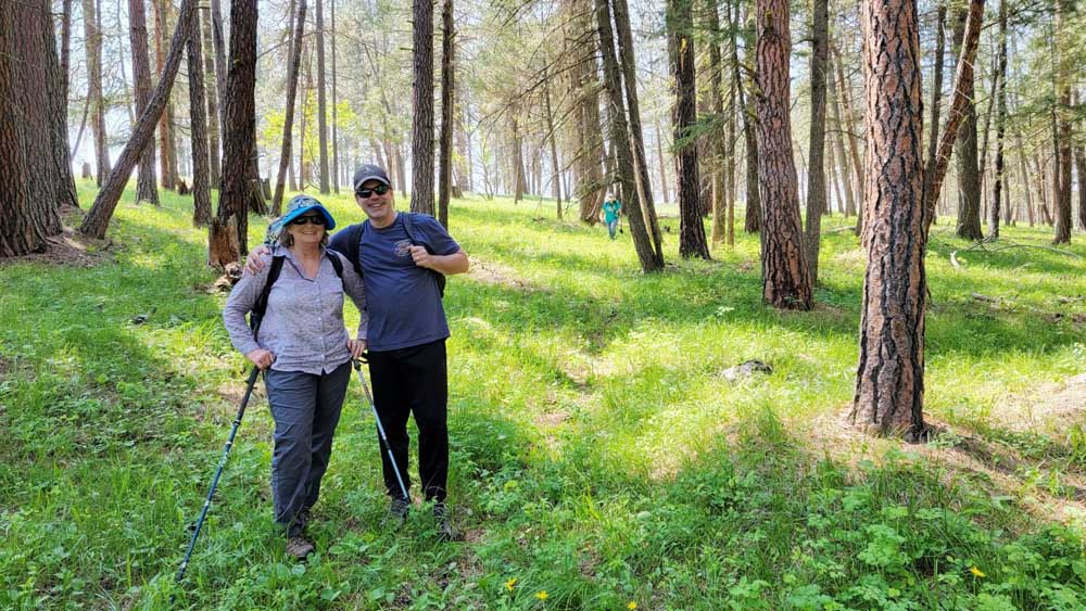
- Wagon rut field researchers Sherrill Beck and Mark Mulvihill are shown here walking the Oregon Trail in the area of Hilgard State Park. The Blue Mountains were by far the most treacherous part of the pioneers’ journey because those coming over in 1843 had to fell the trees first before they could cover any ground by wagon. Those who made the trip in five months were doing well.
PENDLETON — Since the first major migration to Oregon in 1843, Oregon Trail ruts have become the growing fascination of thousands of historians, authors, teachers, and students across the nation.
But none are more dedicated to protecting this legacy than the Oregon-California Trails Association, which will hold its National Historic Trails Conference July 21-25 at the Wildhorse Conference Center.
Trending
The OCTA organization is divided into chapters and the Northwest Chapter of OCTA is led by its president Susan Badger-Doyle. The chapter covers Oregon and Washington. A sub-set of four members from this chapter is currently conducting field research by walking the trail ruts, documenting what they see, taking photographs, and for the first-time using GPS tracking technology to map the trail with the greatest accuracy ever incorporated into a map of the Oregon Trail.
Among those researchers is Intermountain Education Service District Superintendent Mark Mulvihill of Pendleton, who for half the year spends weekends in the Blue Mountains from Ladd Canyon to Pendleton, researching the ruts with his colleagues Jenny Miller, Robin Baker and Bob Camp.
“I joined them about three years ago because I’ve always had an interest in history and the Oregon Trail, and especially the Blues,” Mulvihill said.
The scope of their research includes the Ladd Canyon summit area, Clover Valley, North Powder, all the way through the Grande Ronde Valley, over Hilgard and to Poker Jim Hill, which leads to the Cayuse on the Confederated Tribes of the Umatilla Indian Reservation.
“We use everything from pioneer diaries to the highway reports, the Hornbuckle to Jack Evans, who was a professor at Eastern Oregon University. We’re basically building on the work of everyone ahead of us with modern technology,” Mulvihill said.
To create the most accurate maps, Mulvihill said they have overlaid all the older maps and put them on their phones using Caltopo map software. With this tool in their hands as they hike, they can find the remnants of the trail in the Blue Mountains and map them.
Trending
The older maps were created without modern technology, so the researchers wondered how accurate the older maps are. They soon found out.
“When we actually got out there, we found there’s no way the Oregon Trail went through where they had it marked,” Mulvihill said.
Sometimes the trail was placed in three or four different spots according to these older maps.
“A lot of those cartographers never got out of their cars if they were even in that area with a car,” he said.
Other challenges they face finding the trail ruts were attributed to soil disturbances caused by livestock grazing, soil erosion, overgrowth of vegetation, land development for the interstate and years of cultivation and farming.
The search is further complicated by the construction of other early roads like toll roads, wagon roads and freight roads. That routes left ruts that crisscross each other, and the Oregon Trail through the Blue Mountains.
“This has become a multi-year field project exploring trail remnants and probable routes on the ground,” said Badger-Doyle, current Northwest Chapter president and a 39-year member of the OCTA. “The Blue Mountains project is indefinite and will continue until an accurate map and all documentation is compiled.”
Despite the confusion, the researchers are helped by remembering that the 1843 Oregon Trail pioneers always took the easiest way west, following earlier trails like game trails, Native American trails, fur trappers’ trails and early explorers’ paths. It was the best route then, and today’s Interstate 84 follows it closely.
“In our field research, we’re never very far from the interstate,” Mulvihill said.
He likened their search for Oregon Trail ruts to a treasure hunt, where the researchers use clues from pioneer diaries, including descriptions of the landscape using measurements in terms of chains (22 yards) and rods (5.5 yards). The trail can be elusive at times — evident for a stretch and then missing and then picking up again.
To Mulvihill the hunt for ruts is a test of scholarly analysis, piecing together diary clues and looking at the terrain from new perspectives until they finally find the ruts. With this methodology, they have been frequently rewarded.
“It’s a lot of fun really,” Mulvihill said.
The Mapping Master, Robin Baker
In his field exploration over the Blue Mountains, Mulvihill works with Robin Baker of Beaverton, who has deep ancestral roots in Northeast Oregon. He joined the Northwest Chapter of OCTA in 2015, and in 2021 he became the mapping chairperson for the chapter. He has been mapping the Oregon Trail for going on four years.
Baker said that their approach to research and field exploration is heavily dependent upon the General Land Office plat maps and especially the early surveyor’s notes, both available now on the Bureau of Land Management’s website.
“We also utilize GPS tracking and photo location to determine where we have explored and where our photos have been taken,” Baker said.
There were previous Oregon Trail researchers, such as Earl Bickmore of the Oregon State Highway Department in 1956-1958; the BLM’s Percy Brown, and the National Park Service’s Aubrey Haines in the early 1970s, as well as John W. Evans in the 1980s. Evans was an OCTA member and author of “Powerful Rockey: The Blue Mountains and the Oregon Trail, 1991.” They each made maps, but as trail researchers, they didn’t have the advantage of search engines, Google Earth, and archival records on the Internet, as Baker has today.
“They did not have easy access to General Land Office plat maps and surveyor’s notebooks, which were then only available in paper form; nor did they have the advantage of GPS to track where they had explored and where their rut discoveries were to a high degree of accuracy,” Baker said.
When Earl Bickmore of the highway department worked on the project, he wrote an interdepartmental correspondence dated Jan. 26, 1959, to Mr. P.M. Stephenson, assistant state highway engineer in Salem, stating, “The general route of the ‘trail’ was of common knowledge, but its exact location was our problem.”
Baker said that the engineers were tasked with mapping the Old Oregon Trail, from the Snake River to The Dalles, and their deadline was before the 1959 Oregon statehood Centennial. They weren’t allowed to work on the project during regular work hours, so, according to Bickmore, the project was carried on almost entirely on weekends and holidays for two years.
The highway department mapped the Oregon Trail west of Meacham and west of Emigrant Springs State Park, which was the toll road.
“Right there is a perfectly good set of ruts that go for about three miles from near Emigrant Springs State Park to Ross Road. That’s the toll road, and the later surveys bear that out,” Baker said.
Being in a bit of a hurry, though, and without the advantages of modern technology, the maps were “pretty good,” Baker said, but not as exact as GPS tracking technology and field research can make them.
That’s what Baker wants to achieve. Already, Baker and his associates have identified some mapping corrections to the previous maps of the Oregon Trail route.
Baker shares his maps with other OCTA members and would like to make them available to the interested public with Jenny Miller’s assistance.
Spreading awareness through education
Longtime Oregon Trail enthusiast Jenny Miller, of Pilot Rock, joined in 1998 and has been recently elected to the National OCTA Board of Directors for a three-year term.
“I’ve been on a lot of the trail from Independence, Missouri, to Champoeg State Park in the (Willamette) valley,” Miller said.
Now that she is on the board of directors, Miller’s focus will be on increasing public awareness of the Oregon Trail history and sites. As a former elementary school teacher, she’s interested in getting instruction materials and auto tour maps out to teachers.
“We have a board meeting in March and will start talking about putting materials online because it’s easier for educators to access this way,” Miller said.
Additionally, the National Park System now has driving guides for all the states traveled across by the Oregon and California Trails. Missouri, Kansas, Wyoming, Idaho, and Oregon were published in the past three months, so people could get those if they wanted to see the big picture of the Oregon Trail.
She is also focused on marking the trail over the Blue Mountains.
“Three summers ago, trail markers were placed along Foothill Road by the Schmutz farm southwest of La Grande and one on the side of Morgan Lake Road,” she said. “The last one we put in was at Corral Spring Oregon Trail Site. Most people don’t know about that one, but it’s beautiful.”
Miller enjoys showing people Oregon Trail ruts between Pendleton and Echo because it’s close to where she lives. She warmly invites people to attend the National OCTA Historic Conference at Wildhorse Casino in Pendleton in July.
“We would like people to come for part of it or for field trips to learn what they have in their own backyard,” she said.
To become a member of OCTA, visit the OCTA website or Facebook page. Also check the YouTube channel on their website every Tuesday and Friday to view the latest new video on the Oregon Trail.
“This has become a multi-year field project exploring trail remnants and probable routes on the ground. The Blue Mountains project is indefinite and will continue until an accurate map and all documentation is compiled.”
— Susan Badger-Doyle, president of the Oregon-California Trails Association Northwest Chapter
Conference
The Oregon-California Trails Association will hold its National Historic Trails Conference July 21-25 at the Wildhorse Conference Center in Mission.
For information, visit octa-trails.org.
Marketplace


Best of the Best of Bend 2025

-
eEdition

-

-