Central Oregon trail conditions: Find 13-inch kokanee at Paulina Lake, and a nice day out; Get out to Lookout Mountain for change of scenery
Published 10:30 am Friday, July 19, 2024
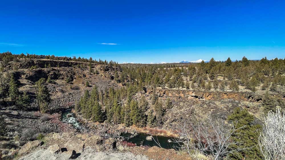
- The Deschutes River far below the Awbrey Reach section of the Deschutes River Trail as it bends near Archie Briggs Canyon.
Things are heating up again this weekend. After some days in the low 90s and high 80s, the high Saturday — and for the weekend — is 98 degrees Fahrenheit. Lows at night are in the 50s and 60s, while skies should be clear and sunny all weekend long.
In fact, the 10-day forecast has no sign of precipitation. Tuesday’s rain didn’t have much impact on nearby trails, so expect them to remain loose and sandy for weeks to come.
Check out bendtrails.org and the BendTrails Facebook group for more specific trail updates and be sure to provide updates if you happen upon some changing conditions. Below are some recommended spots for recreation this weekend.
Find 13-inch kokanee at Paulina Lake, and a nice day out
Anglers report productive rainbow trout fishing and excellent kokanee fishing with fish averaging 13 inches on Paulina Lake, according to the Oregon Department of Fish and Wildlife website. Anglers can also now keep five kokanee in addition to daily trout limit. If you want to look into the record books: in May of 1993, a 27-pound, 12-ounce brown trout was pulled out of the lake to set a Oregon state record, according to the U.S. Forest Service website. The state record kokanee, a 4-pound, 2-ounce fish captured in 1989, is also from Paulina Lake.
Along with record-breaking, the lake also makes for a great destination for a day out on the water. Whether in a paddleboard, kayak or small fishing boat, as motorized boats are allowed, the lake that sits over 6,000 feet above sea level offers terrific landscape views of Paulina Peak and the rest of the Newberry Caldera. The lake and its smaller twin, East Lake, and the rest of the collapsed caldera area were formed by volcanic activity more than 500,000 years ago. Both lakes rely on rain, snowmelt and hot springs for water as neither have an inlet stream.
Another point of interest is the twin waterfall on the caldera’s west wall. Paulina Creek has created a narrow gorge through the volcanic area as it drains Paulina Lake. There are also thermal vents and hot springs along the lake’s northeast edge. The lake is about 25 miles south of Bend (east of La Pine) and a nearly 50-minute drive.
Check out the department of fish and wildlife’s website for more fishing reports.
Get out to Lookout Mountain for change of scenery
If you’re getting sick of the sandy trails west of Bend, or just in need of a change of scenery, take a drive over to Ochocos and try out Lookout Mountain. Said to be one of the best downhill trails in Central Oregon, from the summit, the trail drops about 3,500 feet in 7 miles. It has varying terrain of rough, rocky and technical singletrack for the first few miles, then fast and flowy trail toward the bottom, with just a few short uphill punches. The trail was also cleared of downed trees and debris last month so it should be flowing smoothly.
Many riders will climb or shuttle Canyon Creek Road to the summit trailhead, but there is also an alternative climbing route along Independent Mine Trail. Make the most of a trip out east and summit both Round and Lookout mountains as part of a bigger loop. The best time to ride these trails are in late summer and early fall.
Hunters, hikers and horseback riders also use these trails. So keep an eye out and be prepared to the share the trail.
Note from last week: A reader let me know a useful tidbit I was unaware of, which is that the middle section of Flagline in the Swampy Lakes area is closed until Aug. 15 due to elk calving. The upper and lower sections are not affected, according to bendtrails.org, but riders should keep it in mind when in the area and trying to cut over to the Metolius-Windigo trail. Use Northfork until the middle of next month.
Early-morning, late-evening walk, run on Deschutes River Trail
Due to the heat wave over the past couple of weeks, I’ve taken to getting out on the Deschutes River Trail early in the morning or late in the evening to dodge the mid-afternoon highs. The gravel sections on the north and south ends of town, and various spin-off trails along the canals, such as the Central Oregon Historic Canal Trail, heading east from Brookswood Boulevard just south of Blakely Park, are my favorite.
On the north end, the Deschutes River Trail curves around the north side of Awbrey Butte through Awbrey Reach and along Archie Briggs Canyon. This section offers some rolling terrain and landscape views of the High Desert and Deschutes River in the canyon below. Also, there’s a great spot to dip in the river by the bridge at First Street Rapids Park as you make your way back toward downtown.
Possibly the most popular section of trail is on both sides of the river southwest of Riverbend and Farewell Bend parks. The winding and rolling gravel trail follows the river for a couple of miles before coming to bridge to take you back along the other side of the river. Don’t worry about getting too hot because there’s plenty of spots to take an impromptu dip in the river if you sense you might be overheating.
With the heat and possible smoke this weekend, these spots are convenient for a quick jaunt before or after work or to sneak in between family activities and responsibilities. They can be enjoyed as a run, walk or bike. If biking, be sure you picked a section of trail where bikes are allowed.
For a full list of conditions updated regularly, visit bendbulletin.com/explore/conditions.
How to float the Deschutes River in Bend this summer


Best of the Best of Bend 2025

-
eEdition

-

-
Go! eEdition