Ash, smoke descend after wildfires forced evacuation of Mt. Bachelor, other locations
Published 1:30 pm Monday, September 9, 2024
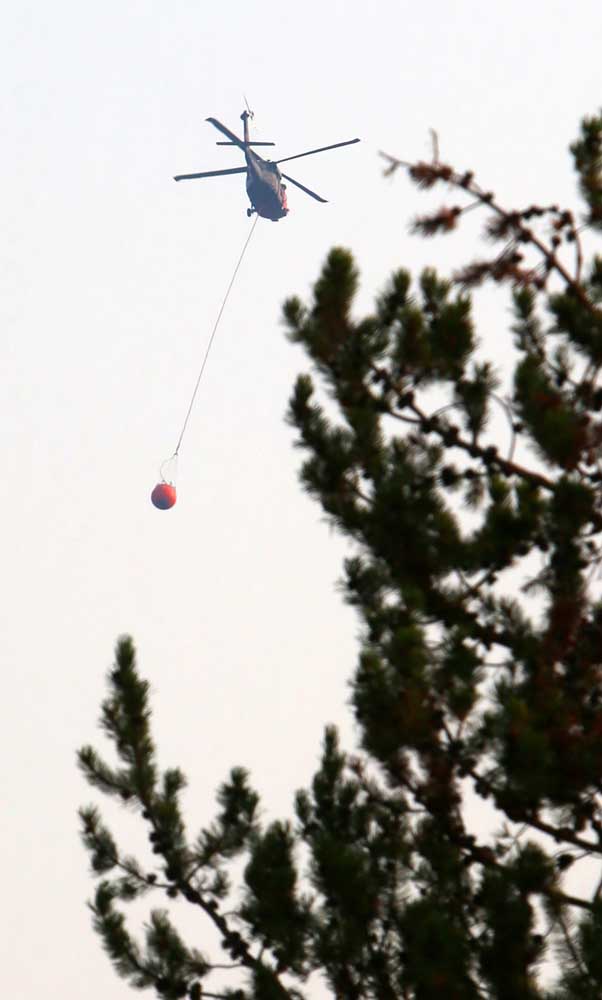
- A helicopter hauling a full bucket of water heads to a wildfire in Central Oregon on Sunday. Multiple fires burned throughout the region over the weekend.
Lightning strikes combined with hot and dry conditions spread multiple fires over the weekend on the Deschutes National Forest, burning thousands of acres of forestland and creating smoky conditions for communities across the region.
Wildfires impacting the area include the Flat Top Fire burning 10 miles north of Fort Rock, the Firestone Fire burning 21 miles north of Fort Rock, and the Bachelor Complex Fire burning 20 miles southwest of Bend.
Trending
The Oregon Department of Environmental Quality issued an air quality advisory for Deschutes and Crook counties, as well as southern Jefferson County. The advisory was expected to be in place until Wednesday afternoon.
Cascade Mountains fires
The Bachelor Complex Fire, which includes the 1,000-acre Little Lava Fire and the 80-acre Backside Fire, is burning in a roadless area west of Mount Bachelor. It has prompted Level 3-Go Now evacuation orders for areas east of Hosmer Lake and Little Lava Lake to Forest Road 45 (River Summit Road), the Deschutes County Sheriff’s office said in a statement.
The evacuation areas include popular recreation areas of Mount Bachelor, Sparks Lake, Devil’s Lake and Todd Creek Horse Camp. The Cascade Lakes Highway forms the northern boundary of the Level 3 evacuation order.
The Backside Fire shut down operations at Mt. Bachelor ski area on Sunday. The resort has a plethora of summer activities, including biking, hiking and zip-lining. Lauren Burke, a spokesperson for the resort, said operations are expected to resume Thursday, per its normal autumn schedule, which are Thursday to Sunday.
Other fires
Trending
Evacuation orders are also in place for areas around the 14,400-acre Flat Top and 6,700-acre Firestone fires, burning in southern Deschutes and northern Lake counties. Level 3-Go Now evacuation orders include Pine Mountain and areas south to the Lake County line. Impacted areas include forested areas southeast of the Newberry Crater National Monument.
Wildland firefighters were also busy over the weekend on the west side of the Cascades in the Willamette National Forest. One burn area has closed a 20-mile stretch of McKenzie Pass Highway, also known as state Highway 242, east of Belknap Springs. Fires in the area include the 3,397-acre Ore Fire, the 1,312-acre Pyramid Fire and the 621-acre Linton Fire.
These and other fires darkened skies over the Bend over the weekend and left fine particles of ash on cars and window sills. The air quality index in Bend was between 153 and 166 as of 11 a.m. on Monday. Both Redmond and La Pine had air-quality levels of 160 while the levels were lower in Sisters (140) and Prineville (75). The worst air quality in Oregon on Monday was registered in Burns, which had an air-quality level of 203.
Levels between 101 and 150 are considered unhealthy for sensitive groups while levels between 151 and 200 are considered unhealthy for all groups. Levels between 51 and 100 are moderate.
Jaimie Olle, a spokesperson for the Deschutes National Forest, said both Oregon and Washington are at a preparedness level 5, which makes the states eligible to receive national resources to support fires.
Favorable weather
The weather may also become favorable for firefighters.
Forecasts do not show any significant wind or strong heat wave that could worsen wildfire conditions, said Larry O’Neil, an associate professor at Oregon State University’s College of Earth, Ocean and Atmospheric Science.
“There are periods of cool weather and some rain in the forecast in Central and Eastern Oregon Wednesday night through Friday morning and possibly again early next week,” said O’Neil. “The rain amounts will be relatively light … enough to help slow wildfires but not end them.”
O’Neil adds that thunderstorm activity is something to watch for, but cooler nights could help mitigate the spread of fires.
“The arrival of more fall-like weather can help moderate fire activity, although it will not quite be enough to end fire season,” said O’Neil. “There may be a brief period of warmer and drier weather toward the end of the month, although it should not be a significant worry for large fire growth.”
Other large fires burning in the Central Oregon region and their statuses Monday include:
• Rail Ridge Fire located 14 miles south of Dayville had burned 146,601 acres and was 7% contained. It is burning on lands managed by the Ochocho National Forest and the Bureau of Land Management.
• Copperfield Fire located 6 miles southeast of Chiloquin had burned 3,822 acres and was 77% contained. This fire has burned eight residences and 22 other buildings.
• Wiley Flat Fire located 22 miles northeast of Brothers had burned 26,873 acres and was 13% contained
• Red Fire located 16 miles northwest of Crescent had burned 1,554 acres in the Diamond Peak Wilderness and was zero percent contained.
Marketplace


Best of the Best of Bend 2025

-
eEdition

-

-