Guest column: Gravel riding to Haystack and back
Published 9:00 am Thursday, December 5, 2024

- Junipers with Smith Rock, at right, behind them.
Keep The Haystack in mind for a sunny, mild winter day.
This 20-mile gravel bike ride, described in detail on the Dirty Freehub website, travels from Peter Skene Ogden State Scenic Viewpoint, up to Haystack Reservoir, and down through the Crooked River National Grasslands.
Trending
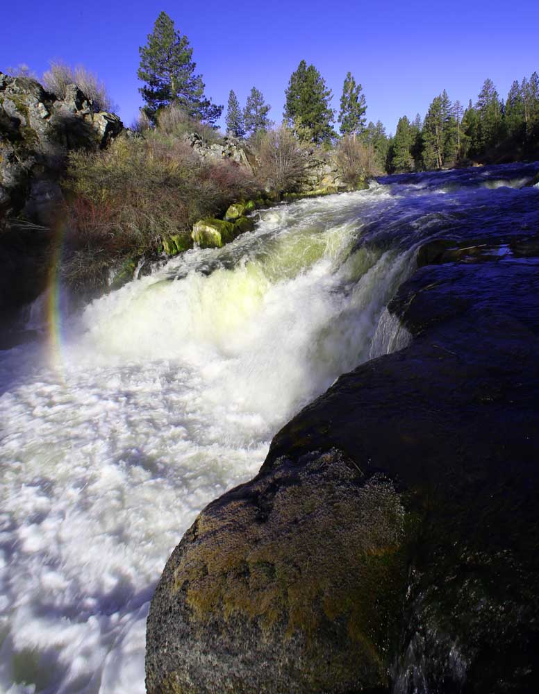
One of the ride’s grandest views comes right at the start (and end), as you stare down a 300-foot-deep, 450-foot-wide basalt canyon at the Crooked River, a tributary of the north-coursing Deschutes River.
Immediately after that dramatic view, you face the ride’s crux: crossing Highway 97. As you stand on the shoulder, waiting for your window of opportunity to cross four lanes of north and south bound traffic, imagine the deer and other wildlife who would like to cross through this area to access different habitats if they could.
Once across, you’ll reach a gate. Lift your bike over, then climb over yourself and drop down to the other side to catch the terminus of the SW Culver Highway. (Not interested in highway crossing and gate hopping? Pick up the route on the east side of 97 instead; a wide stretch of gravel at the SW Norris Lane and SW Culver Highway intersection would be a serviceable parking spot).
This quiet stretch of road offers wide open views of snowcapped Cascade volcanoes to the west and the craggy hills of the Crooked River National Grasslands to the east. Under blue skies, it’s textbook bucolic.
In your foreground, you’ll see irrigated farm fields. The farms in North Unit Irrigation District are both the most water-efficient and the most profitable farm operations in the region. They provide a useful model that other irrigation districts in the region should look to if we want to conserve water and grow local crops.
As you get into the rhythm of the road, you could easily ride past the right-hand turn onto the unnamed gravel road/trail suggested on Dirty Freehub’s route map. Should you (also) find yourself reaching Highway 97, backtrack a quick half mile to SW King Lane and take that fairly smooth gravel road west to Haystack Reservoir.
Trending
At the T intersection with SW Haystack Drive, turn left. The Dirty Freehub Haystack route goes right at this intersection, but you’re going to head left first for a closer look at Haystack Reservoir. You’ll soon pass by Haystack Reservoir Campground West and, less than a quarter mile more, turn left to reach the North Fishing Pier Day Use Area.
Managed by the Crook County Parks and Recreation Department, Haystack Reservoir covers just over 200 acres. The area provides scenic views of Mount Jefferson and the Three Sisters, fishing year-round, and camping April through October.
Near the fishing pier, you’ll find a picnic table set on chunky lichen-crusted basalt, flanked by junipers. On this trip, fog swirled just above the water, adding an air of mystery, but limiting my view. Luckily, I’d been here a few weeks earlier on a Central Oregon LandWatch staff field trip, and could rely on memory to fill in the expanse of water past the current cloud bank.
Irrigation efficiency measures
If you’re interested in water conservation and irrigation efficiency measures, continue north on Southwest Haystack Drive a half mile to reach the South Unit Main Canal, just shy of the intersection with Southwest Jericho Lane, and check out the large concrete intake structure designed to remove debris from the canal system.
As the most junior irrigation district in the Deschutes Basin, North Unit Irrigation District is last in line to receive water. Some years it only receives a fraction of the water needed to grow a crop. By necessity, North Unit is the most efficient irrigation district in the Basin and its approach to managing water provides a model that LandWatch hopes other irrigation districts in the Deschutes Basin will follow.
From Haystack Reservoir, I’d intended to continue on the suggested lollipop loop, traveling on gravel roads through the grasslands.
Storm rolling in
However, the wisps of fog were now a thick blanket. Visibility was not stellar. Air temperature had dropped considerably. And the mood? Downright gloomy. This was a distinct contrast from the blue skies I had expected to last through the afternoon. A storm was rolling in.
Consulting my map, I could see that the route was fairly straightforward but had some potential to be confusing in the Henderson OHV Staging Area. As I weighed the risk of losing time to getting turned around against the potential adventure and beauty to be had if the fog lifted, the sounds of gunshots cracked in that direction. Back at the T, I turned right to make this an out-and-back trip and cruised back via the paved road.
Bend’s most missed restaurants.
When I reached SW Park Lane, the road I would have come out on if I’d ridden this as the loop, the sky above was blue. Rather than head to my car, I turned left to recoup some of what I’d missed out on. Riding up to and back down from the Corrals Trailhead gave me a small, fun taste of the gravel section and, from Park Lane, I enjoyed the cool, not-as-often-seen view of Smith Rock’s north side.
When you attempt this ride, be sure to go on a Wednesday through Sunday and be back to your car before 4 p.m. That way you can pair your bike ride with a visit to Maragas Winery to enjoy a glass of wine made from locally grown grapes and a delightful array of snacks in a space that is both cavernous and cozy.
From Maragas, I drove back to Haystack Reservoir to check out the stretch I’d missed, but couldn’t see anything at all. A freezing fog advisory had kicked in. I felt good about my earlier decision — and grateful for the reminder that, in winter especially, outdoor plans can and should be adjusted.
Marketplace

Best of the Best of Bend 2025

-
eEdition

-

-