Hurry! Two more weekends to hike Dry River Canyon
Published 1:00 pm Wednesday, January 15, 2025
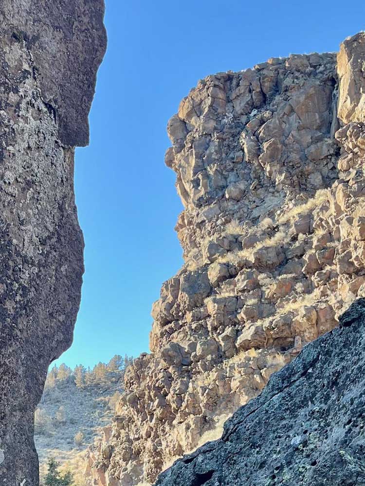
- Blue sky peeks through the rugged walls of Dry River Canyon.
Dry River Canyon southeast of Bend isn’t going away any time soon, but human access to it will be when the annual closure to protect nesting prairie falcons and golden eagles goes into effect February through August.
Located just past The Badlands below U.S. Highway 20, Dry River Canyon is the deep, stunningly rock-lined canyon formed by a river that once drained from an ancient lake. Since it’s open only through the end of January, you have about about two weeks to get there — which means get there while the getting is good.
And as my wife and I learned firsthand last weekend, the getting is particularly ripe right now. We’ve been to Dry River Canyon many times over the two-plus decades we’ve lived in Bend. Given its five-month accessibility, and the winnowing of other hiking options until spring, we’ve often ended up there in the winter. Usually, due to the frosty, even icy conditions we have gone part of the way on the 3.2-mile trail, then turned around short of the opposite end after having had enough of slippery ice and packed snow.
According to oregonhikers.org, lots of people make it about 2.3 miles in, until they encounter a boulder field, making it 4.6 miles round trip. But there is also the option of getting around the boulders, making it 3.2 miles if you do the entirety of it. We began climbing them, then realized there is a trail that skirts above it slightly up the west side of the canyon above, then drops for the last half mile to where the trail begins to spit you out near Highway 20.
We’d never previously made it even as far as the boulder field for reasons already mentioned — until Saturday, that is. We started from the northern trailhead, heading south-southeast through the canyon. The recent spate of dry weather, which is supposed to continue at least into next week, meant mostly firm trail tread, which led us to just keep on going.
And for the first time, we made it to the southern end of the trail at the bottom of the canyon, which parallels Highway 20, though far below the steep grade that leads up to Horse Ridge Summit, and emerged just past Horse Ridge Summit, across from the Millican OHV. (Interesting tidbit for AllTrails users: The app had suggested we park and start the hike at this far end, which seemed bizarre to me having hiked here so many times before and never even having made it to that end before. Plus, if I’m looking at satellite images correctly, you’d have to sprint across Highway 20 from the Evens Well OHV Trailhead.)
Along with the stunning basalt walls above the trail and water-scoured boulders sitting there in its bottom, there are at least two other towering reminders of the canyon’s damper past: two giant ponderosas, one dead but standing, the other seemingly hanging on for dear life, near the boulder field. Both look out of place this far east, surrounded by junipers, which dominate the area in and around the canyon.
Sturdy shoes and mindful layering are advisable on this hike. Temperatures can shift up and down during a hike through sun and shade in winding Dry River Canyon. Our early afternoon hike back to our vehicle was shadier than expected, and a wind out of the north seemed to pick up as well, unless we’d unknowingly had it at our backs the initial direction of travel.
Getting there: From Bend, head east 17 miles on U.S. Highway 20. At the bottom of the grade, just past milepost 17, turn left and then immediately right into the gravel area, and continue toward the sign leading to Dry River Canyon Trailhead. Or park there and begin hoofing it, because for the next mile, a high-clearance vehicle is the best way to get to the main trailhead. We saw a minivan navigate it, though I couldn’t attest as to whether or not they scraped their vehicle’s undercarriage.


Best of the Best of Bend 2025

-
eEdition

-

-
Go! eEdition