Guest column: 5 off-the-beaten path places to snowshoe near Central Oregon
Published 6:30 am Thursday, January 23, 2025
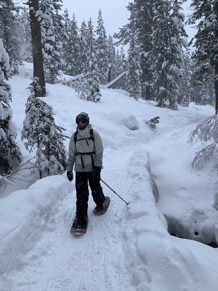
- Hiking at Tumalo Creek Trail. Snowshoers can make a loop out of the 6-mile jaunt by taking Tumalo Creek Road (closed to traffic in winter) and returning along the creek trail, on the south side of Tumalo Creek.
Many experienced snowshoers in Central Oregon are likely familiar with the well-maintained network of trails along the Cascade Lakes Highway west of Bend. Several Sno-Parks such as Virginia Meissner, Swampy Lakes, Vista Butte and Dutchman Flat provide parking and easy access to these trails.
However, because they are close to Bend and popular with other winter recreational users like cross-country skiers, backcountry skiers and snowmobilers, these sno-parks and trails can quickly become overcrowded on busy weekends.
Trending
If you want to ditch the crowds, walk through magical snowy landscapes, and don’t mind driving a bit farther, here are five other options for snowshoeing within 90 minutes of Bend.
Paulina Creek
Nestled in Newberry National Volcanic Monument, Paulina Falls is a captivating winter destination for snowshoers and skiers. The Paulina Creek Falls Trail takes you through a serene forest, offering glimpses of the icy Paulina Creek and leading to the breathtaking viewpoint of the Paulina Falls.
Follow the trail a little farther past the falls to reach the outlet of Paulina Lake and enjoy the scenic splendor of a volcanic caldera turned winter wonderland. On weekends in the winter, the Paulina Lake Lodge restaurant is open to thaw you out with a hot drink or warm meal.
Distance: About 7 miles roundtrip to Paulina Lake and back
How to get there (40 minutes from Bend): From Bend, head south on U.S. Highway 97 for about 24 miles. Turn left onto Paulina Lake Road towards Newberry Crater. Continue for about 10 miles until you reach the 10-mile Sno-Park on the left side of the road.
Trending
Recreation passes/fees: Sno-park pass
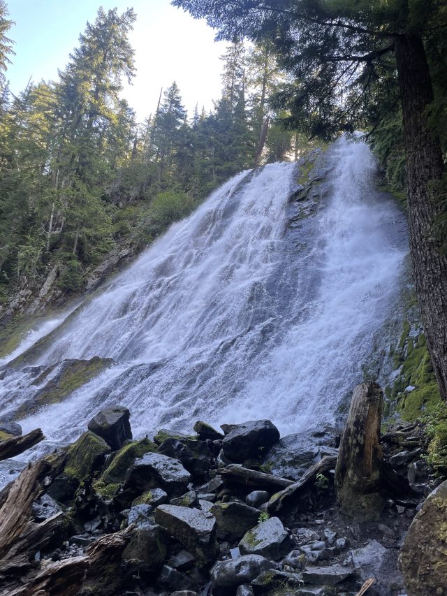
Salt Creek Falls
Situated just off State Highway 58 in the Willamette National Forest, Oregon’s second-highest waterfall — Salt Creek Falls — transforms into a mesmerizing icy spectacle during the winter months. The short Salt Creek Falls Trail offers stunning views of the 286-foot waterfall and includes viewing areas at the top and bottom of the falls.
For a longer loop hike, follow Salt Creek upstream until you reach the Diamond Creek Falls Trail, which takes snowshoers through a beautiful old-growth forest and provides viewpoints of Diamond Creek Falls and Salt Creek. Make sure to follow the trail markers (they look like blue diamonds), as route-finding can be more difficult when the trail is covered in snow.
Distance: About 1-mile roundtrip to Salt Creek Falls; 4.5 miles for the Diamond Creek Falls loop
How to get there (90 minutes from Bend): From Bend, head south on U.S. Highway 97 for about 45 miles. In Crescent, turn right onto the Crescent Cutoff Road. In 12 miles, turn right onto Highway 58. In about 16 miles, turn left toward Salt Creek Falls. Then turn left to cross a bridge and continue to the parking area at Salt Creek Summit Sno-Park, where you’ll find a vault toilet.
Recreation passes/fees: Sno-Park pass
Hackleman Creek Old Growth Grove
Located right off Highway 20 and accessible year-round, the Hackleman Old Growth Trail takes hikers through an enchanting old-growth forest of ancient Douglas fir and western red cedar in the Willamette National Forest.
Use extra caution in route-finding as the trail and trail markers may be completely hidden under the snow. However, even while taking care to follow the trail, don’t forget to look at the expansive canopy of the forest above.
These giants provide a glimpse of the once widespread ancient forests that covered this part of Oregon. A century of unsustainable logging practices decimated these forests across the state, but the remaining patches are hotspots for biodiversity and are among the most carbon-dense forests in the world. When left standing, these forests accumulate and store carbon from the atmosphere for many centuries. Even when trees die of natural causes like fire and wind, this carbon is recycled back into the ecosystem and stored in the rich layers of living soil, nourishing the next generation of trees.
Despite its small size, the Hackleman Creek drainage is also home to an impressive array of biological diversity, including the Hackleman trout — a subspecies of cutthroat trout that only survives in this creek.
Distance: 1 mile
How to get there (70 minutes from Bend): From Bend, take US-20 west towards Sweet Home for about 55 miles. Park just off the highway at the Hackleman Old Growth Grove Trailhead, about 2.5 miles east of Tombstone Pass on Highway 20.
Recreation passes/fees: none
Walton Lake
Starting from Walton Sno-Park, a 3.5-mile loop winds through an old-growth ponderosa pine forest next to Ochoco Creek and Walton Lake in the Ochocos. From the parking lot, head north and cross the road (Forest Service Road 22) that you came in on. At Trail Junction A, stay left and continue for another ¼-mile until you reach Trail Junction C. Here, you can either make a clockwise loop by turning left toward the lake or taking the counterclockwise loop by staying to the right and continuing towards Trail Junction B, where you will turn left to continue on.
Since the trail and trail markers can be difficult to follow here, it is recommended to carry a trail map and GPS device to ensure you are following the correct path. The FS 22 Road may also be unplowed, so if there has been recent snowfall, make sure you have a properly equipped vehicle.
Distance: 3.5 miles
How to get there (90 minutes from Bend): From Prineville, take U.S. Highway 26 east for about 15 miles. Turn right at the junction to Walton Lake and Big Summit Prairie. Continue for about 8 miles and turn left onto Forest Service Road 22, towards Walton Lake. In about 7.5 miles, Walton Lake Sno-Park will be on your right.
Recreation passes/fees: Sno-Park pass
Tumalo Creek and Falls
Located just outside of Bend, Tumalo Falls is one of central Oregon’s most visited destinations in the summer. In the winter, the trail from Skyliner Sno-Park provides a perfect snowshoeing experience through a snow-laden forest alongside Tumalo Creek, with the reward of witnessing the majestic 97-foot waterfall framed by ice and snow.
To reach the falls, follow the Tumalo Creek Road (closed to vehicles in the winter) west for about 3 miles. Head back along the road for a 6-mile out-and-back hike. Alternatively, for a more interesting (and challenging) loop hike, hike back along the Tumalo Creek Trail on the South side of the creek.
Distance: 6 miles roundtrip
How to get there (15 minutes from Bend): From Bend, travel west on Skyliners Road for about 10 miles until you reach Skyliner Sno-Park.
Recreation passes/fees: none
Speak up for public lands
All of these destinations are located on federal public lands, allowing the general public to enjoy them year-round and have a say in how they are managed. There are current opportunities to speak up for these places and better protect them so future generations can continue to enjoy them.
Tumalo Creek, Paulina Creek, Hackleman Creek, Salt Creek, and Ochoco Creek are among the many Oregon streams that are included in Senator Ron Wyden’s River Democracy Act. In addition to being home to scenic waterfalls and dazzling old-growth forests, these watersheds also provide critical fish and wildlife habitat, other outdoor recreation opportunities and clean drinking water to downstream communities. The Tumalo Creek watershed supplies clean drinking water to over 100,000 people in Bend. If passed through Congress, the River Democracy Act would safeguard these watersheds and the important values they provide.
More Information
Interested in learning more about snowshoeing in Central Oregon?
Join Oregon Wild at Worthy Brewing on Wednesday, Jan. 29, to learn more about how to snowshoe, what to bring, and where to go.
Marketplace

Enter the $5,000 Sweepstakes

-
eEdition

-

-