Guest column: The implications of state fire maps for homeowners
Published 9:00 pm Monday, February 17, 2025

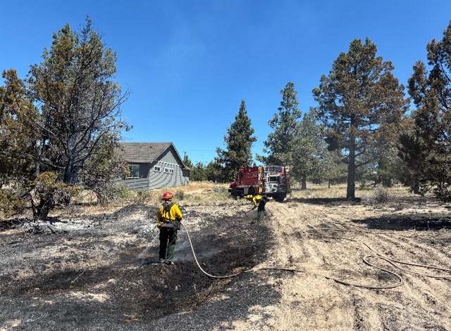
- Kevin Moriarty, Deschutes County Forester, on a fuels reduction project adjacent to a residential development off of McGrath Road, showing a trimmed tree in the foreground and an untreated area in the background.
On Jan. 7, the Oregon Department of Forestry (ODF) issued wildfire hazard maps covering the entire state. These maps, divide the state into three wildfire hazard classes, low, moderate, and high. An astounding 90% of Oregon is designated as moderate or high risk for wildfires. Property owners with a high designation should have already received notice from ODF.
These designations have significant implications for property owners. First, properties that have a high hazard designation and are in the wildland-urban interface area (those areas with urban services near most open space land) will be required to meet enhanced defensible space standards and home hardening codes. While seemingly innocuous, the defensible space standards are likely to conflict with local tree codes and habitat management requirements. These conflicts could cause serious challenges, such as when property owners are forced to comply with both local and state requirements and cannot. The home hardening codes present challenges as well. A recent survey of critical building materials shows a staggering 10 times price tag for certain items such as windows! These differences in pricing will dramatically increase home construction (and reconstruction) costs at a time when the state is grappling with a seemingly insurmountable housing crisis.
Trending
In addition to the immediate implications of a high designation, the long-term designation risks could prove far more challenging. The state or local governments could further erode property owners’ rights and prohibit the construction of new homes in certain areas. Senate Bill 79, which was introduced only 10 days after the maps were released, would prohibit home construction in areas with a high designation. It is reasonable to expect that anti-housing counties and cities will copy and paste Senate Bill 79 at the local level if a statewide ban fails.
Most challenging, however, are the implications for insurance costs. While state law prohibits the use of the ODF maps for insurance underwriting insurance proposes, this prohibition only provides a false sense of security. In all likelihood, insurance companies will study the ODF maps, develop similar maps of their own, and use those “new” maps to justify increasing rates or dropping coverage altogether. Wildfire risk underwriting is extremely important to the insurance industry and ODF maps — absent meaningful modification — will likely lead to dramatically increased rates statewide, even in areas where the wildfire risks are low. Additionally, as we have seen over the past several years, underwriting exercises related to wildfire risk has caused insurance companies to drop homeowner policies altogether.
Property owners have the right to challenge their designations and seek amendments to the ODF maps. The Office of Administrative Hearings will review challenges to the maps both in-person and virtually over the coming months.
However, the shot-clock for filing an appeal runs through March 10, and any well-positioned challenge will require site-specific analysis that could take weeks to complete. Property owners are advised to check the ODF maps and consider the implications that these maps have.
Trending
Marketplace


Best of the Best of Bend 2025

-
eEdition

-

-