For lava flows, singletrack and mountain views, try Black Rock Trail
Published 2:37 pm Thursday, April 10, 2025

Whether it’s the weekend or you have a window for an evening hike — an option for many of us between spring and fall equinoxes — a portion of Black Rock Trail makes for a terrific destination, whether you’re looking to do a quick out and back or all 4 miles.
I say this for a few reasons, but the Black Rock area seems to have many of the amenities Central Oregon is known for concentrated into one beautiful setting.
Singletrack? Yep, in fact, Black Rock is one of the oldest mountain bike trails in Central Oregon. There’s 4.1 miles of it, fairly easy with some technical sections. I usually opt to hike here, where Black Rock slices through a forest dotted with ponderosa pines to one side, and to the other, a sprawling, 6,000-acre lava flow, formed by, yes, lava that once gushed from nearby Lava Butte. The flow was enough to alter the course of the Deschutes River, and resulted in terrain so otherworldly that Apollo astronauts once trained here for moon missions.
Sun-Lava Paved Path
If a smoother path is more your thing, there’s even a nearby paved path, the 5.5-mile Sun-Lava Paved Path, paralleling Black Rock. Or split the difference. An out-and-back from the visitor center travels generally downhill, and Sun-Lava Paved Path makes that uphill hike back to your vehicle that much easier. It also makes a fine substitute for avoiding muddy conditions and doing damage to the trail.
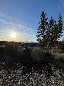
The sun prepares to set on a stunning Friday evening over the lava fields off of Black Rock Trail. (David Jasper/The Bulletin)
Travel the length of the trail and you’ll reach the mighty Deschutes River about a half-mile above Benham Falls for still more epic beauty. There’s more parking at Benham East Day Use at the west end of Black Rock Trail, and from that end, you could continue on upstream toward Sunriver or cross the footbridge to connect to Benham Falls and the Deschutes River Trail and continue to run, hike or ride downstream all the way back to Bend if it’s your fancy.
The most-used Black Rock trailhead, unless one is connecting from the Deschutes River Trail or Sunriver, is just off of Highway 97 at Lava Lands Visitor Center (58201 S. Highway 97), which according to Deschutes National Forest is projected to open May 9 this year.
Don’t let the location fool you. Black Rock Trail may begin amid the relative hustle and bustle of the center’s parking lot, but just a short distance down the trail and you’re soon away from it all, gazing up at the towering heights of ponderosa pines and surrounded by beautiful red-limbed manzanitas.
When you reach certain points, it offers unparalleled views of the area’s Cascades peaks including Mount Bachelor, Broken Top and South Sister.
When we go to Black Rock, it’s usually after hours or when Lava Lands Visitor Center, we park at the end of the lot nearest Sun-Lava Paved Path, wedged in forest between Forest Road 9702 the singletrack of Black Rock. Walk a short ways on the paved path and you’ll see Black Rock Trail off to your right.
Last Friday evening, my wife and I took an after-dinner hike here, hiking Black Rock Trail approximately 1.5 miles to where an old forest road traverses a portion of the lava field, connecting to an island of pines atop the lava rock, a perfect vantage point for gazing back at Lava Butte or across the fields toward Mount Bachelor and its neighboring peaks. Because we hadn’t planned on or equipped ourselves for a nighttime hike, we took the more direct Sun-Lava path back to our vehicle well before dark.

Mountains peek through the forest as seen from Sun-Lava Paved Path near Lava Lands Visitor Center. (David Jasper/The Bulletin)
For those looking for other hiking options, the visitor center also hosts Trail of Molten Land, which offers unrivaled views of the lava fields here, as well as Trail of the Whispering Pines. If you’re feeling particularly hardy, you can also hike to the top of Lava Butte. Those those willing and able to hoof it up the steep Forest Road 100, which corkscrews to the top of the butte, are treated to stunning views of the Cascades to the west, Paulina Peak to the southeast (also part of Newberry National Volcanic Monument) as well as Luna, Kelsey and other buttes to the east. During the summer season, there’s a shuttle to the top, which means now is a great time to make the hike, about 3.5 miles round trip from the visitor center.
But once you’ve been to the top of Lava Butte, there’s something to be said for seeing the butte from down below, so don’t sleep on Black Rock. A $5 day pass or valid recreation pass is required if parking at the visitor center.
Getting there: From Bend, drive south on U.S. Highway 97 to the Crawford Road entrance and proceed to the southwest of the visitor center, where parking is available even when the center is closed.


Best of the Best of Bend 2025

-
eEdition

-

-