Flowers and waterfalls in abundance on Salt Creek Falls hike
Published 1:00 pm Thursday, July 24, 2025
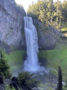
- The breathtaking cascades of Diamond Creek Falls. (Kelly Cleman)
Sometimes a place I’ve briefly visited stays in mind as an ideal location to revisit when hiking season begins. The Salt Creek Falls area was in that category as I had been there a few years ago in winter and the falls were incredible. Consulting a map afterward, I devised an 8-mile, 1,600 feet of elevation gain round-trip hike that included not only Salt Creek Falls but, by including a couple of connecting trails, added two more falls plus a visit up to Vivian Lake in the Diamond Peak Wilderness. I also wanted to view the rhododendron bloom happening in mid-to-late June. Falls and flowers, what a great combination!
Fourth of July dawned rainy and cloudy in Bend, so my out-of-town friend and I decided that this itinerary would be perfect regardless of weather. But as we drove south, the clouds started clearing and we were greeted by sunny skies as we entered the Salt Creek Falls sparsely populated parking lot, a few miles west of Willamette Pass along Highway 58.
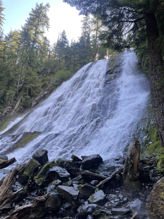
A lower view of Salt Creek Falls, the second tallest waterfall in Oregon. (Kelly Cleman)
Starting at the top
Salt Creek Falls is an impressive 286 feet high and is the second-tallest falls in the state behind 620-foot Multnomah Falls in the Columbia River Gorge. A platform overlooking the top of the falls is a short walk from the parking lot kiosk. From there, we walked .3 miles and 209 steep feet of loss down to another viewpoint closer to the base of the falls. Both views were excellent, providing different camera angles of the thundering, free-falling water. This area was pretty busy later in the day, so we were glad we went there first.
Trending
Walking back up to the top platform, we headed on the paved trail upstream along Salt Creek, crossing the creek on a wooden bridge. From there we followed a trail sign about 200 feet through forest to the well-marked junction for Trail 3598 to begin the 3-mile loop trail.
Watch your step
Heading north on the 1.8-mile right-hand trail, we quickly passed a short side-trail to small Many Bear Lake, which we decided to skip, and climbed up to the lip of the canyon above Salt Creek. This and other viewpoints along the way were quite exposed, so we watched our footing and didn’t get too close to the edge. The trail continued rolling up and down, passing several overgrown viewpoints along the way as well as numerous rhododendron plants in bloom.
The trail steepened as it transitioned from Salt Creek to smaller Diamond Creek and we labored up to a signed right-hand trail heading steeply down to Diamond Creek Falls. This was well worth the short detour as we walked right up to the base of the 100-foot falls, bathing in its misty, crashing splendor.
Diamond Creek Falls
Back on the main trail, we passed a viewpoint looking down on Diamond Creek Falls, and arrived at the unsigned junction for the 1.2 mile trail heading back left to the beginning of the loop. Foregoing this option, we continued on to the Vivian Lake Trail. We quickly emerged on to a dirt road next to a small parking area for adventurous drivers willing to navigate unsigned dirt roads for an easy walk to Diamond Creek Falls from the Salt Creek Sno-Park. We followed the road right, crossing over Diamond Creek on a concrete bridge. The trail resumed on the left immediately after the bridge.
We travelled briefly through a forested section before climbing up to a railroad track crossing. Crossing quickly, we found the trail as it resumed behind overgrown bushes to the left of the obvious road.
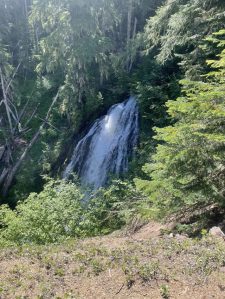
Fall Creek Falls (Kelly Cleman)
Passing through a short, brushy section, we entered the Diamond Peak Wilderness at a trail-side kiosk. We stopped here briefly to apply insect repellent as we were dive-bombed by mosquitoes. Hustling on, we navigated a few downed trees blocking the trail. The pink rhododendron blooms and giant stalks of bear grass were profuse along this section. The trail sidled closer to Fall Creek, tilting sharply up for about a mile until we came to an excellent viewpoint of 20-foot Fall Creek Falls.
Trending
From the viewpoint, the grade eased in the final mile before leveling out in the Vivian Lake basin. A sign nailed to a tree on the left directed us rightward onto a spur trail for the lake. We skirted around the left of the large lake on a user’s trail still soggy in places from recent snow melt. The trail became faint, but we followed a fairly obvious route to a large campsite perched right at the edge of the lake. A mild breeze kept the mosquitoes at bay as we took pictures and marveled at the lake’s inviting water perfect for easy wading and swimming.
Lakeside lunch
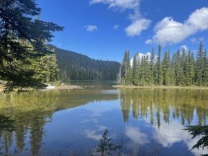
Trees and clouds reflect in the still waters of Vivian Lake. (Kelly Cleman)
After lunch, we explored but couldn’t identify a route to continue around the lake without bushwhacking. Looking at the shoreline across the lake, it didn’t look like there were any other campsites as large as the one we found, so I’m sure that it would get occupied quickly on a nice summer weekend. Backpackers can continue up the trail a short distance to smaller Notch Lake or head farther beyond for longer adventures.
We finished our lunch break and headed back down the trail, stopping only to take a few more flower pictures. We returned to the unsigned trail junction with Trail 3598 and veered onto the right-hand trail to complete the loop, reaching our original junction after 1.2 miles. Retracing our steps back to the bridge crossing of Salt Creek, we returned to the now-busy parking lot and our car.
If You Go
Go in the spring for flowers and when the waterfalls are running at their peak. Snow can linger in the area until mid-June, and once it melts the mosquitoes move in so bring bug spray or keep yourself covered. The trail is mostly shady, so trips later in the summer can be enjoyable if you want to avoid the bugs.
Directions to the trail can be found by using the mapping application on your phone to find Salt Creek Falls. The road to parking is paved and there is a toilet if you take a slight left detour on the access road to Salt Creek Sno-Park.
More detailed hiking instructions can be found in William L Sullivan’s “100 Hikes in Central Oregon Cascades.” Use a good paper map such as Adventure Map’s Oakridge, Oregon Trail map to help you navigate the junctions. You can also download an electronic version to your phone on the Avenza app or use mapping apps such as All Trails, ONX or Gaia.
After your hike, enjoy a stop for a snack a few miles back up the highway at Willamette Pass at either the restaurant or grocery store located there.
Marketplace


-
eEdition

-

-