Guest column: Survival and renewal on the Jefferson Lake Trail
Published 3:05 pm Thursday, May 22, 2025

- Mount Jefferson seen peeking above the forest beyond the lava flow. (Holly Scott)
In 2003, the B&B Fire incinerated thousands of acres of forest in the Mt. Jefferson Wilderness. One of the hardest-hit trails in the area was the Jefferson Lake Trail. After the fire, the trail was littered with a lot of blowdown and Ceanothus (aka “snowbrush”) grew rapidly, turning several miles of the trail into a nearly impassable jungle. To preserve resources, the Forest Service considered decommissioning the trail.
Then in 2015, Central Oregon couple Mark and Holly Scott adopted the trail. With the blessing of the Forest Service and the help of many volunteers, they began the laborious work of cutting out the fallen trees and lopping the overgrown snowbrush. Then in 2020, the Lionshead Fire torched the area around Jefferson Lake. Undaunted, volunteers resurrected this portion of the trail as well. Today, the almost 9-mile trail is clear up to the intersection with the Cabot Lake Trail at Patsy Lake. The side trail to Jefferson Lake is open to the outlet creek from the lake, though the lake area is heavily burned.
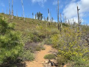
A look at the hillside burned by the B&B Fire above the trail. (Kelly Cleman)
I was introduced to the Jefferson Lake Trail a few years ago when I volunteered with a Save our East Cascade Trails (SECT) trail crew. SECT was founded to officially oversee maintenance on this trail as well as a couple of other trails in the Mt. Jefferson Wilderness. I’ve gone out on several work crews devoted to lopping snowbrush and removing invasive plants. I enjoy this trail for its solitude, wide-open vistas, and the pleasure of watching the wilderness slowly resurrect itself from the ashes of a destructive fire.
Trending
While avid day-hikers and backpackers will enjoy tackling the length of this trail, casual hikers can pick one of the following options: 2 miles, 4 miles, or 8 miles roundtrip.
Spring blooms
The trail begins in unburned, old-growth forest. Crossing on a bridge over Candle Creek, the trail passes immediately into the Jefferson Wilderness and between two halves of a giant tree that blew down in a storm several years ago. Because of wilderness prohibitions on mechanized equipment, the trail crew had to saw out a chunk of this tree using only crosscut saws — an impressive feat.
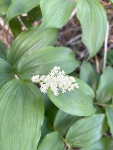
Feathery False Lilly of the Valley found in the old-growth section at the beginning of the hike. (Kelly Cleman)
The trail stays near the creek for a half-mile. Feathery False Lilly of the Valley and Fairybells bloom in the spring. Just beyond an inviting wading spot, a sturdy log crosses the creek. At the log’s end, there is a “Trail abandoned and does not exist” sign, referring to the old Sugar Pine trail which also intersected the Cabot Lake trail. The B&B Fire also burned this trail and it was officially abandoned several years ago.
Crossing out of the forest and onto a lava field, the trail is well-defined and, in spring, a variety of flowers offer a colorful contrast to the lava’s red rock. In mid-May, I found Desert Parsley, Penstemon, Antelope Bitterbrush, and Currant all flowering. Don’t miss the stunning view of Mt. Jefferson. Take pictures here as once beyond the lava flow it won’t be viewable again for several miles.
Cougar Spring option
Trending
After less than a half-mile, the trail drops off the lava field and begins skirting the lava flow. This is the turnaround point for the two-mile roundtrip—a short trip for casual hikers.
For a longer walk, proceed another mile to Cougar Spring. Heading gently uphill, the trail is sandwiched between foliage and the lava flow. Expansive views along the wide canyon show the surrounding hills burned by both fires. Hillsides are green with snowbrush, vine maple, and other plants and studded with trees both alive and dead. Explore a few shallow caves in the lava flow. Up ahead, a forested area crosses the trail — the destination for this 4-mile roundtrip hike. Cougar Spring kept this area moist during the fire and many of the trees along it survived. The spring is very small and runs year-round. Finding where it comes out of the ground involves some bushwacking in heavy undergrowth. In spring, ticks abound in this area, hitchhiking in on animals that frequent the spring. Wear long sleeves and pants and check yourself carefully when you return to the trailhead.
To go even further, walk two additional, slightly-uphill miles beyond the spring to an area where the foliage gives way to an old rockfall. Mt. Jefferson reappears, making this a nice place to sit on a rock, have a snack and enjoy the view before heading back.
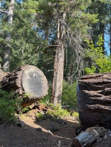
The huge log that fell during a storm that needed to be crosscut out. (Kelly Cleman)
Strong hikers and backpackers can continue walking to Jefferson Lake and beyond. Old-growth forest returns past the lake turnoff. The 9-mile length includes only 1020 feet of gain up to its intersection with the Cabot Lake Trail, so the uphill is very gradual. Year-round water can be found at an outlet from the lake and farther up at Lava Springs.
To read more about the restoration work done on this trail, view The Nugget Newspaper article by googling “What’s Going on with the Jefferson Lake trail?” To volunteer with SECT, email markscottpe@gmail.com.
If You Go
Go in the spring for flowers and in the fall when the vine maple leaves turn color. Since several miles of this trail are unshaded, it can get hot by mid-morning in late spring and summer.
Directions to the trail can be found by using the mapping application on your phone. All roads to the trailhead — both paved and gravel — are in good shape for passenger vehicles.
Be sure to use a good paper map to help you navigate such as National Geographic’s Mt. Jefferson/Mt. Washington map. You can also download an electronic version on the Avenza app or use mapping apps such as All Trails, ONX or Gaia.
After your hike, explore the nearby Metolius Fish Hatchery followed by ice cream at the Camp Sherman General Store or a meal at the restaurants in the area.
Marketplace


Enter the $5,000 Sweepstakes

-
eEdition

-

-