Peterson Ridge Trail: Sisters’ answer to Phil’s — without the crowds
Published 2:44 pm Thursday, June 12, 2025


Sandwiched between U.S. Highway 20 and Three Creeks Road, occupying several square miles of land one minute’s drive south of downtown Sisters (and none too far away from effluent ponds that service the town’s sewer system), the Peterson Ridge Trail is something of a miracle in trail construction.
Prior to about 17 years ago, the PRT was a very basic out-and-back jaunt, created in 1989 to connect logging roads. Its single-track terrain was 10 miles in length, with a quick turnaround at the top of a 700-foot (give or take) climb. In the shadow of Bend’s A+ mountain biking scene, including the sprawling Phil’s Trail Complex, the Deschutes River Trail, Mrazek Trail, etc., Sisters’ contribution was less than an afterthought to the fat-tire community.
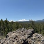
The average mountain biker can reach the Peterson Ridge Overlook (approximately 7 miles of single track) with relative ease, and the view is worth the sweat. (Jeremy Dickman)
Since 2008, after the fledgling Sisters Trail Alliance completed a remodel, the PRT consists of more than 30 miles of trails, dozens of possible loop combinations, and even a few bike-park features to keep the dragonslayers awake.
Used by all
You will find everyone on this trail. Semi-professional mountain bikers? Toddlers on striders? Your grandmother walking her Shih Tzu? All present. Particularly on a beautiful holiday weekend, be ready to hone your trail etiquette. (Among the rules: Yield to foot and uphill traffic, no motorized vehicles or equines and be kind to grandma and her Shih Tzu by slowing down as you approach.)
During the pandemic, as I worked from my home in Northwest Sisters, the PRT was a frequent lunchtime destination. “How did you manage a mountain bike ride at a 30-mile complex during your lunch hour?” some may ask. The trick — aside from stretching that one hour to two — is in the PRT’s ingenuous “ladder” system that allows you to create different loop lengths.
From the trailhead parking lot just east of Elm Street/Three Creeks Road, trail users are offered the option of the lengthy, south-north routes “PRT East” and “PRT West.” Short connectors line the route to link the two north-south trails.
“Dog Walker,” “Tin Can Alley,” and “Running Elk” are a few of the east-west rungs on the ladder that mark opportunities to bail out and create a custom loop. Dog Walker — with a round trip of around 1.5 miles — may be ideal for grandma and the toddler. Top Rung, the final ladder connection at the southern terminus of the PRT system, brings competitive cyclists home at around 20 miles and roughly 1,000 feet of climbing, assuming they aren’t tempted by detours. Like I said, the PRT caters to all.
For my 12-year-old son and I, the mileage calculation was skewed a bit. We exercised our Sisters-resident privilege and hit the trail from a starting point at our front door. Accessing the PRT from the Whychus Tie Trail near Whychus Creek, we added roughly 7 miles or so to our trip, but in so doing saved the hassle of parking, or me teaching my son new profanity thanks to the aging trailer hitch rack system that I refuse to replace with an upgrade.
Best practices
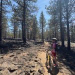
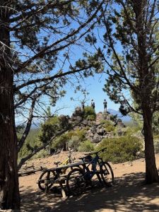
The best practice for two-wheel users on the PRT is to head uphill on PRT West and downhill on PRT East. PRT West is rockier, windier, and less conducive to a fun downhill. The initial four or five miles of the PRT circles through a ponderosa pine forest that retains some greenery and wildflowers in May. As you climb, the rocky cliffs and ridges become platforms of beauty. Your sweat and cardiac stress is eventually rewarded with the Peterson Ridge Overlook, where you’re greeted with breathtaking views of all Three Sisters, Mount Washington, Mount Jefferson, Black Butte, Three Fingered Jack, and a massive carpet of forest leading up to each peak.
From the overlook, you can access several more miles in trail-riding to the Hello Kitty (keep an eye out for cougars!) and Top Rung connectors. But my son had managed a full 50 minutes of zero complaining, and this was a streak I wanted to maintain. Accordingly, we bailed out at the Turkey Hollow connector, and sped down PRT East with aplomb.
Perhaps the marquee feature of the PRT East’s downhill experience is a rollercoaster section near the Double Ditch connector. It drops around 100 vertical feet in just a few hundred horizontal yards, swooping in zig-zag fashion along a ridge, and between century-old ponderosas. My right shoulder still clicks thanks to a nasty spill on this portion of the trail a decade ago, but even that hasn’t soured me on it. Still, I recommend riding within your limits.
The entire trail system is replete with numbered signs at each intersection, so it’s virtually impossible to get lost. Races are common, and so are trail conflicts, so, again, be prepared to yield.
The Peterson Ridge Trail complex can be accessed by turning south on Elm Street from Cascade Avenue in downtown Sisters and driving approximately ½ mile from town. The parking lot on your left will be small and unpaved but loaded with maps at the trailhead kiosk.
Final pro-tip: The best way to win over an emerging teenager to a long trail ride is to promise ice cream at the end. For that, you can do no better than The SweetEasy Co., a straight shot northward from the trail head on Cascade Avenue in Sisters.
My son ordered rocky road with a grin; a pun-loving father couldn’t be prouder.
Best of the Best of Bend 2025

-
-
-