Horse Butte
Published 4:00 am Thursday, February 17, 2011
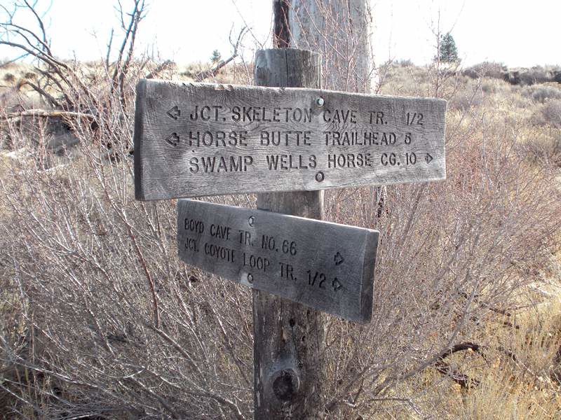
- Trail signs like this are not found at every trail crossing. If you see this one, you're on the right track.
Winter trail running in Bend can be frustrating. Spectacular high-country trails are covered in snow. Forested midelevation trails can be muddy. Urban river trails are populated. But there’s another option, just 10 minutes out of town that offers a solitude-seeking runner (or hiker or mountain biker) a genuine High Desert experience.
I occasionally drive to Horse Butte, a few miles southeast of Knott Landfill, where a network of trails crisscrosses the open country. My dog runs joyfully (and legally) off-leash beside me.
The Arnold Ice Cave Trail-Coyote Loop Trail starts next to Horse Butte and traverses the burn where the 1996 Skeleton Fire scorched 17,000 acres, opening up expansive views in every direction. Smith Rock glows up north. Endless sagebrush, distant trees and small buttes cover the landscape east and south. The Cascades range sweeps the west, the only boundary between me and forever.
On clear days, the Cascades Mountains are breathtaking for much of the run, making it hard to lock my eyes on the narrow trail peppered with ankle-rolling rocks and tussocks of grass. When I hit the trail with a friend on Sunday, the mountains were obscured by clouds, the forefront of this week’s big storm. Often when the mountains and Bend are in the middle of some winter weather, it’s drier out east, and on Sunday we ran through spells of sunshine.
The trail had some soft, sandy spots and a couple of muddy patches, but was generally hard-packed dirt, a great running surface, which is typical this time of year unless the region gets a serious dumping of snow, such as Tuesday’s massive snowfall.
I rarely see more than two or three other people on the entire 10-mile loop, but it lures dog walkers, mountain bikers and horseback riders. After the first couple of miles, the houses on the horizon disappear and it begins to feel pretty remote, a little adventurous. I’ve been passed by bounding deer more than once. Most of the time, the wind is the only sound in my ears.
However, as you approach Coyote Butte, it’s not uncommon to hear shotgun blasts, which justifiably makes some runners uneasy.
Wildlife Biologist Steven George, with Oregon Department of Fish and Wildlife, said there’s a target-shooting area in a cinder pit at Coyote Butte, and that’s typically what trail users hear. However, it’s worth noting that hunting is allowed on the multiuse public land. Coyotes, an unprotected species, can be hunted in the area all year, but that’s infrequent, George said.
In any case, runners, hikers and bikers should be aware that it’s legal to discharge firearms on the public land. I wear neon orange or green running tops whenever I go, and I avoid the area during deer hunting season, the first half of October.
George also said that during a trapping season between November and March it’s legal to place unmarked, unflagged traps in the area, so it’s wise to keep off-leash dogs close to the trail.
It’s also wise, I say from experience, for anyone exploring the area for the first time to go with friends, carry extra water and tell someone when they plan to return. Trails are windy, can be confusing, and many crossings are unmarked. Snow can make things even more confusing. My cell phone works out there, which I was thankful for the first time I explored, got turned around, and wanted to let my husband know that I was going to be home later than planned.
Because of the high, open terrain, however, it’s easy to get directional bearings by paying attention to where the mountains are (west), even if they are behind a wall of clouds. Also, Horse Butte itself — which is where your car is — is a memorable red hill of cinders that you can see from many points on the gently-rolling trail.
How to find it:
After your southbound car reaches the end of the paved Horse Butte Road (see “If you go”) and starts bouncing along the bumpy dirt road (Forest Service Road 1815), watch for a Horse Butte Trailhead sign that points to the right. The junction is right next to Horse Butte. The small dirt road is signed as “800.” Drive about a half mile down the 800 road to the official trailhead for the 10-mile loop. There’s ample parking.
From the parking area, the trail backtracks (eastward) on the 800 road. Cross Forest Service Road 1815. Just a few feet north, pick up the single track dirt trail and start running eastward for a big clockwise loop. The main trail is pretty obvious, and when in doubt, go straight through trail intersections. After a few miles of gentle climbing up a couple of ridges, you’ll see a signed intersection (see photo) that says you’ve come five miles from the Horse Butte Trailhead, and indicates that the Coyote Loop Trail goes right. The trail eventually crosses the gravel Forest Service Road 1815 again and leads through the woods back to the original trailhead. (This is the course for the annual spring Horse Butte 10-mile run, which is limited to 200 racers.)
An alternate option: If you want to shorten the distance a little, as I frequently do, park immediately next to Horse Butte, at the junction of the 1815 and 800 roads. Toward the end of the run, instead of crossing the 1815, cut back right (north) on the big gravel road until you see your car at the parking area next to Horse Butte. That’s probably at least an 8-mile run. There’s an obscure trail that runs parallel to the 1815 too, if you can find it before you hit the road, to avoid running on the road. But that one takes some exploring to find.
Don’t forget to carry water, and a map could help. “Treadmaps, Central Oregon, Part 2” covers the area. See www.treadmaps.com for information about which local stores carry the map.
Average and slow runners need about two hours to run the loop, solid hikers can walk it in three hours. About 90 minutes is plenty of time for the average mountain biker.
If you go
What: Arnold Ice Cave and Coyote Loop trails via the Horse Butte Trailhead
Getting there: Go south on 27th Street past Knott Landfill to Rickard Road, turn left. Go two miles east on Rickard Road, then turn right on Billadeau Road, which turns into Horse Butte Road. This road becomes gravel, and is marked by a Deschutes National Forest sign. Continue until you see the Horse Butte trailhead sign. Turn right and park. You might not realize it because of scarce signage, but the first part of the loop is the Arnold Ice Cave Trail. The latter part is listed as Coyote Loop Trail.
Cost: Free
Difficulty: Moderate. It’s a long trail and you have to watch your footing.
Contact: Bend- Fort Rock Ranger District, 541-383-4000
More Local News


Best of the Best of Bend 2025

-
-
-