Central Oregon apps
Published 4:00 am Wednesday, December 15, 2010
- Central Oregon apps
You can follow basketball in Poughkeepsie and find the best cocktail lounges in Portland, but search your smart phone for Central Oregon-specific applications and the list is going to be short.
And local techies say that’s no surprise.
Smart phone use grew here only within the last six months, they say, as 3G coverage in the High Desert improved. And writing software for such devices, known as applications or “apps,” can be a time-consuming affair.
Yet in the near future, they say, expect to see more locally oriented apps available for both Apple and Android products.
“It’s coming really soon,” said Jack Robson, president of Bend-based software firm Nimble Development. “We’ll talk a year from now and there will be tons of apps on Central Oregon.”
Those who develop Central Oregon apps initially will likely be locals who do so as a hobby, not as part of a commercial venture.
One such dabbler is Sunriver-area resident Michael Harper, whose day job is software development. For fun, however, he crafted one of the few local apps out there, a road and bike trail guide to Sunriver Resort called Circle 8. The project took months to launch: He biked the whole resort carrying a GPS, wrote the app and then awaited Apple approval. It first went up in Apple’s App Store in September.
He said soon after the launch, feedback streamed in asking for more local content.
“Hiking trails, Phil’s Trail, those are the kinds of things people want to see apps for,” Harper said.
“I think it’s going to happen as more people move into the area,” he continued. “There will be more tech-savvy people here. They will see issues and say, ‘I wonder if there’s a technical solution for that.’”
In the meantime, there are a few more apps on the market that aren’t exclusive to Central Oregon, yet offer useful local information. The key to finding them is making broader searches in the App Store or Android Market. Instead of “Mt. Bachelor,” type in “ski Oregon.”
Or you can always try creating one yourself.
That’s what Cory Pratt did. The Bend resident took about seven months to craft The Hatch and The Hatch Lite, Apple apps that give anglers information on their favorite rivers.
Pratt encourages others to give it a try.
“There’s enough resources out there on the Internet and in books for someone who understands programming to do it.”
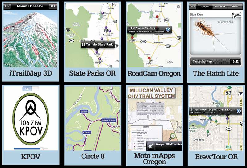
Want to find your way on the slopes or to the nearest frothy brew? Here are a few of our favorite apps providing cool tools for Central Oregon living:
Circle 8
Compatibility: iPhone, iPad and iPod touch, requires iOS 4.0 or later Price: $1.99 Last updated: Dec. 10 Other versions: None What it does: Circle 8 is like a Google map but better; it also includes roundabouts, bike paths and key locations throughout Sunriver Resort. You can also search for locations (where is the North Pool?) and intersections, and then zoom in on your target. And with the new GPS component the app can pinpoint your location within the resort. Who is it for: For anyone who has ever blundered through Sunriver Resort as Clark Griswold does London, this app is for you. It’s also a must-have for tourists. Cool factor: It’s named after the missing roundabout in the Sunriver Resort road system, Circle 8. After researching why the circles jump from 7 to 9, app creator Michael Harper now believes the resort planned No. 8, but then gave up the land in a deal with the U.S. Forest Service. The local joke is that when unpleasant visitors ask for directions, tell them to take the first left at Circle 8.
The Hatch Lite
Compatibility: iPhone, iPad and iPod touch, requires iOS 2.2.1 or later Price: Free Last updated: Nov. 20, 2009 Other versions: Information for rivers in more than 30 states is available on The Hatch, which costs 99 cents. What it does: Want to know which flies are likely best on the Crooked River in June? Align these two elements and click. A list of flies will appear. When you choose a fly, a picture pops up, as well as the suggested sizes and recommended patterns. The app covers several of the most renowned fly fishing rivers in Oregon, including the Lower Deschutes, Middle Deschutes, Fall, Crooked and Metolius. Who is it for: Local anglers and visitors alike will appreciate the tips on how to pack before setting out. And if you need to change strategy on the go, the app is a good guide. App creator Cory Pratt also advises it’s best paired with advice from local fly shops, which always have the most up-to-date info. Cool factor: Bend resident Pratt designed the app himself, with advice from area anglers and fly shops.
RoadCam Oregon
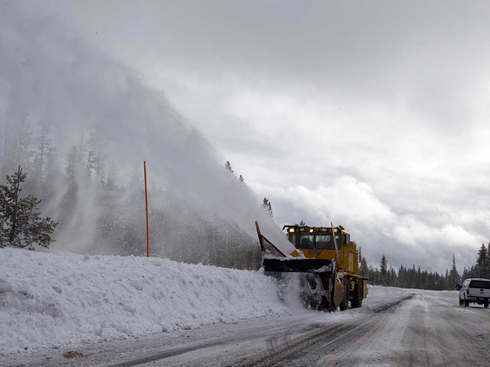
Compatibility: iPhone, iPad and iPod touch, requires iOS 3.0 or later Price: $1.99 Last updated: Aug. 5 Other versions: None What it does: Check how blustery the Santiam Pass is as you approach. With just a tap, this app connects users to the Oregon Department of Transportation’s video cameras along highways throughout the state, including Central Oregon and the mountain passes. Users can also create a favorites list for even speedier navigation. But you must have a signal for the app to function. Who is it for: It’s a no-brainer for anyone driving over the Cascades in winter. Cool factor: ODOT’s Web cams also list temperature and wind speed at the locations.
iTrailMap 3D
Compatibility: iPhone, iPad and iPod touch, requires iOS 3.0 or later Price: $4.99 Last updated: Nov. 16 Other versions: Another version called iTrailMap is also available for free in Apple and Android versions, but they are essentially downloaded ski area maps. They don’t require a cell signal — handy for midmountain — but don’t have nifty GPS components. What it does: First, you download ski area maps — the app offers all the areas in Oregon, including Mt. Bachelor, Hoodoo and the Mt. Hood resorts. If that’s all you want, snag a free version. But for the price of a mega latte you can get more. Lost in the trees below Bachelor’s Northwest Chairlift? If you get a signal, you can locate yourself and where the nearest ski run is with the GPS function. Throughout the course of the day you can also track total vertical, miles skied and other stats, shooting it later to Web site www.3dskier .com to gloat over your day. Who is it for: If you’re just as comfortable grasping a phone with frigid hands as a paper map, this app is for you. The GPS factor can be extremely helpful, but don’t count on a signal always being available, even on well-serviced mountains like Bachelor. Cool factor: Planning a European ski vacation? Or a Utah getaway? iTrailMap’s library of available ski areas is massive. But you’re still out of luck for a few regions, such as Alaska or Scandinavia.
Moto mApps Oregon
Compatibility: Android devices Price: $1.99 Last updated: Dec. 3 Other versions: There is a free version that offers maps only but no GPS capabilities. What it does: This is the app for nonwinter motorized recreation. It functions much like iTrailMap 3D, offering GPS function, trails and directions for motorized trails. And it includes major riding areas around Central Oregon, such as Millican, East Fort Rock and Santiam Pass. Who is it for: Again, folks who feel just as comfortable with digital as with paper will like the palm-of-your-hand convenience. Cool factor: Android device owners finally get in on the fun. And the on-screen compass is an excellent plus.
KPOV
Compatibility: iPhone, iPad and iPod touch, requires iOS 3.0 or later Price: Free Last updated: July 19 Other versions: None What it does: Plays what’s on now at Bend’s listener-supported radio station. Who is it for: Anyone who wants a mini-radio in their pocket for when the usual playlist gets dull. Cool factor: Finally, an app even a Luddite can love. This app is ridiculously simple to use: Turn to on. Volume up or down. That’s it.
State Parks OR
Compatibility: iPhone, iPad and iPod touch, requires iOS 3.0 or later Price: $1.99 Last updated: Nov. 25 Other versions: None What it does: This is a digital encyclopedia of Oregon state parks, including those throughout Central Oregon. While it doesn’t map trails, it can give you the basics on any park, from fees to hours to boat launches. Who is it for: If you’re relatively new to the region and eager to explore, you’ll appreciate the all-in-one-place pile of information. But if you’ve been going to, say, Smith Rock State Park for years, this may not tell you too much that’s new. Cool factor: Who knew La Pine State Park is home to the state’s largest Ponderosa pine tree?
BrewTour OR
Compatibility: iPhone, iPad and iPod touch, requires iOS 3.1.2 or later Price: Free Last updated: April 8 Other versions: None What it does: What if you don’t know where to find the nearest brewpub? BrewTour OR uses GPS technology to guide you there. You can also search by Oregon city. If you select a listing, the app shows you the pub’s hours, location, website and possibly other interesting info, like the name of the head brewmaster. You can also create your own beer database to remember your favorites. Who is it for: Those who — reasonably so — can’t keep Bend’s umpteen different brewpubs straight in their heads. But it will not tell you what seasonal is on tap. Cool factor: It’s not hard to figure out … it helps you find fine craft beer.
Terms to know
Smart phone: A device that lets you make phone calls but also offers features that you might find on a computer, such as the ability to send and receive e-mail, edit documents and access the Web.
iOS: Apple-based operating system. It’s the same “i” that’s used in iPhone and iPad.
App: Short for application. An app is a software program designed specifically for a device like an iPhone or an Android smart phone.
Sources: Michael Harper, www.wisegeek.com, www.about.com

Best of the Best of Bend 2025

-
-
-