Steens like you’ve never seen before
Published 5:00 am Thursday, September 17, 2009
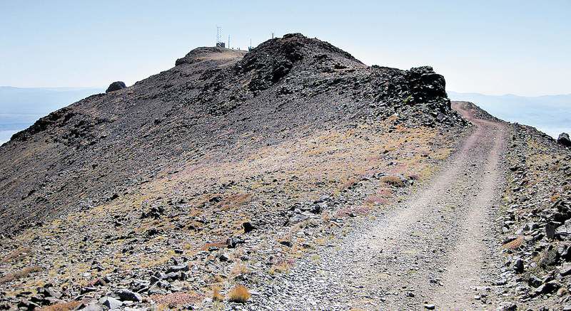
- The unpaved North and South Loop Roads create a 66-mile loop with a short detour to the top of Steens Mountain. From the parking lot, this easy, half-mile dirt path leads to the antennas marking the summit.
Shhhh! Don’t tell anybody, but there’s a road to the top of Steens Mountain.
So really, there’s no reason to hike an 8-mile-long gorge to reach the biggest dead end you’ve ever seen, then climb 2,000 feet pretty much straight up to get to the summit.
Trending
Unless, of course, you wanted to.
Steens Mountain is a massive hunk of rock in southeastern Oregon that would probably look taller if it wasn’t so wide. At 9,733 feet, Steens ranks as the ninth-highest peak in the state, and the highest non-volcano in Oregon outside of the Wallowa Mountains. That puts it somewhere above Broken Top and Mount Bachelor but below the Three Sisters.
But because the mountain stretches for 30 miles, it doesn’t have the vertical orientation of some of the more familiar summits in the area. Tucked into a remote corner of the state, it’s probably one of the more overlooked mountains in Oregon.
Steens is a fault-block mountain, formed when large areas of bedrock are broken up by faults, creating large vertical displacements of the continental crust. Massive underground forces pushed the eastern edge of Steens upward, resulting in a spectacular, rugged east face that rises one-vertical mile above the Alvord Desert.
During the Ice Age, glaciers dug trenches about one-half mile deep through the layers of hard basalt of Steens Mountain to form four immense, U-shaped gorges: the Kiger, Little Blitzen, Wildhorse and Big Indian.
The gorges themselves are worth a trip. But I came with the intention of hiking the Big Indian Gorge and then climbing up its steep walls to the summit.
Trending
The trail starts at the South Steens Campground, about 17 miles from the nearest paved road. The washboard road to the campground is rough but passable, even without a high-clearance vehicle.
From the trailhead, the first three miles toward the gorge follow a nice trail, crossing a few streams on the way, before entering the gorge itself.
It’s easy to see how much difference water makes to an arid landscape. Where Big Indian Creek and its tributary streams run, they form oases of greenery, often with beautiful groves of aspen trees. According to the book “75 Scrambles in Oregon” by Barbara Bond, the mature aspens in a grove at the four-mile mark contain “decades-old” carvings by a Basque sheepherder. Unfortunately, those carvings are now lost among the graffiti of dozens of other hikers with knives, such as KB expressing undying love for JD. I’m guessing that relationship didn’t last nearly as long as the damage to the tree. If you need to express yourself, get a tattoo and leave the trees alone.
As you hike farther into the gorge, it’s hard not to look up at the half-mile high walls to each side of you. Low bushes start to encroach on the trail after three or four miles, giving your legs a bit of beating as you push through. At about the seven-mile mark, the trail fades away and you’re left to hike cross-country. But at that point, you’re face to face with the massive east wall of the gorge.
If you’re going to tackle the climb, get Bond’s book, which has a better description of the route than I have room for here. I took a bit of a detour, heading up the southeastern end of the gorge (instead of heading up northeast as Bond recommends), then traversing to the south ridge.
At the start of the ridge, I ran into a hunter perched high above a mountain lake, looking for bighorn sheep. I’m not morally opposed to hunting, but I do revel in the chance to see animals in the wild. He was friendly enough, even pointing me toward the trail on the ridge, but I was hoping he wouldn’t be successful that day.
The south ridge trail runs probably about a mile, eventually connecting with the trail up from Wildhorse Lake, just before it reaches the parking lot at the end of the road. There’s a certain loss you feel after hiking for hours and then reaching the outlying tentacles of civilization. I felt that way as I passed the half dozen cars in the parking lot, to climb the final half-mile to the antennas and cell phone towers on the top.
I had come 13 miles, and 4,500 feet up. Yet was only half way done. The descent back down the gorge would have taken just as long as coming up, so I resigned myself to hiking down the road 12 miles to get back to the campground. It’s not the most pleasant way to descend a mountain, but I had a long drive back to Bend that afternoon, so I needed to take the shortest way down.
I was actually hoping that someone might offer me a ride down, and gave a friendly greeting or wave to all the drivers as they milled around the lot. But none asked about my intentions or offered a spot in their car.
So I headed down the road, counting my progress in 20-minute sections, which I figured was about a mile. The road was dusty, but the views of the Big Indian Gorge were a fine distraction. At least for the first hour.
About two hours in, with probably another two hours and six miles to go, a silver pickup pulled up by side.
“How are you feet holding up?” the driver, Norm, asked.
I saw my chance. My feet were actually fine, but truth be told, I was bored walking down the dirt road.
“Oh, they’re hurting!” I said laughingly.
“Would you like a ride? Feel free to hop in the back,” he replied. “There’s a cooler back there, with cold water, soda and beer. Help yourself to whatever you’d like.”
It was without a doubt the finest act of humanitarianism I had ever witnessed.
OK, that might be the beer talking, but I really appreciated his kindness.
Norm and his wife, Pamela, were up from Mt. Angel touring the Steens Mountain Loop, a 66-mile road that includes the detour to the summit. The rough road meant a slow, 40-minute descent for the final six miles, but I enjoyed the clear blue sky and the dramatic views of the gorge.
They dropped me at the entrance to the campground, where, after much thanks, I walked a final quarter-mile to the car. But let’s keep the fact that I hitched a ride halfway down the road our little secret.
After all, there’s no reason to hike all the way back down Steens Mountain on a road.
Unless, of course, you wanted to.
If you go
Getting there: Follow U.S. Highway 20 east to Burns, continue on state Highway 78 for two miles past Burns. Turn south on state route 205 through Frenchglen, about 10 miles to the Steens Mountain South Loop Road. Follow the unpaved road about 17 miles to the South Steens Campground (toilets, water, $6 camping fee). The trail starts at the east end of the campground, just past the group camping area. Alternatively, follow the Steens Mountain South Loop Road another 12 miles to the summit parking lot.
Difficulty: Difficult 25 miles round trip, 4,500 feet elevation gain. (Easy trails from summit parking lot.)
Cost: Northwest Forest Pass
Contact: BLM Burns Office, 541-573-4400
Marketplace


Enter the $5,000 Sweepstakes

-
eEdition

-

-