Forest officials mapping legal off-road trails
Published 4:00 am Tuesday, January 27, 2009
- Forest officials mapping legal off-road trails
Deschutes and Ochoco national forest staff are cataloguing more than 10,000 miles of open forest roads and designing new motorized vehicle trails, in preparation for drawing and implementing new maps that show where off-roaders may drive.
The new maps are expected to be out in December.
It’s all a result of the U.S. Forest Service’s nationwide travel management rule, published in 2005.
The rule will make it illegal for off-roaders to drive cross-country or on routes that aren’t specifically designated as open. That’s a switch for the Deschutes National Forest, which is open to motorized vehicles unless it is specifically closed.
The rule requires all national forests to publish maps that show the routes, trails and areas where people can ride their motorized vehicles. Other areas on Forest Service land will be off limits.
The national forests in Central Oregon started taking public comments on the rule in 2006, and are scheduled to have a draft of the local environmental impact statement in late spring or early summer. The new maps are due at the end of this year.
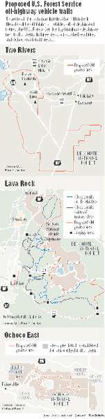
Because of this rule — which will close off many areas where people used to ride motorcycles, quads and other vehicles — the Deschutes and Ochoco national forests are considering three new trail systems: west of the Newberry National Volcanic Monument, southwest of Crescent and east of Prineville.
“A lot of the reasons why we’re doing these projects is because of the implementation of the travel management rule, which will prohibit travel off of designated routes,” said Mollie Chaudet, travel management project leader with the Deschutes and Ochoco national forests.
The agency is taking comments about the proposed 150-mile Lava Rock trail system near Newberry, and working to determine possible trail routes in the Two Rivers area near Crescent and the Ochoco East area.
Sites already set as off-highway vehicle play areas, such as the East Fort Rock area, or trails and roads that are already officially open for vehicles will remain open. The rule only impacts Forest Service land.
“We’re really looking at, across both forests, where we can provide for different trail opportunities or areas to get off of the road system,” Chaudet said.
The reasoning
The goal of the travel management rule is to provide consistency across national forests — all the maps should look similar across the country, she said. For example, they will be black and white.
The rule is also designed to help stem the damage that motorized vehicles can do to soils, vegetation and other resources in forests, she said, as well as to designate trails that will improve the recreation experience for riders with trails designed for different experience levels.
Beyond the new trails, Forest Service staff are spending lots of time entering information about the existing status of stretches of roads to generate accurate maps of the open roads, Chaudet said.
Another element of the travel management covers how people can drive to dispersed campsites, or campsites that don’t have facilities like toilets, fire rings or picnic tables, many of which are some distance from roads.
Last summer, the Deschutes and Ochoco national forests proposed a plan that would allow campers to drive 300 feet off open roads to get to campsites, Chaudet said.
But in certain sensitive areas, people would only be allowed to use existing sites and not make new ones.
“Where we have either a lot of high use or they’re more sensitive areas, we really want to limit folks from existing sites,” she said.
The reaction
Some people have written in, concerned that riders could abuse the 300-foot rule and drive off-road that distance without intending to camp anywhere, Chaudet said.
People also have expressed general concerns about the rule and the elimination of cross-country travel, she said. But that’s not something the local Forest Service can change, she said.
“They’re asking that we just leave everything open, and that’s not consistent with what the rule tells us to do,” Chaudet said.
Others are pleased that the travel management rule will limit travel to designated routes.
Marilyn Miller, with the Sierra Club’s local chapter, said while she has concerns with some of the proposed designated trail routes, making cross-country travel off-limits is something the Forest Service should have done decades ago.
“They did quite a bit of damage,” she said of off-road vehicles. “The soils are too fragile.”
Larry Ulrich, president of the Ochoco Trail Riders, said the rule could pose problems, however. People have been riding off-road for decades in Central Oregon, and he estimated there are thousands of user-created trails in the forests that will now be off-limits, funneling all the riders onto the designated trails, which could become overcrowded.
“It’s always been an open forest; you could ride wherever you wanted to,” Ulrich said.
The rule allows the Forest Service to make the user-created trails official, he said, but the environmental analysis needed to do so is often prohibitively expensive for the agency to fund.
But the maps can be changed in years to come, said John Allen, Deschutes National Forest supervisor. As the number of people using the trails changes, or Forest Service staff learn more about the impact to the area’s natural resources, the map could be altered.
“I would say the map isn’t static,” Allen said.
To comment on the travel management plan, write to Mollie Chaudet, Deschutes National Forest, 1001 S.W. Emkay Drive, Bend, OR 97702.
For more information, visit www.fs.fed.us/r6/centraloregon/travel-mgmt/index.shtml
More Business


Best of the Best of Bend 2025

-
-
-