Highway 22 : Gateway to Santiam
Published 5:00 am Thursday, October 1, 2009
- Highway 22 : Gateway to Santiam
Driving home from Portland on Monday, I hoped to spot signs of fall. The area around Detroit Lake and along the Santiam River can offer a showcase of colors at the right time.
Unfortunately for me, I think we missed the show by a week or maybe even a few days. A few dots of yellow and red appeared here and there, and I could tell the whole area was about to explode with color.
Trending
So, with our plans for a fall color tour put off a bit, my husband and I decided to go for a hike. After nearly two hours in the car, Detroit Lake seemed like a perfect place to stop and get a breath of crisp fall air.
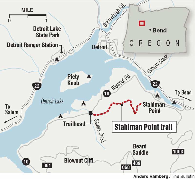
We stopped at the local Forest Service Ranger Station, located just to the west of Detroit on state Highway 22. We walked in with little knowledge of the area and zero ideas about hikes. The staff members at the ranger station were friendly and helpful. After telling them briefly about what we were looking for — nothing too long, nothing too far away from the highway — they recommended we check out Stahlman Point and handed us a flier with details.
This experience was a great reminder. To prepare for most hikes, I spend up to an hour pouring over outdoor guidebooks, searching for the perfect option. Asking staff at the ranger station took far less time. It was also fun. Maybe once in awhile I should go on a hike without expectations, just go with a quick recommendation and the information handed to me. Ranger stations operate this way and are designed with recreational hikers in mind, so this is a resource I plan to keep in mind in the future.
We found the trailhead for Stahlman Point a few miles east of Detroit at the far east end of the lake. We crossed a bridge and drove along the southern shore for a few miles and found the trailhead on the side of the road.
The weather was a treat. Although most of the leaves clung to their summertime colors, the air still alerted us that it was fall. The temperature was pleasant and the air was crisp. Days like this remind me that fall hiking can be even more rewarding than summer hiking because the temperature makes it less punishing.
The trail left the small parking area and almost immediately began ascending. Unlike trails in Central Oregon, this path was free of dust, in part because of a blanket of pine needles covering the path.
Trending
The trail took us underneath a giant canopy of trees, including Douglas fir. We saw mossy, spongy patches, leafy clover and plenty of slugs.
For about 2.5 miles the trail steadily climbed. We passed a sweet bubbling creek and a large patch of rhododendrons. As we climbed, we also enjoyed views of Detroit Lake.
To get to the top of the point, we had to scramble up large rocks, which I would not recommend for children or dogs. When I placed my foot on the top of the final rock, I felt a flash of vertigo. I stood on top of a small, flat rocky outcrop that showed remnants of a former lookout. On the other side was a sheer drop off down to the valley below. We saw the highway wind around the lake and river. We saw the lovely hills surrounding the area. And we saw a gorgeous view of Mount Jefferson straight ahead. The mountain seemed nearly bare of snow. But its giant rocky presence was still impressive.
We stayed for a few minutes, enjoying the view (and getting a little freaked out whenever a big gust of wind blew our way) and resting after the steady workout.
The way back was quick, as it was all downhill.
In all, the hike took us about two hours. When we were back in the car heading home, I wondered why we had never stopped in this area before. It is the perfect way to refresh and break up a long car ride.
Not far from Detroit Lake, as the highway curved alongside the Santiam River, we began to see plenty of fall colors. Seems we just hadn’t gone quite far enough. The oranges, reds and yellows burst along the river and on both sides of the highway. Most of the color could be seen on bushes, while the trees held onto their green a bit longer.
If you crave fall color and don’t mind a bit of a drive, consider a trip on Highway 22.
If you go
What: Stahlman Point
Getting there: From Sisters, head west on U.S. Highway 20, at the merger with state Highway 22 stay to the right (follow the signs to Salem). Stay on the highway for about 28 miles and then turn left onto Blowout Road. Follow the road for 3.5 miles. The trailhead is on the left side of the road.
Difficulty: Moderate (be cautious on the final climb if taking children or animals)
Length: Five miles round-trip
Cost: Free
Contact: 503-854-3366


Best of the Best of Bend 2025

-
eEdition

-

-