Keeping a positive altitude
Published 5:00 am Thursday, August 27, 2009
- Black Butte
Its a steep climb over uneven terrain much of the way up Black Butte. Exposed rocks jut out threateningly. Depending on your ability to navigate narrow, high-altitude paths, it can be really slow going.
And thats just the drive. Wait till the hike starts.
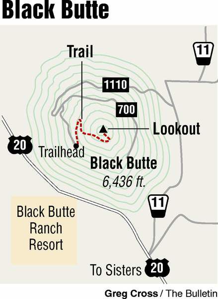
You indeed drive a significant portion of the way up even before hoofing it the rest of the way to the summit of Black Butte, elevation 6,436 feet, according to Deschutes National Forest.
But dont be fooled, would-be hikers. According to outdoor writer William Sullivan, an elevation gain of 1,600 feet complements the 1.9-mile hike to the top.
Your lower extremities wont know what hit them.
Depending on your level of fitness, you may be thinking the word ruin long before you see the remains of an old fire tower and other interesting signs of human presence at the summit. According to Sullivans Web site, Black Butte has an array of structures that includes an intact cupola-style building from 1923, the ruins of a collapsed 1934 tower, and a modern 62-foot tower from 1995. In 1980, a one-room log cabin was constructed in Sisters, disassembled, and flown by helicopter to Black Buttes summit as living quarters for the fire lookout staff.
Last week, armed with scribbled directions, iPod, headphones, one bottle of water, digital recorder, camera and an apple for sustenance, I left work and at least several cares behind and drove from Bend to Sisters to Black Butte under bright sunny skies.
My goal was to reach the summit of Black Butte, an enormous, difficult-to-ignore stratovolcano just off of U.S. Highway 20. After driving by Black Butte many times over the years, Ive had it on my list of must-hikes for a while; the time had come to finally cross it off my list.
En route, however, a delay presented itself in the form of a temptingly situated fast-food establishment located on the far end of Sisters, just off U.S. Highway 20. Nothing like fatty fast food to kick off a hike. Make that a McDouble to go, please. Ooh, and cookies. Cant forget cookies.
At milepost 95, I turned right at the sign for Indian Ford Campground and continued north toward Black Butte, then veered left onto Forest Road 1110 to begin winding my way up to the trailhead at roads end.
Be advised: At its upper reaches, the unpaved road becomes challenging for smaller cars. My vehicles underside didnt audibly scrape any rocks, but thats only because I could have crawled up faster than I drove. I stopped a couple of times to put it in reverse and crane my neck looking for the path of least friction.
Soon enough, I reached the lot and was out of my car and on the trail just before 1 p.m. A smart hiker would have been completing his hike by then, but Im nobodys smart hiker.
A sign about the recent Black Butte II Fire (sequel to an earlier one), is posted at the trailhead. It reads, in part, Hazardous conditions remain. Trees or branches may fall without warning, stump holes may be deceptively deep and hot, rocks may roll easily and other unseen hazards exist.
Fun! Just try to hold me back from the top of this butte!
I was surprised how many flies and bees were gorging on a pungent plant on my hike through the woods.
The first portion is fairly dense with trees, which means shade, or would if you werent hiking at midday. Still, there are enough pines along the trail, even toward the top, to offer some respite from the sun.
Your mind wont be on heat or buzzing insects. With such quick gains in elevation, youre soon enjoying views of Mount Jefferson and Mount Washington and a couple of the Sisters. Theres Hoodoo in the distance, little tiny semis trundling along U.S. Highway 20. Such views are worth at least one slog per summer.
A group of four or five kids with a dog spoke to me as they headed down and I forged up the path, panting and sweating.
Almost there, said one kid who was way too upbeat for the situation. Just 45 more minutes!
Before I could protest, the man bringing up the rear said, Ah, 30 minutes.
I was going to say, 45 more minutes, and I might have to give up, I said.
He replied, Nah, 30 more minutes.
Still. 30 more minutes.
I soldiered on, apparently with the recorder on in my pocket. I have about 30 minutes of the sound fabric makes when it rubs against a digital recorder.
After what felt like days but was probably closer to 10 or 15 minutes, I reached the part of Black Butte affected by the recent fire. Black Butte II was sparked by lightning in early July and consumed 578 acres before it was contained.
Fire retardant still coats trees and rocks and looks a lot like the red goop that was plastered all over everything when the tripods attacked in Spielbergs War of the Worlds.
Almost as soon as youve entered the burn area, though, youre exiting back onto the sunny slope of the butte and almost at the top. Ignore the flies. Those buzzards soaring in the wind are just taking advantage of the wind. Theyre not after you. Keep moving.
The man in the group had been right, as it turned out. I pulled the recorder out of my pocket when I reached the top, exactly 30 minutes after Id encountered the group.
Stunning views of the High Desert and Cascades, as well as plaques describing the buttes various structures, await hikers who reach the top.
Going back down takes a fraction of the time it took to get to the summit. Your legs may feel as if theyre mired in a bowl full of Jell-O, but youll practically run to your car anyway.
I know I did. My car may be too low for dirt roads, but it has one thing going for it: air conditioning.
If you go
Getting there: Follow U.S. Highway 20 west of Sisters 5.5 miles. At milepost 95, turn right toward Indian Ford Campground on Green Ridge Road and continue north on Forest Road 11. Veer left at branch for Forest Road 1110 and follow road to trailhead.
Difficulty: Moderate to difficult
Cost: Northwest Forest Pass
Contact: Sisters Ranger District, 541-549-7700
More Local News


Best of the Best of Bend 2025

-
-
-