Deschutes reconsiders destination resort map
Published 5:00 am Thursday, October 23, 2008
- Deschutes reconsiders destination resort map
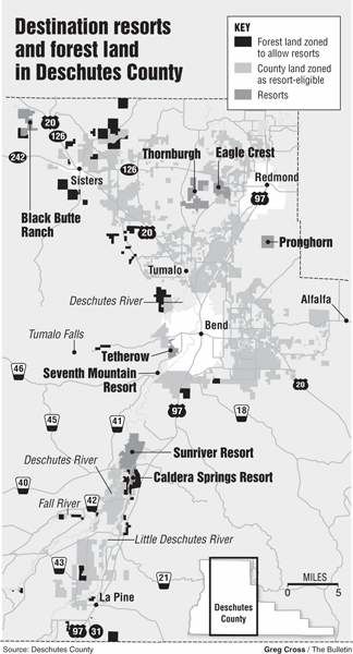
Deschutes County, home to more destination resorts than any other Oregon county, is reviewing its destination resort map for the first time since 1992.
The map shows all the sites where destination resorts can be developed, a total of 112,448 acres. Since 1992, some property owners have rezoned their land to make it eligible for future resorts; however, that is only the first step.
Trending
Before developers can build resorts, the land must be added to the county’s destination resort map.
The process under way now at the county could allow property owners to accomplish that, but it is unclear at this point whether land will be added or removed from the resort zone when the review is finished.
For example, a company that owns portions of the Sunriver Resort and Caldera Springs has rezoned 617 acres of former U.S. Forest Service land north of Vandervert Road to allow for a resort, but it still needs the county to add the property to the map before it can build.
Owners of a 179-acre forest land parcel south of Vandervert Road have also applied to the county to rezone that land.
Residents can give their opinions on whether the county should add or remove land from its resort map, and how it should do so, during a discussion at 5:30 p.m. today before the Deschutes County Planning Commission.
Senior Planner Terri Hansen Payne said the county is at a “big-picture stage” in the process. Officials need feedback from the public on how they should deal with requests to add or remove land from the map, among other issues.
Trending
“Right now, we’re just trying to get a feel for how the community feels we should deal with resorts and where they are located,” Payne said.
Six to 18 months down the road, the Deschutes County Commission will become involved in decisions on how to change the map, Payne said.
The destination resort map is just one element of the county’s comprehensive zoning plan, which guides how land will be developed and was first adopted in 1979.
Until 2003, Oregon counties could not alter their destination resort maps. That year, the state Legislature passed a law allowing counties to remap destination resort zones. The state requires counties to adopt a process for remapping, and they must wait at least 30 months between updates.
Tom Luersen, the Pacific Northwest regional managing director for Lowe Hospitality Group, which manages the Sunriver Resort, was not available to comment Wednesday on any plans related to the rezoned 617-acre parcel.
Pam Hardy, an attorney for Central Oregon LandWatch who argued against the rezoning, said a lot of landowners want to rezone forest land to make it eligible for the resort map.
“Just about the only thing it does for them is it gives them the legal right to ask for it,” Hardy said of rezoning.
If you go
What: Destination resort discussion, as part of Deschutes County’s comprehensive plan update
When: 5:30 p.m. today
Where: 1300 Wall St., Bend
By the numbers
112,448: Number of acres in Deschutes County zoned for destination resorts
52 percent: Portion of Deschutes County that is forest land
12,738: Number of acres of forest land where resorts are allowed
Source: Deschutes County
Marketplace


Best of the Best of Bend 2025

-
eEdition

-

-