10-Mile Sno-park
Published 4:00 am Friday, January 5, 2007
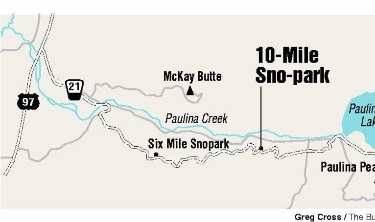
- 10-Mile Sno-park
Map Guy got new cross-country skis.
Once clicked in and under way, he seemed transformed, at the top of his game or maybe even somewhere a couple of switchbacks above it. He skied more gracefully, endured the climbs more graciously and bombed downhill with more bravado than I can remember. I was impressed. So was he.
Map Guy’s newfound athleticism and almost cheery attitude notwithstanding, it was good to be out on the winter trail again, discovering the magic of 10-Mile Sno-park with the fellow who has fielded my published barbs (more or less) affably for the past half-dozen years.
You come first to 6-Mile Sno-park along the road to Newberry Crater. It’s often plagued by a spotty snowpack; this day was no exception. So we continued the four additional miles to 10-Mile, which at 5,560 feet, usually has plenty of snow.
A multiple-use sno-park, 10-Mile caters to both snowmobilers and nordic skiers. While there are some shared corridors along the trail system, there are plenty of blue diamond trail miles that take skiers into that pristine realm they’re looking for. The snowmobilers we crossed paths with were courteous to a fault, slowing way down to pass us and exchanging pleasantries. The La Pine Lodgepole Dodgers Snowmobile Club has built a super-roomy and cushy warming shelter near the parking lot where winter sports enthusiasts can thaw out and socialize. Club members provide the wood and put in many hours of volunteer time.
”The club worked very, very hard building that shelter,” said spokeswoman Peggy Spieger.
There are two main cross-country ski trails out of 10-Mile – Paulina View Trail and Ponderosa Rim Trail. Both snake up the mountain through a mixed-conifer forest. It’s about 3.5 miles to Paulina Lake (7 miles roundtrip). As the Forest Service so aptly explains, if you are headed toward a volcano’s crater, up is the only way to go.
”Newberry is what we call a v.b.v. (very big volcano),” according to the blurb from the Bend-Fort Rock Ranger District of the Deschutes National Forest on the back of the take-and-go trail map.
I found that to be a fair assessment, although Map Guy was uncharacteristically silent on the subject.
Newberry, one of the largest volcanoes in the United States, covers about 500 square miles. And, as per the Forest Service, ”views from the Cascade Range pop out in the most unexpected places.”
They really do. Turn and look west along the Ponderosa Rim Trail and you can see the Cascade peaks out across the valley. You can also see the recognizable rocky head of Paulina Peak loom in and out of view.
We skied on both trails, appreciating the ambience of each.
Both trails eventually end up near Paulina Falls and the crater rim. Ponderosa Rim Trail crosses Powerline Road a couple of times. Skiers can keep to the trail or follow the road up, which can be easier going if the trail is unbroken. Just keep to the side so snowmobilers can pass safely.
Ambitious skiers who head for the crater rim can continue on the Paulina Nordic Loop, a 2-mile trail on the south shore of Paulina Lake.
Much of the trail system takes skiers through a mixed ponderosa pine and lodgepole forest. But there are mountain hemlock and a few species of fir at the higher elevations.
Once earned, the payoff of heading back downhill can be life changing, especially if you’re on shiny new skis and oozing that expansive confidence that expensive equipment can engender. The rest of us will have to settle for an exhilarating good time.
From Bend, drive 22 miles south on U.S. Highway 97. Turn left at the turnoff to Paulina and East lakes. It’s 10 miles to 10-Mile Sno-park and the end of the road during the winter season. A sno-park pass is required to park. Contact: Bend-Fort Rock Ranger District, 383-4000.


Best of the Best of Bend 2025

-
-
-