Ana River
Published 4:00 am Friday, January 5, 2007
- Ana River
”I might have gone fishin’
But after thinking it over
The road to the river
Is a mighty long way.”
I was humming this old Merle Haggard song, watching the fence posts whir by and the speedometer tick past 80 when the sun came beaming through a cloud break. Rather than following my soaring spirits straight into a speeding ticket or worse, I backed off the accelerator and admired the countryside. Miles of unbroken, sagebrush flat with a stubby, white-flocked mountain range in the far distance. A soaring hawk every 0.27 miles or so. The prospect of more delicious emptiness over every blip in the blacktop.
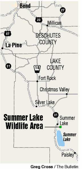
It was a good day to be flying out over the desert. No black ice this day. At a little over 100 miles southeast of Bend, the road to this river is far enough to make it interesting but not butt- and brain-numbingly so. I’d like to think Merle would agree.
The Ana River is as improbable as an espresso stand in Fort Rock.
You won’t see it until you’re right there, gazing down into the steep-sided slot canyon. Just seven miles long, the Ana flows from a series of underwater springs in Ana Reservoir, a 50-acre impoundment, built in the 1940s, that looks more like a big farm pond than a full-fledged lake. The spring water, an optimum 52 degrees the year round, creates a rich crucible of life along its short reach. The Ana makes a series of lazy turns and eventually flows into Summer Lake.
”It’s a little spring creek in the desert,” said Bill Tinniswood, a biologist with the Klamath office of the Oregon Department of Fish and Wildlife. ”It’s spring-fed. That makes it unique. You have year-long (insect) hatches. You can fish over rising fish every day of the year.”
Which goes a long way in explaining my high spirits this day, but you don’t have to be a dry-fly fisher to appreciate this oasis in the High Desert.
According to Tinniswood, the soil along the river is highly alkaline, and becomes more so the closer it gets to Summer Lake. Trout don’t do well in the lower reaches, but the irrepressible tui chub is said to survive down there.
”The Ana River is different than anything else around Oregon,” Tinniswood said.
One reason for the differences is that the Ana lies on the inside edge of the Great Basin, a 190,000-square-mile, bone-dry but cool expanse of high-elevation desert land. A major difference between the Great Basin and the desert just to the east of Bend is drainage. All of the rivers, streams, creeks and rivulets in our neck of the woods eventually find their way into the Pacific Ocean by way of the Deschutes and Columbia rivers. In contrast, the waters of the Great Basin are inland and isolated.
”The Great Basin is a series of drainages that are closed,” Tinniswood noted.
Historically (10,000 years ago), several basins – such as Warner, Goose Lake, Chewaucan and Summer Lake in the southeastern section of Oregon – were connected by a big body of water, Lake Chewaucan, he explained. Today, the basins within the (great) Basin are shut off from one another, with only the shared genetic characteristics of the redband trout and other fish offering a porthole to the past.
If you’re looking to see and photograph the Ana River, your best bet is to stay up top, where you can follow the canyon a ways and get a representative sampling of the river below, the desert at your feet and the nearby mountains. If the fishing (go ahead, just try to ignore those swirling trout below) or plain curiosity get the better of you, you’ll need to choose your descent (and subsequent ascent) carefully. With an abundance of recent rainfall, the slopes are a muddy mire in some places. Traction is at a premium.
We dropped down to the river several times, but did most of our downstream traveling up top.
The river flows roughly southeast to County Road 4-17, where it forms the northeast boundary of the Summer Lake Wildlife Area. Below the county road, the Ana flows inside the wildlife area where the water becomes increasingly alkaline.
If you’ve got the time and the appetite on the ride back home, stop in at the Cowboy Dinner Tree near the little town of Silver Lake for a cowboy cut 30-ounce top sirloin or whole chicken. They’ll make you cry uncle. The rustic restaurant is open Friday, Saturday and Sunday, 5 to 9 p.m. Call ahead (541-576-2426).
Whether you stop or not, it’s good traveling country.
Slow down. Plug in a CD. Enjoy the ride.
From Bend, drive south on U.S. Highway 97. Just south of La Pine, turn left on state Highway 31, which will take you south past Silver Lake. Make a left turn at the sign for Ana Reservoir a few miles north of Summer Lake. A right turn about a half-mile down the road takes you to the reservoir. You can also access the lower reaches of the Ana River by turning left off Highway 31 onto County Road 4-17 at the Summer Lake Rest area.
For more information on the Great Basin, try ”Basin and Range” by John McPhee.


Best of the Best of Bend 2025

-
eEdition

-

-
Go! eEdition