Burma Road
Published 5:00 am Friday, October 6, 2006
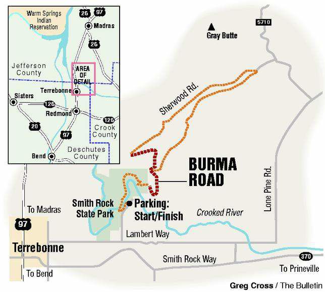
- Burma Road
The guy who lives across the street powers up the Burma Road on his mountain bike without stopping.
He makes me a little bit sick.
I rode the Burma Road. Which means I walked a little. OK, a lot.
But according to my highly personal and rigidly situational code of mountain biking honor, that was permissible as long as I kept moving and was pedaling when I crested the hill.
While the Burma Road conjures images of exotic Asian trade routes and bustling bazaars, this Burma Road is more straightforward than that.
Straight forward and up. The climb will be your all-consuming focus by the time you’re midway along the gravel grade that’s prominent on the side of the hill on the south side of Smith Rock State Park.
John Zilly calls it a ”first-gear Freddie” ascent in his mountain biking guide, ”Kissing the Trail.” My neighbor (who’s really a nice guy, even if he is in better shape than I am) calls it quite a hill.
They’re right. Cross-country runners and Nordic ski teams run intervals on the milelong hill. And bikers burn up it in Alpine gear for a substantial aerobic session.
But the Burma Road is more than just a training tool. It takes you up, over and into some fun riding past the saddle, it is accessible most of the year and it’s a hoot coming back down.
The ride (or hike) begins at the day-use parking area at Smith Rock State Park, where you abruptly descend a steep trail into the gorge of the Crooked River. You’ll cross a wooden bridge spanning the water and turn right onto a single-track path that parallels the east side of the river heading upstream.
After a quick mile-and-a-half, turn left and hike your bike up a steep, switchback trail that spits you out on the Burma Road several hundred yards upslope. Hop on your bike and ride until you can’t ride anymore.
The road makes a U-turn partway up the hill. Crane your neck to the right (but try not to fall over backward) on this final section and you’ll see big basalt faces looming overhead. To the left, it’d be a short plunge then a long roll down a very steep hill. Best to stay on the road here.
About a mile up, you’ll come to the saddle, a fine place to collect yourself and gaze out over Central Oregon and its defining peaks: Mount Jefferson, Mount Washington, the Three Sisters, Broken Top. From here, you have the option of scooting back down the Burma Road and wending back to the parking lot or forging ahead and exploring the back side of the park.
For a nice, scenic ride, take the road on the left and descend about a mile before making a right on Sherwood Road. You’ll ride through a gate, then come to a fork. Go left, then right and cross the dirt road. You can follow the Gray Butte Trail east and down into Skull Hollow and counterclockwise around the 5,108-foot peak.
Or you can hang a right at the road, cycle past the saddle and head gradually to the right to a fun section known as ”the traverse.” This will take you once again to the Burma Road and back the way you came.
More Local News


Best of the Best of Bend 2025

-
-
-