A trip to Proxy Falls
Published 5:00 am Thursday, July 22, 2010
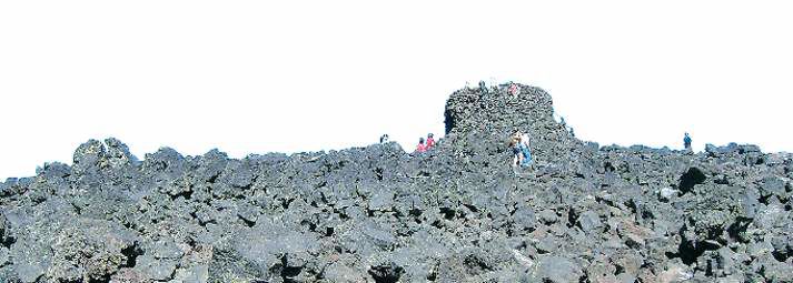
- Dee Wright Observatory is a castle made of lava rock.
The McKenzie Pass Highway is a perfect study in East versus West. I’m talking sides of the Cascades, naturally. On the east side, there’s impressive lava fields; on the west side, there’s greener-than-green mossy undergrowth. On the east, there’s jaw-dropping vistas of mountains. The west has eye-poppingly tall trees (turns out all that rain is good for something). It’s arid versus lush. Jagged versus soft.
But the beauty of this study is that there’s no need to choose sides. Along the McKenzie Highway, we can experience the best of both worlds within a few miles.
On Sunday, a friend and I decided to take a drive up the old highway, also known as state Highway 242, to take in a few scenic gems, including the rough lava-rock structure of Dee Wright Observatory and the intense, magical greenery of Proxy Falls.
The highway begins in Sisters and pops out near McKenzie Bridge on U.S. Highway 126. On a map, it might seem like an ideal shortcut to get from Central Oregon to Eugene (Google Maps offered it up as the best route between Bend and Eugene). But, oh my, no! This highway, which offers spectacular views, couldn’t be worse for getting from Point A to Point B, thanks to its narrow lanes, steep drop-offs, hairpin turns and switchbacks. The highway is open only seasonally, from about July through October.
After leaving Sisters, the road begins to climb into the mountains, and before long, curves around a large lava field. We crested the McKenzie Pass, which sits at more than 5,300 feet elevation. This road offers new perspectives on many of the mountains that we know so well. North and Middle Sister take center stage, and Mount Washington seems to change shapes depending on the angle from which you view it.
From the summit, we drove another 13 miles to Proxy Falls. The highway from the summit of the pass to the falls should keep drivers attentive; it descends at a serious clip, then begins a series of intense turns.
All around us, meanwhile, the landscape shifted rapidly. The lodgepole pines began to disappear, replaced by the much taller Douglas fir. I felt the temperature drop and more moisture in the air.
The pull-off for Proxy Falls is hard to miss. There’s a big sign and parking on either side of the highway. The trail can be quite busy during the day, especially on a summer weekend.
Hikers are encouraged to follow the loop trail in a counterclockwise direction, which helps reduce the trail traffic you pass during the hike. The path ascends from the road and traverses a rugged lava-rock trail for a while, followed by soft dirt and needle paths under giant trees. Soon we reached the first waterfall, Lower Proxy Falls. The path leads to a nice viewpoint far back from the falls
The waterfall isn’t overpowering like some. Instead, it’s tall and lovely, more of an intense trickling than a flood of water. Proxy Creek breaks up into multiple streams as it cascades over the edge and plummets 200 feet. The rocks and cliffs are covered with lush moss.
My friend and I decided to scramble down from the overview to get closer to the falls. While many visitors have made this trek, the path is not clear or well marked. We had to climb over and under numerous logs. After climbing down to creek level, we scaled up a rough, rocky path next to the waterfall. We climbed about halfway up to the top of the falls.
We basked in the mist that sprinkled our faces and grinned. My dad has referred to this area as “magical” and, seeing it up close, I understood why. I’ve never seen a waterfall so large in scale, but seemingly delicate. Close to the falls, the air seemed to sparkle. It felt something like a fairyland.
After we were done enjoying the glow of the falls, we made our way back down to the path. We seemed to have found a new route back to the trail, along a drainage. The area was quite lovely, filled with delicate wildflowers and moss. The path was also strewn with downed logs and infested with swarms of bugs. After about a quarter of a mile of rough going, we realized we had made a mistake. Eventually, we scrambled up the side of the bank and found our way back to the main path, which I would encourage people to stick to.
From there, we made our way to Upper Proxy Falls. The most dramatic aspect of this falls is how the water plunges into a lovely pool, which mysteriously has no clear outlet. Where does all the water from the roaring falls go? We again chose to scale up a rough path to get a closer look at the falls. While not quite as magical as the first falls, this one is also quite lovely.
We then made our way down and headed back around the loop to the car. In all, the trail is only about one-and-a-quarter miles. But all of the log traversing and scrambling made us feel as if we had walked triple that.
We got back in our car and weaved our way back up the highway, climbing out of the green back to the lava fields.
On our way back to town we stopped at Dee Wright Observatory, the classic viewpoint along the highway. The observatory is a castle erected out of lava that any passer-by couldn’t help but notice. It sits at the top of the pass and offers spectacular views of the surrounding mountains. While always packed with tourists, this is a place dear to my heart. I’ve been coming to the lava castle since I was a little girl. And there’s a purity to what the observatory offers. There’s no gift shop, no fee to pay, no turnstiles. You just climb to the top of the castle and enjoy the views. There are small peep holes in the lava walls with the name of each mountain or butte below it. For some reason, the novelty of this really gets me.
Having gotten our east-side fix in, we headed back down the pass and back to town. Every time I drive this highway, maybe once or twice a year, I like to think about the wagons and horses that used to make their way along the precarious route — not for leisure but out of necessity. It would have taken them days to make the transition from east to west. For us, it’s just a matter of a few gallons of gas and a desire to see the best of what our state has to offer, on both sides of the mountains.
If you go
What: Proxy Falls
Where: From Sisters, turn left onto state Highway 242 and drive for approximately 28 miles. Parking is on either side of the road. The trailhead is on the left.
Cost: $5 daily fee or Northwest Forest Pass required
Contact: www.fs.fed.us/r6/willamette/ or 541-822-3381


Best of the Best of Bend 2025

-
-
-