Hikers get historical amid ancient junipers at Oregon Badlands
Published 6:30 am Thursday, February 13, 2025
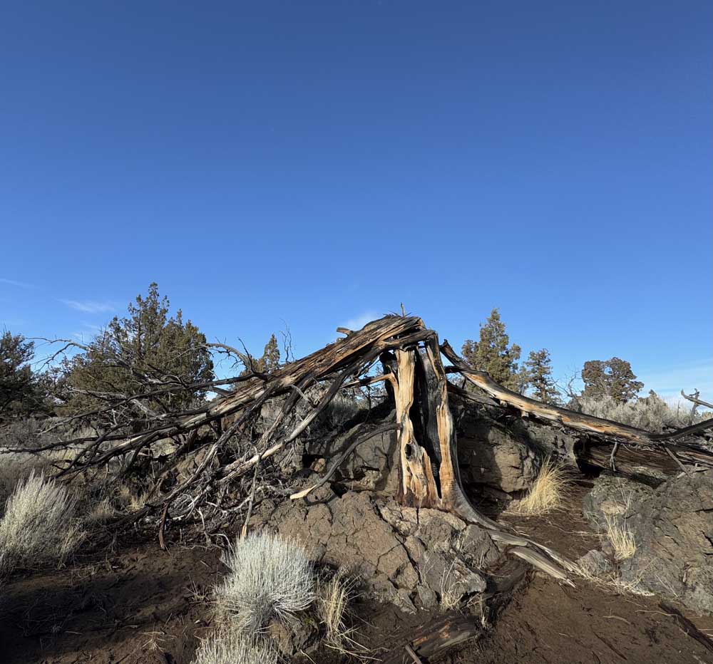
- A lightning-ravaged skeleton of a Western Juniper adds violent character to the Flatiron Rock Trail.
Among my favorite games to play with my kids is estimating the age of enormous trees we spot in the woods, and then bestowing a name upon the tree based on a historical figure that was born and/or lived at the same time.
For example: I see a towering ponderosa pine that is 3 feet in diameter, I call it a “George Washington tree” under the assumption that it is around 390 years old. (Don’t @ me, arborists and botanists; I’m not a professional ager of trees).
Trending
If I see a smaller ponderosa about 2 feet in diameter, I may call it a “William Henry Harrison Tree.” This may be just an obnoxious way for me to show off my obscure U.S. presidential knowledge. I never said this was my entire family’s favorite game.
Well, this game requires some additional historical knowledge when you are traversing the Oregon Badlands east of Bend, particularly on the Flatiron Rock and Ancient Juniper Trails. Some of the Western juniper behemoths in that area were seeded at the time of the Norman conquests. At least one tree located in the Oregon Badlands, probably near Horse Ridge, is estimated to exceed 1,500 years in age. (“Kids, look, a Marcus Aurelius tree!”)
Metolius Headwaters restore the soul
Ancient trees are but one of the many reasons I spent a recent winter morning on a 6.5-mile out-and-back hike with my 12-year-old son. In the latest in my continuing series of efforts to de-screen my tween’s weekends, I chose what I hoped to be a snow- and mud-free outdoor activity. In Central Oregon in February, that often requires heading east.
Trending
Alas, one of the more popular trails in the Oregon Badlands Wilderness Area (designated by Congress as such in 2009) is the Dry River Canyon Trail, but it’s closed annually to hikers as of Feb. 1 to protect endangered birds that nest in the area. The Flatiron Rock, Homestead and Ancient Juniper trails are each excellent silver medal options if you, like me, traveled 30 miles from home and forgot to research prior to leaving.
With two options at the trailhead, the Flatiron Rock Trail is a more direct (2.7 miles) route to Flatiron Rock. The Ancient Juniper Trail is more meandering, but worth the additional .7 miles to stare in awe at some of the expansive, Alfred the Great or Genghis Khan junipers that loom over the trail. Both trails will eventually merge as you proceed to Flatiron Rock, so you can’t go wrong.
The Western Juniper has received a bad rap of late, mainly because of the water it consumes, and the fact that there are so many more of these trees populating what was once a largely treeless prairie prior to European settlement of the area. White settlers and their grazing cattle cleared the way for more tree growth. The ancient trees, however, predate pioneers by centuries. To me, they deserve more awe than scorn.
They also aren’t the only elderly features of the wilderness. Lava rock upwellings, called tumuli, formed tens of thousands of years ago. Their formations add character to the landscape, particularly the closer you get to Flatiron Rock. They also provide bouldering side-quests for the young’uns (or the young at heart).
While the Badlands are less crowded than, say, the Deschutes River Trail, our Saturday morning met with several other hiking parties and a handful of other dogs (we included our young black lab on the trip). Trail use in the wilderness area is limited to hikers or equines only, so trail conflict is kept to a minimum. In other words, on some days you can walk for miles without seeing another soul.
After 1.9 miles, the Ancient Juniper Trail merges with the Flatiron Rock Trail, and we trekked another mile and a half northward toward Flatiron Rock. Lightning-scorched trees and lava-induced topography add a violent-past narrative to the quiet, peaceful hike. Some 7,000 years earlier, Mount Mazama erupted and spread the sandy soil that crunched beneath our feet.
Wild fauna sightings were rare, save for a few noisy ravens and a shy falcon that briefly patrolled its home sky before soaring out of sight. Snakes, deer, lizards and other animals call the Badlands home, but they are less apt to make themselves known in winter, and even less so along a popular human hiking trail.
Walking at a brisk pace, my son and I reached the merger of the Flatiron Rock and Castle trails in under an hour. To our left, a few dozen feet from the juncture, rose Flatiron Rock itself, begging us to climb aboard and survey the landscape. We obliged, and from the top, we could see snowcapped Pine Mountain and Paulina Butte to the east and northeast, and the Cascade foothills to the west. Heavy clouds from a gathering storm made it impossible to make out Mount Jefferson, the Three Sisters, and other Cascade peaks that would normally grace the horizon on a clear day.
At about 13 miles east of Bend, just north of U.S. Highway 20, the Flatiron Rock Trailhead is easy to spot. The gravel parking lot is well-marked by a sign on the highway and sits just meters from the road. The trailhead itself begins a hundred or so feet east of the parking lot.
I would recommend an early morning visit, as the chilly wind picked up considerably by the time we hit our last mile back to the parking lot. You may also want sunscreen, even in winter, to avoid aging like a Renaissance-era juniper.
Marketplace


Enter the $5,000 Sweepstakes

-
eEdition

-

-