Wildfires degrade air quality in parts of Central Oregon
Published 3:30 pm Wednesday, September 4, 2024
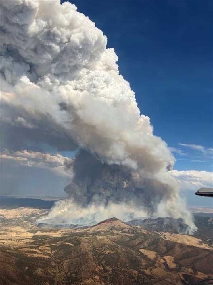
- Smoke rises Tuesday from the Shoe Fly Fire, which is burning northeast of Mitchell.
An air-quality alert has been issued for Crook and Deschutes counties due to new wildfire starts and increasing levels of smoke in Central Oregon.
The source of the smoke is wildfires in Oregon, California and Idaho, according to a the Oregon Department of Environmental Quality, which issued the alert on Tuesday. The alert is expected to be in place until at least Friday.
Alerts are also in place for Grant, Harney, Jackson, Klamath, Lake and Malheur counties.
When smoke levels are elevated the DEQ advises people to stay indoors, keep windows and doors closed and run air conditioning.
More Coverage
FAQ: Here’s how to manage air pollution when the AQI spikes
The air quality on Wednesday reached unhealthy levels in Prineville and Redmond. Air-quality levels at noon were 187 in Prineville, 163 in Redmond and 124 in Bend.
Joe Solomon, a meteorologist with the National Weather Service in Pendleton, said new fires in Central Oregon are contributing to the poor air quality. These include the Wiley Flat, Rail Ridge and Shoe Fly fires.
“Smoke from these fires (is) being pushed towards the Bend area by light easterly winds,” said Solomon. “These conditions are likely to last into the weekend and could get worse as there will be very little wind to scour out the smoke.”
Solomon said weather and smoke models indicate conditions could improve by early next week.
The following fires were burning Wednesday in or near Central Oregon:
• Wiley Flat Fire: Located 10 miles southwest of Post, off state Highway 380, this lightning-caused fire was zero percent contained and had burned 14,760 acres.
• Rail Ridge Fire: Located 32 miles south of Dayville, this fire had burned 62,433 acres and was zero percent contained.
• Copperfield Fire: Located 6 miles southeast of Chiloquin, this fire had burned 3,799 acres and was zero percent contained. The fire has destroyed eight homes and threatens over 200.
• Shoe Fly Fire: Located 7 miles northeast of Mitchell, this fire had burned 20,699 acres and was 2% contained.
• Red Fire: Located 5 miles west of Crescent Lake Junction this 851-acre fire was zero percent contained.
• Middle Fork Fire: Located in Crater Lake National Park, this fire had burned 5,286 acres and was 55% contained. Work on containing the fire has caused the north entrance of Crater Lake to be closed indefinitely.
• Diamond Complex: Located 8 miles west of Diamond Lake, this fire had burned 11,141 acres and was 79% contained.
• Crazy Creek Fire: Located 16 miles north of Paulina, partly in the Ochoco National Forest, this fire had burned 86,968 acres and was 95% contained.


Best of the Best of Bend 2025

-

-
-