Take a weekend drive up scenic Oregon Highway 27
Published 2:00 pm Wednesday, September 13, 2023
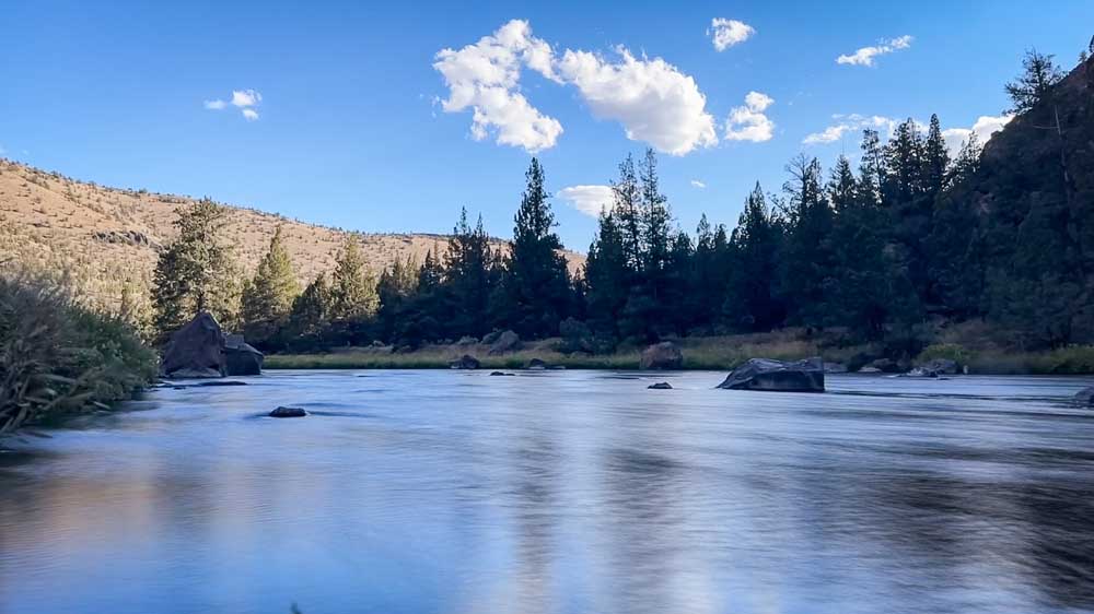
- The sun quickly dips behind the tall canyon walls along the Crooked River, cooling the river and temperatures early in the evening.
If you have done any amount of driving east on U.S. Highway 20 toward Brothers, you may have noticed a road sign pointing north to Prineville Reservoir down a seemingly common gravel road for this part of the state. It certainly doesn’t look like much, but make that turn and you’ll be pleased to find a stunning backroad that welcomes cars and bikes alike for a stunning trip down the Lower Crooked River Back Country Byway, officially known as Oregon Highway 27.
Long and winding road
Running about 44 miles from Prineville to Highway 20 between Millican and Brothers, with the last 18 (if you’re driving it from the northern end) being well-maintained, easily drivable, gravel surface, making it the only highway in the state that is not fully paved.
It doesn’t matter which end you start your journey on, and since there are no turns once you are on it, it is an easy road, perfect for when you just need to take a drive. But be prepared for spotty cell phone signals — if you get into trouble out there, you may have to hoof it to find some bars.
Starting in Prineville and working our way south, my sister, Heather, and I found ourselves stopping any chance we could along the first section of the road that follows the bends in the Crooked River. This Chimney Rock section of the river has been protected since 1988 under the National Wild and Scenic River System. Both of us were struck by the calming waters as they gently rushed passed us that early evening with cicadas chirping in the brushes nearby.
The imposing, high canyon walls throughout this section mean that the sun sets on the river early, making it an ideal spot for evening fishing. Anglers can fish here year-round and can expect to catch trout in its waters including red bands. They may also encounter bull trout tugging on the end of the line, but they must be released if caught here along with any trout measuring over 20 inches.
Rogue River Gorge Viewpoint is a must-stop roadside attraction
There are six campgrounds along the route and one designated trail that leads to Chimney Rock, a craggy piece of basalt that stands like a chimney high above the Crooked River.
These high walls are what remains from epic eruptions, leaving behind ruddy brown-colored basalts, grayish ash and sedimentary rock formations. The river helped cut through these formations leaving behind stunning geologic remnants around every bend.
The imposing rock formations are broken up by rich, verdant riparian areas around the water’s edge and juniper-dotted hills.
The most fascinating rock formations come just before the road climbs to Bowman Dam, with the road hugging the eroded rock faces tightly along its twistiest section. The river and the road then diverge as you make the journey up to Prineville Reservoir.
Water, water everywhere
I hadn’t had the chance to make it to the reservoir yet this summer, and after years of low water levels and the Powder House Cove Boat Ramp’s consistent closure through most of it, I wasn’t prepared to see the water level as high as it still is. According to the Bureau of Reclamation website, as of Sunday, Prineville Reservoir is currently 66% full, but my heart swelled to see the waterline high enough that the boat dock there is still in use.
Since Powder House Cove Boat Ramp is about the halfway point, it’s a good spot to stretch your legs, and besides checking out the lake, there is a very short walkway up to the historic powder house from which the ramp gets its name.
From here, the route along the highway dries out considerably, and instead of the wide Crooked River, it follows the trickle that is what is left of Bear Creek after the summer.
Gravel and gold
Through juniper stands and private farms, the road soon turns to gravel and passes through open range land with resident ranchers posting several make-shift signs alerting travelers to that fact.
Peak-a-boo views from the dusty road occasionally bring wonderfully scenic shots of the buttes and hills of the area, and if you travel in the evening, they are illuminated by the slowly setting sun.
With few cars passing us by last Saturday evening, our quiet ride became even quieter save for the rumble of the road.
These hills, again, are a remarkable sight that suddenly gives way to the flat sagebrush sea that borders U.S. Highway 20 for miles. And in the setting sun, with long shadows being cast over the remaining bumps in the landscape, the Cascades hazy in the west and the bitterbrush glowing in the sun, we met up with that long, lonely highway and headed back to Bend, buoyed by a classic weekend drive through a section of Central Oregon rarely traveled.


Best of the Best of Bend 2025

-
eEdition

-

-
Go! eEdition