Tundra-like Fort Rock yields an unforgettable trip
Published 3:55 am Friday, November 25, 2022
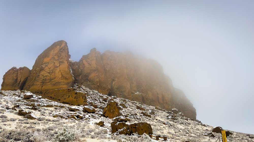
- Fort Rock as a fog bank rolls in, obscuring the geologic feature on Nov. 13.
FORT ROCK — Fort Rock was missing.
A peasouper of fog enveloped the famous rock, obscuring it completely from view as my sister and I drove into the tiny nearby town that shares its name about 37 miles southeast of La Pine earlier this month. I had never seen anything like it.
With an additional four to five inches of snow on the ground and everything covered in a fantastic frost, we remarked that we couldn’t remember a time visiting one of our favorite volcanic tuff rings in such deep snow.
When the white stuff begins to fly in the mountains and creeps down to Bend, my go-to place to explore has been to point my trusty four-wheel drive crossover east to the Fort Rock Basin, where the conditions are dryer and considerably less changeable.
There is something about this area I simply cannot get enough of. Perhaps it’s the sparsity, the wide-open skies or the fascinating geologic and human history of the area. Whatever keeps pulling me there, on a recent trip to try and find my way to Derrick Cave, I found my plans, preconceived notions and Jeep put to the test.
Best laid plans
It’s been over 25 years since I visited Derrick Cave, a short lava tube about 23 miles north of Fort Rock, and roamed around it and the adjacent Devil’s Garden lava flow. But back then, the trip was taken in the back seat of my parent’s Bronco. I remember the skylights of the cave and the black lava rock capturing my childhood imagination as our drives often did. Though we didn’t plan on entering the cave this trip, as bats may be hibernating inside, it still seemed like a fun Sunday drive — like the ones we had done as kids.
Armed with both downloaded maps (there is spotty cell service out here) and my sister’s trusty Oregon Gazetteer, we figured our years of experience driving up and down dirt roads throughout the state would make this voyage to the cave easier than online commenters made it sound.
We were wrong.
Thanks to that thick fog, forest service roads not ideally marked, private property lines blocking alternate routes and the deepening snow with unknown conditions underneath, after about 15 miles and a dwindling gas tank, we decided to not become a statistic and called it quits on making it to the cave.
But this 20-mile side trip on forest roads near Cabin Lake yielded fantastic forest vistas, a few mule deer stoically watching us as we slowly rolled by through the snow, as well as finding an abandoned building that may have housed an old well or pump house.
Back to the rock
Feeling a little defeated, we figured we’d at least head to the breathtaking Fort Rock State Natural Area for a short hike.
One of our favorite walks, it offers an up-close look at some truly great examples of volcanism in this area of the state.
As we pulled into the parking area the fog was starting to lift. The orange-brown walls eroded by the ancient lake that once lapped its face were covered in snow, creating a texture that looked closer to a molasses crinkle cookie than a geologic feature.
The trail at Fort Rock is short and relatively easy, with only slight elevation gain at the start. The loop is just over a mile and takes you counterclockwise into the bowl of this magnificent formation. In it, you’ll find sagebrush and other desert shrubs and grasses taking root in sandy soil among the basalt that rose from this lakebed 50,000 to 100,000 years ago.
Fort Rock lies within the Fort Rock Basin, once home to a lake. According to an Oregon State University website, the basin is home to nearly 40 volcanic maars (like nearby Hole-in-the-Ground), tuff rings (like Fort Rock) and tuff cones, most of which are incredibly eroded.
The lake met with much volcanic activity during and after its lifespan; hence the lava fields and other features that dot the basin.
When the lake’s waters still covered the basin, Fort Rock was formed as a ring-like crater as magma met the groundwater. After the rock cooled, and thanks to the lake’s southeasterly waves crashing against it, eventually that side of the ring eroded away, leaving the opening seen today.
Walking along the main trail, you’re struck by the 200-foot walls that tower above and are dotted with holes from wind erosion, serving as sometime-home to falcons and other desert creatures you can spot if you’re patient.
Humans, too, have called this area home for thousands of years. Just to the west of the rock is Fort Rock Cave, where archeologists found sagebrush sandals that belonged to original inhabitants 9,000 years ago.
Glitter in the air
As my sister and I walked up into the basket-like Fort Rock, a trail we’ve traversed more times than we can count, we looked out over the valley that looked more like tundra than sagebrush desert.
Never in the 30-something years we’ve come out here had we seen the kind of weather we did that day. As the sun warmed us slightly from the 10-degree chill, and the fog banks slowly crept over the town of Fort Rock and moved their way toward us, the air filled with ice crystals gently dancing to earth.
Armed with just our normal hiking shoes and not-thick-enough socks, we trudged about halfway along the trail in the few inches of snow that lay beneath our feet, spying the occasional cottontail rabbit or robin hunkering down and preparing for the next wave of frigid fog. We watched a juvenile bald eagle soar along the rim, and after a change in the wind, we cut the hike short, trying to get back to the car before the next fog bank rolled in.
As we reached the picnic area below, Fort Rock was again enveloped in that soupy fog that had followed us all morning, giving an eerie vibe to the whole place. It dampened what little sounds there were, adding to the spooky feeling.
It didn’t matter that we never made it to our initial destination. Seeing one of my favorite places in Oregon take on an otherworldly look granted me new perspective. The endpoint isn’t the best part about exploring Oregon. The best part is experiencing our home in new lights.
So don’t be afraid to turn back or make a new destination. There’s always time to stop and admire something along the way.
Getting there: From La Pine, drive 2 miles south and turn left onto the Fremont Highway/OR-31 and drive southeast for 29 miles. Turn left onto Country Road 5-10 toward Fort Rock and go 6.4 miles into the town of Fort Rock. Turn left onto Cabin Lake Road (at the small State Park sign) then drive for 1/10th of a mile and turn left again. Fort Rock State Natural Area is on the right after the cemetery.


Best of the Best of Bend 2025

-
eEdition

-

-