Bonus pick of the week: Fort Rock
Published 12:00 am Friday, August 6, 2021
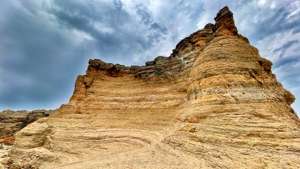
- A rock in the middle of Fort Rock reveals eroded wavelike layers.
Somehow I knew Sunday was going to be a great day to go east.
With temperatures rarely cooling down this summer, I figured that my trips to the Oregon Outback would be put on hold for a while. My love of the area and the landscape wasn’t as strong as my will to stay out of the heat. But this past Sunday, with storms brewing across Central Oregon, I took a chance and stopped off at my favorite rock in the middle of the desert : Fort Rock. It did not disappoint.
Trending
The storm clouds swirled over the volcanic tuff ring, highlighting the colors within the rock, the wave cuts, the wind-eroded potholes and the peregrine falcons soaring above. The wind from the Fort Rock Valley below blew strong through the southern opening in the u-shaped basket. It’s understandable why many homesteaders left their claims behind.
Fort Rock State Natural Area is open for day use only and has a short trail through the innards of the rock formation with a few social trail scrambles to the rim. Right now the southeastern corner of the rock is closed to climbing to protect those nesting peregrines that always come out to check what the hikers are doing in their yard.
The rock was formed when an eruption from under the surface of the ancient lake bed that covered the valley cooled then was eroded by said lake water over the next 50,000 to 100,000 years. Now it stands at about 200 feet above the valley floor and is imposingly large across the otherwise flat terrain.
With the sky trying to drizzle on me, I made my stop as quick as I could, admiring the changing light as the sun burst briefly through the clouds before quickly returning behind the gray masses above.
With the weather cooling slightly this week, make the trip southeast to this stunning formation and enjoy the geologic and scenic splendor of northern Lake County.
Getting there: Travel south on U.S. Highway 97 for 31 miles then turn left onto state Highway 31. Drive southeast for 29 miles then turn left onto County Road 5-10 towards the town of Fort Rock. Travel 6.4 miles east and, after the Fort Rock General Store and gas station, turn left onto Cabin Lake Road . Drive north for a mile then turn left onto County Road 5-11A for a half mile, and the Fort Rock State Natural Area parking and day use area will be on the right.
Trending
Marketplace


-
eEdition

-

-