Central Oregon Avalanche Center helping keep backcountry enthusiasts safe
Published 5:00 am Friday, March 5, 2021
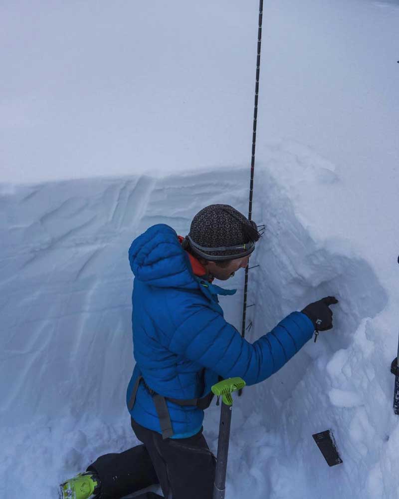
- Central Oregon Avalanche Center forecaster Gabe Coler examines the layers of snow after digging a pit in the Central Oregon backcountry.
It has been a dangerous, deadly winter from avalanches across the West.
As of Thursday, 33 backcountry users had died in avalanches in 2021, according to the National Avalanche Center. Most of those deaths occurred in Utah, Colorado, Montana and Wyoming, where snowpack has been weak, said Kevin Grove, board member of the Central Oregon Avalanche Center.
Trending
Oregon has reported no avalanche deaths this winter, but there have been a fair number of close calls right here in the Central Oregon Cascades, according to Grove.
“And every time we hear of those, that’s probably just a small fraction,” Grove said. “Three weeks ago, when we had 3 to 4 feet of snow over three days, that’s when we were seeing a lot of the near misses. We’re always monitoring layers down in the snowpack and paying attention to current storms, and what the winds are doing.”
The Central Oregon Avalanche Center , or COAC, this winter for the first time is providing an avalanche danger rating four days per week (Fridays through Mondays) for the Central Oregon Cascade Range on its website coavalanche.org.
“In general, the last 10 years, the average fatality numbers have remained constant,” Grove said. “Which is really remarkable considering the exponential growth of backcountry users. As educators and forecasters, we like to think that all the work that we do is contributing to that. We like to think we’re helping keep Central Oregon users safe in the backcountry.”
COAC uses the North American Danger Scale, which runs from 1 to 5: 1, low; 2, moderate; 3, considerable; 4, high; 5, extreme. The center pays four professionals (two forecasters and two observers) to analyze and report the conditions at select areas in the Central Oregon backcountry. Skiers, snowboarders, snowmobilers and climbers can then use that information to make decisions about if, when or where to go.
COAC forecaster Gabe Coler has been hard at work in the Central Oregon backcountry assessing the snowpack and providing avalanche forecasts this winter.
Trending
“Sometimes, it’s so dangerous that no one should be skiing on steep slopes,” Coler said. “But the goal of the avalanche forecast is to point people in the direction of which slopes are safe, and which ones will be dangerous. Wind slabs are the most prevalent avalanches here, which is when wind moves and compacts a lot of snow and can create a hard slab.”
The forecasting zone for COAC runs from Mount Bachelor north to Tam McArthur Rim, the Three Sisters and Santiam Pass. Grove said the center would like to eventually offer reports for the Mount Jefferson and Three Fingered Jack areas, as well as Paulina Peak, located east of La Pine in the Newberry National Volcanic Monument.
The most popular backcountry spot for skiers, snowboarders and snowmobilers in Central Oregon include Tumalo Mountain, Broken Top, Ball Butte and Tam McArthur Rim. All of those locations have snow slopes that are prone to sliding, according to Zoe Roy, development director for COAC.
“Those are well-skied spots, and if a person sees ski tracks on a slope, it’s imperative that they still make their own assessment and judgment of the avalanche danger,” Roy said. “Many of our Central Oregon storms come in with heavy snow and wind, making for prime avalanche conditions. And those conditions don’t necessarily dissipate the moment the storm ends — it can take a few days for the snow to settle.”
When Coler goes into the backcountry as a forecaster, he analyzes the snowpack, looking for weakness in the layers and how the wind has redistributed the snow that could lead to unstable slabs. He combines that information with weather forecasts to offer an avalanche forecast and a danger rating for the next day on the website, along with other descriptions of the avalanche problem such as the type, likelihood and size.
“There’s lots of new users in the backcountry, too,” Coler said. “More people have more free time, and more people are getting into the backcountry. It’s especially a good service for them. It’s about how they interpret an avalanche forecast and go touring in an appropriate place.”
Grove, an engineering professor at Central Oregon Community College, said the goal of COAC has always been to become a Type 1 center, like the Northwest Avalanche Center — which serves the Washington Cascades, the Olympic Mountains and Mount Hood — and offer a forecast seven days per week.
“It’s just a fact of time and money right now,” Grove said. “But that’s our goal is to one day offer a forecast seven days a week. Overall, the community has been very complimentary and, I think, values the resource. We’re seeing more members this year, and we’re seeing more membership dollars.”
Roy said that COAC has had a 37% increase in members and 41% increase in social media following this winter.
“The information on the forecast platform is easier to digest and more user friendly due to the use of diagrams, photos and colors along with short summaries to describe the current avalanche hazard,” Roy said.
She added that every backcountry skier, snowboarder, snowmobiler and climber should check coavalanche.org before venturing out into the backcountry of the Central Oregon Cascades.
“However, it’s important to remember to use your senses once you’re out in the backcountry and pay attention to the snow, weather and terrain,” Roy said. “No matter what the avalanche forecast says, even if it says low danger, there is always still danger.”
Marketplace


Enter the $5,000 Sweepstakes

-
eEdition

-

-