Return to Smith Rock
Published 2:00 am Friday, December 11, 2020
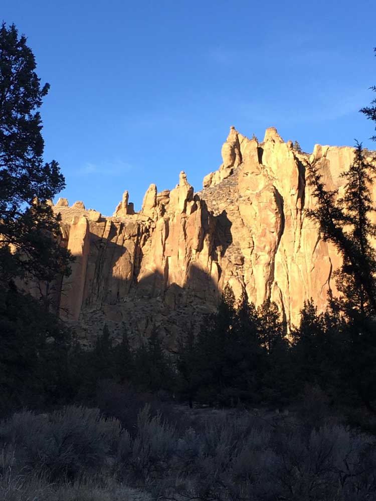
- The views are always incredible at Smith Rock, but the low-hanging sun of winter seems to heighten the drama, the long shadows revealing more crevices and interesting features in the rocks.
I’m going to wager that the most commonly heard dad joke at Smith Rock State Park is some variation of “Now I know why they call it Misery Ridge.”
I know this because I am a dad, and I semi-ironically made a remark along those lines a couple of weeks ago, when I headed to Smith Rock with my wife and our daughter Lilly.
Trending
In the interim since I’d last visited, I’d forgotten just how beautiful a view of the Cascades Range to the west, and the sprawling grasslands between, this place affords. But make no mistake: Unless you do squats the way I eat ice cream, which is often, or you’re into climbing massive amounts of stairs, getting up to the 3,360-foot summit is a little bit of work. “Misery” might be a bit of a stretch, but then again, maybe not.
In the spring of 2013, which I believe is when I made my last visit, I wrote in The Bulletin, “After I moved here 11 years ago, it was a semiregular destination, but with so many outdoor options around, I’d unwittingly — and unwisely — put Smith Rock in the ‘been there, done that’ category.”
And then I stayed away from Smith Rock another seven and a half years after THAT, which given our pleasant sojourn two weekends back, I can say was 100% a mistake on my part.
There’s no one reason that I stayed away so long, but the fact that I am generally repelled by big crowds goes part of the way. And I’m certain I’ve only become more irascible and misanthropic this year given our pandemic plight. To be sure, Smith Rock State Park was popular when I was going there more regularly, but if memory serves, we mostly saw families and the occasional climber or two back in those days.
As The Bulletin’s Kyle Spurr reported in 2017, Smith Rock State Park’s visitation numbers shot up 35 % between 2012 and 2016. The high volume of users was confirmed on the Saturday we chose to go. We arrived during the late morning and had to sit a few minutes in the car, idling at the foot of the parking lot hoping one of the approaching pedestrians might be leaving so we could have a parking spot … any parking spot … come on, parking spot.
As we made our way down The Chute, a steep descent to the river level, we saw a lot of other hikers ahead of us, as well as climbers here and there along the rock wall ahead. Before long we were making our way up the Misery Ridge Trail. If you’re inclined (pun intended) to use a walking stick on steep slopes, this would be the place for it.
Trending
Despite the crowds, almost everyone was wearing masks or pulled them up as they neared others, slow-moving parties making room for others to pass.
We took a break for snacks once we reached the summit, warming ourselves in the sun and taking in the views, including the river below us. And then we continued on toward Monkey Face, which indeed resembles a monkey’s face. Kudos to the brave souls climbing the primate-looking pillar.
Our plan had been to make a loop out of the hike, a distance of about 3.8 miles total. Aside from climbers making their way up routes far above our heads and skill levels, the crowds thinned out tremendously after we passed Monkey Face. After we made our way down the long descent of the Mesa Verde Trail, we took the River Trail, an easy, relatively flat portion affording perhaps the best views of our entire hike.
Getting there: In Terrebonne, head east on Smith Rock Way, turning left at Lambert Road. Follow signs to Smith Rock State Park.
Cost: $5
More information: smithrock.com, stateparks.oregon.gov or 800-551-6949
Marketplace


Enter the $5,000 Sweepstakes

-
eEdition

-

-