Conditions report for areas north of Bend
Published 12:00 am Friday, October 16, 2020
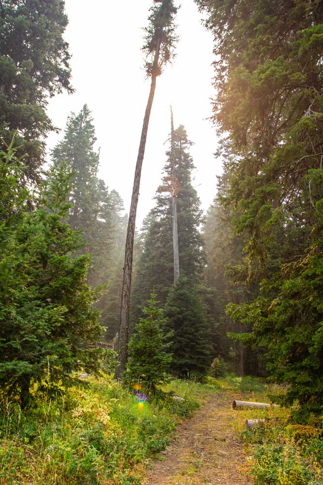
- The Independent Mine Trail in the Ochoco National Forest is surrounded by larch and fir trees.
There’s still time to head out to the mountains and forests in northern Deschutes and Crook counties. But with consistently cooler temperatures on the way, the window of opportunity is closing. Plus, now is a great time to catch the fall colors along some of the rivers and mountain creeks.
While many campgrounds are closed for the season, trailheads have reopened with the further containment of the Lionshead Fire near Mount Jefferson. As of Thursday, the entirety of the Sisters Ranger District has reopened.
For a full list of conditions updated regularly, please visit centraloregonexplore.com
Hiking and Day Use Sites
Deschutes National Forest
Black Butte Trailhead: Open
Black Crater Trailhead: Open
Buttes Loop Trailhead: Open
Canyon Creek Trailhead: Open
Chush Falls: Open
Cold Springs Day Use: Open
Head of Jack Creek Trailhead: Open
Head of the Metolius: Open
Jack Lake Trailhead: Open
Lake Creek Trail: Closed
Lava Camp Lake Trailhead: Deadfall reported in areas
Lower Black Butte Trailhead: Open
Lower Bridge Day Use: Open
Lower Canyon Creek (West Metolius Trailhead): Open
Metolius-Windigo: Closed from Forest Road 380 to Bear Valley Trailhead due to Lionshead Fire
Millican Trail Trailhead: Open; clear as far as Trout Creek Tie with heavy deadfall reported beyond
Park Meadow: Open
Pole Creek Trailhead: Open
Round Lake Trailhead: Open
Scott Pass Trailhead: Open
Scout Lake Day Use: Open
Sisters Cow Camp: Open
Sisters Tie Trailhead: Open
Tam McArthur Rim Trailhead: Open
Whychus Creek Overlook Trailhead: Trailhead is temporarily closed for maintenance but an alternative route is in place.
Whychus Portal (Lower Whychus Trailhead): Open
Ochoco National Forest
Alder Springs Trailhead: Open
Baneberry Trailhead: Open
Barnhouse Trailhead: Open
Black Canyon East (Formerly South Fork) Trailhead: Open
Black Canyon West (Formerly Dusty Camp) Trailhead: Open
Boeing Field Trailhead: Open
Coffeepot Trailhead: Open
Cottonwood Trailhead: Open
Cougar East Trailhead: Open
Cougar West Trailhead: Open
Cyrus Trailhead: Open
Fry Trailhead: Open
Giddy-Up Go Trailhead: Open
Gray Butte Trailhead: Open
Green Mountain North Trailhead: Open
Green Mountain South Trailhead: Open
Henderson Flat OHV Trail System: Open
Henderson Flat Staging Area: Open
Keeton Trailhead: Open
Kelsey Trailhead: Open
Line Butte East (Formerly Fawn Creek) Trailhead: Open
Line Butte West Trailhead: Open
Lookout Mountain Lower Trailhead: Open
Lookout Mountain Upper Trailhead: Open
Mascall Corral (Formerly Apple West) Trailhead: Open
Mother Lode Mine Trailhead: Open
Payten Trailhead: Open
Potlid North Trailhead: Open
Potlid South Trailhead: Open
Rim (Formerly Apple Middle) Trailhead: Open
Rimrock Springs Trailhead: Open
Rock Creek Trailhead: Open
Round Mountain North Trailhead: Open
Round Mountain South Trailhead: Open
Scales Corral Trailhead: Open
Scotty Creek Trailhead: Open
Skull Hollow Trailhead: Open
South Prong Trailhead: Open
Steins Pillar Trailhead: Open
Tam-A-Lau Trailhead: Open
Trail Crossing Corrals Trailhead: Open
Twin Pillars North Trailhead: Open
Twin Pillars South Trailhead: Open
Walton Lake Trailhead: Open
Wildcat North Trailhead: Open
Wildcat South Trailhead: Open
Bureau of Land Management
North Fork: Open
Redmond Caves Recreation Site: Open
Scout Camp Trail: Open
Steelhead Falls Trail: Open
Trout Creek Trail: Open; please respect private lands bordering trail
Oregon State Parks
Cline Falls State Scenic Viewpoint: Open; limited services; restrooms open 10 a.m.-7 p.m. daily and may close without notice; maintain social distancing and wear a mask
Cove Palisades State Park: Open; reduced services; showers open with limited hours; cabins and group picnic areas are reservation only; group tent sites are closed. No campfires
Peter Skene Ogden State Scenic Viewpoint: Open
Smith Rock State Park: Open — limited services; no camping.
Tumalo State Park: Open; reduced services; showers open with reduced hours; yurts and group facilities are closed
Camping
Deschutes National Forest
Allen Springs Campground: Open
Camp Sherman Campground: Open
Cold Springs Campground: Open; no water
Graham Corral Horse Camp: Open
Indian Ford Campground: Open; no water
Lava Camp Lake Campground: Open
Link Creek Campground: Open
Lower Bridge Campground: Open
Pine Rest Campground: Open
Sisters Cow Camp Horse Camp: Open; no campfires
Ochoco National Forest and Crooked River National Grassland
Allen Creek Horse Camp: Open; no campfires
Barnhouse Campground: Open; no campfires
Big Spring Campground: Open; no campfires
Biggs Springs Campground: Open; no campfires
Cottonwood Campground: Open; no campfires
Cottonwood Pit Campground: Open; no campfires
Cyrus Horse Camp: Open; no campfires
Deep Creek Campground: Open
Dry Creek Horse Camp: Open; no campfires
Haystack Reservoir Campground and Day Use Area: Open
Haystack Reservoir Group Site: Open; managed by Crook County
Haystack West Shore Campground and Day Use Area: Open
Mud Springs Horse Camp: Open; no campfires
Ochoco Divide Campground: Open
Ochoco Forest Campground: Open
Ochoco Forest Camp Group Pavillion: Open
Skull Hollow Campground: Open
Sugar Creek Campground and Day Use Area: Open
Walton Lake Campground: Open
Walton Lake Group Campsites: Open
Whistler Campground: Open; no campfires
White Rock Campground: Open; no campfires
Wildcat Campground and Day Use Area: Open
Wildwood Campground: Open; no campfires
Wolf Creek Campground: Open
Wolf Creek Industrial Campground: Open; no campfires
BLM — Prineville District
Barr Road North Staging Area: Open; no campfires
Buckhorn Staging Area: Open; no campfires
Macks Canyon Recreation Site: Open; no campfires
Steelhead Falls: Open; no potable water; no campfires
Cycling
Prineville and Ochoco trails
Cougar Creek, Independent Mine, Lookout Mountain: Riding well; deadfall reported
All other trails riding well
Sisters trails
Green Ridge: Closed due to fire activity
Lake Creek, Metolius-Windigo (Black Butte) and Suttle Lake Loop: Riding well; deadfall reported
Metolius-Windigo (99 Lower): Sandy and loose; deadfall reported
Metolius-Windigo (99 Upper): Sandy and loose
All other trails riding well
Maston complex
All trails reporting sandy and loose conditions
Redmond trails
All trails riding well
Fishing
Updated at 8 a.m. Oct. 15
Lower Deschutes (Pelton Dam to Columbia River): 4,540 cfs; rainbow trout, steelhead; White River has been making water clarity in the lower Deschutes less than ideal, though it should clear up as Mt. Hood temperatures cool for the season
Middle Deschutes (Benham Falls to Lake Billy Chinook): 3,910 cfs; brown trout, rainbow trout; look for trout in deeper, well-aerated water and shady spots along the bank; caddis patterns and large stonefly nymphs can catch fish; fishing continues to be good.
Crooked River (below Opal Springs): 1,323 cfs; rainbow trout and mountain whitefish; water temperatures and flow remain good and there are good populations of both trout and whitefish; no bait allowed
Metolius River: 1,270 cfs; bull trout, rainbow trout; fly fishing only upstream of Bridge 99, artificial lures and flies permitted below; catch and release only; public access to Wizard Falls Hatchery remains closed
McKenzie River (at Clear Lake): 149 cfs
McKenzie River (near Belknap Springs): 581 cfs; rainbow and coastal cutthroat trout; current hatches — blue winged olive, midge, sculpin; fishing activity has stopped due to the Holiday Farm Fire, access remains limited.
Ochoco Reservoir: 14% full; rainbow trout, black crappie, smallmouth bass; bass population is abundant, crappie aren’t as abundant. Low water level has made the boat ramp unusable for boats on trailers.
Haystack Reservoir: 95% full; rainbow and brown trout, kokanee, largemouth bass, black crappie, bluegill and bullhead catfish; boat access unavailable until reservoir refills early this month
Lake Billy Chinook: Algae bloom; fishing is good for kokanee in the upper Metolius Arm as the fish begin to spawn
Fire danger is currently listed as Moderate in both the Deschutes National Forest and Ochoco National Forest.
As of Oct. 14, the Industrial Fire Precaution Level as been lowered to a Level 1 for the Deschutes and Ochoco national forests and the Prineville District — Bureau of Land Management.
As of July 22, Deschutes River access is closed due to safety concerns and to prevent further erosion to the river bank. The access point will be closed until further notice. For more information visit bendparksandrec.org


Best of the Best of Bend 2025

-
-
-