Climbing South Sister
Published 2:30 am Friday, September 4, 2020
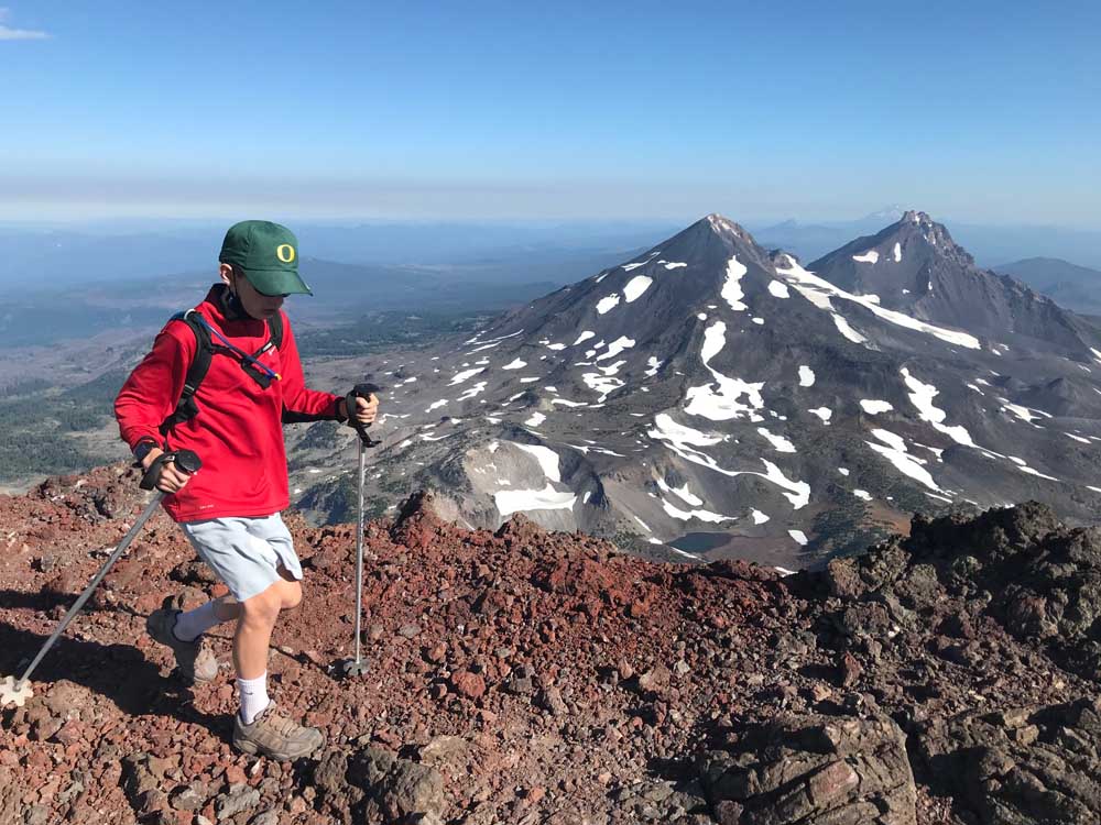
- Bend’s Mason Morical, 12, walks across the summit of South Sister on Aug. 15. In the background, Middle Sister, left, and North Sister, right, can be seen from the summit.
The alarm went off at 4 a.m.
It was an early wake-up call, but with a particular peak goal in mind, it was easy to get up and going.
My 12-year-old son Mason and I have talked about climbing South Sister for several years, and this would be the day. Knowing that it would also be the goal of hundreds of others on a clear, hot August Saturday, I wanted to get an early start.
Traffic was light on Century Drive and Cascade Lakes Highway, but as we drove past Sparks Lake in the dark, I noticed two points of light high on the slopes of South Sister. Some other eager climbers had made an even earlier start than us.
After a 30-minute drive from Bend, we parked just off Cascade Lakes Highway along Devils Lake, then crossed the highway to the Devils Lake Trailhead.
(Next year, the South Sister Climbers’ Trail will be one of several limited-entry trails in the Three Sisters Wilderness, and hikers will need to purchase a wilderness permit in advance of their trip.)
It had been 13 years since I reached the top of 10,358-foot South Sister, and this would be my third summit of the peak and Mason’s first. The third-tallest mountain in Oregon is a popular climb because hikers can essentially walk to the summit without the use of ropes, crampons or other technical gear.
While the trail to the top involves no technical climbing, it is tremendously steep and challenging. From its starting point near Devils Lake off Cascade Lakes Highway west of Bend, the trail gains nearly 5,000 feet in elevation over the six miles to the summit.
We started from Devils Lake at about 5:30 a.m., about 45 minutes before sunrise. But we only needed our headlamps for maybe 20 minutes or so, as the predawn light illuminated the surrounding forest. We hiked in comfortable shade for about two hours before the sun finally came up over Broken Top.
The trail from Devils Lake took us seemingly straight up through a thick evergreen forest. That early in the morning, we had the trail mostly to ourselves, though we passed a few groups along the way.
After nearly 2 tough miles of steep climbing, we came out of the trees to a sprawling, desert-like plateau. South Sister dominated the horizon in front of us, and near its summit we could see the thin line through the red scree that marked the rugged trail to the top. Broken Top was just off to the west and just below us was sparkling blue Moraine Lake.
The trail stayed flat for a mile or so, then steepened drastically. We climbed our way up loose rock, using ski poles for added leverage. (Ski poles or trekking poles are highly recommended for this hike and prove especially useful for keeping one’s balance on the steep slog back down the mountain.)
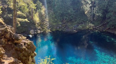
Another 1.2 miles and we reached the first false summit, where a small blue-green lake sits at the base of Lewis Glacier. Many climbers stopped there for lunch, but we pushed on, our feet slipping and sliding up the loose red cinder.
After another false summit, we made our way another half mile across a vast snowfield to the actual summit a little before 9 a.m.
The view was as dramatic as I remembered it. Middle Sister and North Sister dominated the skyline to the north, with other mountains of the Cascade Range — Mount Washington, Mount Jefferson and even distant Mount Hood — in view. The dazzling array of blue sky, rugged, snow-covered peaks, and pristine alpine lakes made the climb well worth the effort.
Much of South Sister’s summit is covered by a large, snowy crater, in the middle of which sits sparkling blue Teardrop Pool, recognized as the state’s highest lake.
On the summit, about a dozen or so triumphant climbers took photos and videos, and soaked in a view exclusive to this unique vantage point high in the Central Oregon Cascades.
The temperature would reach nearly 100 degrees in Bend on that day, but atop South Sister, the wind was strong — and we were so cold — that we decided to head down after half an hour at the top.
We walked back over the snowfield on our way back down the steep trail, sliding and walking down the loose rock in short steps, using our ski poles for support.
Maintaining balance was sometimes a struggle because of the steepness of the trail and the loose rock. Adding to the challenge were hundreds of climbers who were ascending at that time of day while we descended. We pulled up our face masks when social distancing was impossible among the throng of hikers.
On all three of my South Sister trips, I have found that going down is more challenging than going up.
By the time we reached the plateau near Moraine Lake, we saw almost no more hikers, as few would want to make the hike in the hot temperatures of the afternoon.
When we finally reached the trailhead at Devils Lake by 12:30 p.m., our journey complete, we soaked our feet in the ice-cold water of Tyee Creek.
More Explore


Best of the Best of Bend 2025

-
-
-