Is the Four Corners National Monument in the right spot?
Published 12:00 am Thursday, May 17, 2018
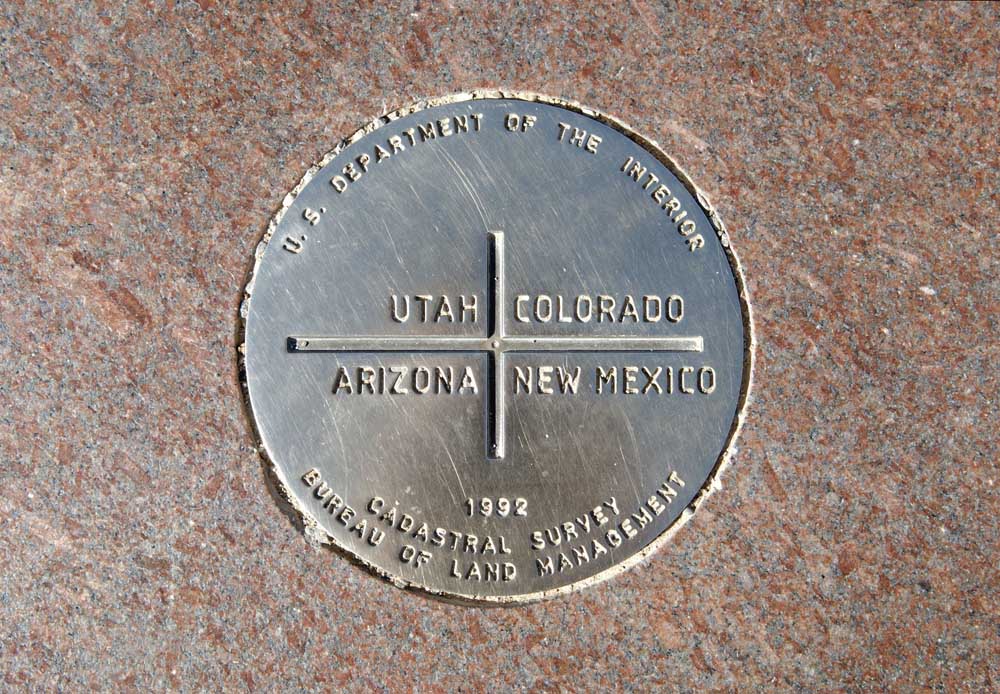
- The Four Corners National Monument marks where the state lines of Utah, Colorado, Arizona and New Mexico intersect.(123RF)
COLORADO SPRINGS, Colo. — One of Colorado’s popular southwest attractions, the Four Corners National Monument is placed where the Arizona, Colorado, New Mexico and Utah corners meet so perfectly that it’s possible for one to have limbs in each state at a single time. However, there’s been quite a bit of debate recently about the accuracy of its placement. Either it’s right, and the 250,000 or so people that visit this attraction each year are doing something pretty awesome … or the placement is wrong, and 250,000 people are taking a picture on top of a completely random spot in the middle of the desert. We wanted to get to the bottom of it, and we found that what many believe isn’t quite right.
First, let’s consider the history behind the lines that make up the Four Corners. Once Native American land, the area was claimed by Spain in the 16th century. Following Mexico’s independence from Spain in 1821, the land became governed by Mexico. However, this was quickly given to the United States, part of the treaty that followed a U.S. victory in the Mexican-American War.
While this area then encompassed the entire “Four Corners” region, the Compromise of 1850 drew a line along the 37th parallel north, which made the first split between the New Mexico Territory to the south and the Utah Territory to the north. In 1861, the Utah Territory was split by the U.S. Government, forming the Utah Territory to the west and the Colorado Territory to the east, along the 32nd meridian west of Washington. The bottom half of the territory (New Mexico Territory) was then split just prior to the Civil War, when disgruntled southerners of the territory created the Arizona Territory stretching below the upper half of the New Mexico Territory. This dividing line was then shifted by the victorious Union in 1875 to be vertical instead of horizontal, creating a Four Corners intersection that resembles what is seen today.
While the first official Four Corners marker was placed in 1875, it was destroyed within a couple decades. This meant a new marker was installed in 1912 — a simple concrete pad around a marker. Around this time travelers started to come to take pictures at the site. This led the local Navajo Nation Parks and Recreation Department to make the destination more official, despite debate over the marker’s placement, and the spot has been a tourist attraction ever since, with an official opening date in 1931.
So why the confusion over the placement of the “Four Corners” marker? It’s since been found that the borders of the states leading to the monument don’t exactly follow the lines of the parallel and meridian as closely as they were designed to, and as a result, the intersection of the lines was misplaced in initial surveys of the late 1800s. In 2009, this was discovered with modern GPS and the debate went viral, with claims that the marker was 2.5 miles west of where it should be. That’s NOT true. What many of these internet sleuths forgot was that the initial surveys were completed using the Washington meridian, not the modern Prime Meridian, which was adopted in 1912. That is the source of this discrepancy, as there’s slight variance between the two lines. However, that’s not where the debate stops.
While the placement of the Four Corners National Monument isn’t 2.5 miles off of it’s spot, it is 1,807 feet east of where it should be, according to a U.S. National Geodetic Survey spokesperson. This wasn’t due to a misunderstanding of the meridian line, though. It was due to the primitive tools that were available at the time of the official land assessment. That being said, because those official survey markers were legally binding when agreed upon by all parties, they’re official — even if an error is discovered at a later date.
So, is the Four Corners Monument in the correct spot? Technically, yes, because the original markers were binding after all parties accepted them. Would the Four Corners Monument likely be in a different spot today if modern technology had been available during initial surveys of the land? Yes — but it would have been 1,807 feet to the east, not 2.5 miles to the west like the popular internet rumor states. This begs the final question: are the 250,000 people that visit this attraction each year heading to a random spot in the desert or something more official? In this instance, the legal system overrides the inaccuracies of original surveys thanks to the fact that the “inaccurate lines” were made official by a congressional decision and that a 1925 U.S. Supreme Court ruling confirmed the spot of the Monument as the official intersection point of all four states.
Here’s a quote from the National Geodetic Society that summarizes this conclusion: “the location of the physical monument is the ultimate authority in delineating a boundary. Issues of legality trump scientific details, and the intended location of the point becomes secondary information.”


Best of the Best of Bend 2025

-
-
-